
Cycle Route Tour de Manche
Actions
![]()
Please wait - map data are loading
Added on 27 Jun 2014,
last edited by biroto-Redaktion on 04 Apr 2024
Actions
Cycle route metrics
Total distance in km
999
Information about rights to the gps-track data | |
|---|---|
Rights owner | OpenStreetMap and Contributors + biroto-Redaktion (biroto.eu) |
Rights characteristic / license | Contains information from OpenStreetMap, which is made available here under the Open Database License(ODbL) |
Link to the description of the license | |
GPX file taken from | |
GPX file uploaded | by biroto-Redaktion on 04 Apr 2024
|
Track points in total
18.786
Track points per km (avg)
14
Start/endpoint
Start location
Cherbourg-en-Cotentin, Normandie, FR (4 m NHN)
End location
Cherbourg-en-Cotentin, Normandie, FR (4 m NHN)
Signposting
Signage in France |
|
In the UK, the route follows Routes 2, 34, 28 and 27 as it passes through Dorset and Devon between Poole and Plymouth. |
|

Sources of information
Remarks
Between Binic and Paimpol there is a gap in the track for about 30 km.
Beds4Cyclists, worth visiting and infrastructure
Name and address
Latitude / Longitude
Phone
Fax
Mobile
Type of accommodation
Rating for cyclists
Route km
Dist. to route
Elevation
3 km
0,1 km
21 m
Information about copyright | |
|---|---|
Rights owner | |
Rights characteristic / license | by-sa: CREATIVE COMMONS Attribution-ShareAlike |
Link to the description of the license | |
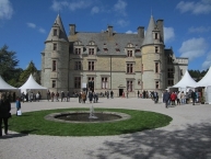
Image taken over from | commons.wikimedia.org/wiki/File:Château_des_Ravalet_-_Cour_d'honneur.JPG |
Image has been uploaded | by biroto-Redaktion on 25 Apr 2015
|
Information about copyright | |
|---|---|
Rights owner | |
Rights characteristic / license | by-sa: CREATIVE COMMONS Attribution-ShareAlike |
Link to the description of the license | |
Image taken over from | |
Image has been uploaded | by biroto-Redaktion on 25 Apr 2015
|
Information about copyright | |
|---|---|
Rights owner | |
Rights characteristic / license | by-sa: CREATIVE COMMONS Attribution-ShareAlike |
Link to the description of the license | |
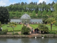
Image taken over from | commons.wikimedia.org/wiki/File:Château_des_Ravalet_-_Bassin_et_serre_(2).JPG |
Image has been uploaded | by biroto-Redaktion on 25 Apr 2015
|
Information about copyright | |
|---|---|
Rights owner | |
Rights characteristic / license | by-sa: CREATIVE COMMONS Attribution-ShareAlike |
Link to the description of the license | |
Image taken over from | commons.wikimedia.org/wiki/File:Château_des_Ravalet_-_Tour_de_l'horloge_(2).JPG |
Image has been uploaded | by biroto-Redaktion on 25 Apr 2015
|
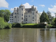
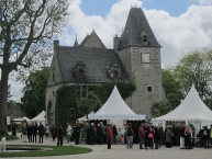
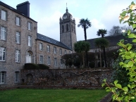
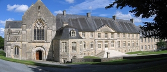
Das Schloss Ravalet ist ein ab 1562 entstandenes Renaissance-Schloss im Département Manche in der Normandie. Es ist im Besitz der Gemeinde Cherbourg-Octeville, befindet sich aber auf dem Gebiet der Gemeinde Tourlaville ![]() . Vor dem Schloss liegt ein im 19. Jahrhundert entstandener Park.
. Vor dem Schloss liegt ein im 19. Jahrhundert entstandener Park.
Die damalige Burg gehörte zur königlichen Domäne und wurde von König Franz I. an Jean II. de Raval aus Tourlaville verkauft. Dieser ließ 1562 ein Renaissance-Schloss errichten, lediglich der Bergfried blieb in Teilen bestehen. Nach finanziellen Problemen verkauften die Herren von Raval 1653 das Schloss an Charles de Franquetot, der insbesondere das Innere renovieren ließ. Nach dessen Ermordung hatte die Anlage mehrere Besitzer, darunter die Boudets aus Crosville und die Fouquets aus Reville. 1661 wurde es als Bauernhof genutzt.
Clérel Hervé de Tocqueville nahm es 1777 in Besitz. Dessen Enkel René de Tocqueville, Oberbürgermeister der Stadt, veranlasste die Renovierung der Gebäude und Gärten und baute ein großes Gewächshaus. Im Jahr 1906 musste er es jedoch verkaufen. Im Ersten Weltkrieg dienten die Gebäude als Lazarett. Schon 1930 war das Schloss als Monument historique im Katalog aufgeführt. Die Stadt Cherbourg erwarb das Anwesen im Jahr 1935. Während des Zweiten Weltkrieges war es von der deutschen Armee und nach der Befreiung von amerikanischer Truppen besetzt.
Während der Park das ganze Jahr über öffentlich zugänglich ist, ist das Schloss nur während der Tag des offenen Denkmals (Journées du patrimoine) zu besichtigen. Park und Gewächshaus stehen gemeinsam mit dem Schlossbau seit März 1996 unter Denkmalschutz.
Der Renaissance-Park mit Wassergräben wurde 1870 mit zwei Teichen und einer Höhle versehen. Im Park und im zwischen 1872 und 1875 umgestalteten Gewächshaus befinden sich viele exotische Pflanzen und Bäume. Der Park wurde seitens der Stadt Cherbourg 1935 zum öffentlichen Garten erklärt. Ein Sturm von 1987 verursachte große Schäden.
Information about copyright | |
|---|---|
Rights characteristic / license | by-sa: CREATIVE COMMONS Attribution-ShareAlike |
Link to the description of the license | |
Input taken over from: |
Seite „Schloss Ravalet“. In: Wikipedia, Die freie Enzyklopädie. Bearbeitungsstand: 21. Februar 2015, 18:15 UTC. URL: http://de.wikipedia.org/w/index.php?title=Schloss_Ravalet&oldid=139075656 (Abgerufen: 25. April 2015, 16:47 UTC) |
taken over / edited on | 25 Apr 2015
|
taken over / edited by |
|
27 km
0,4 km
47 m
Information about copyright | |
|---|---|
Rights owner | |
Rights characteristic / license | by-sa: CREATIVE COMMONS Attribution-ShareAlike |
Link to the description of the license | |
Image taken over from | commons.wikimedia.org/wiki/File:Abbaye_Notre-Dame-de-Grâce_de_Bricquebec_-_Église_abbatiale_01.JPG |
Image has been uploaded | by biroto-Redaktion on 26 Apr 2015
|
Information about copyright | |
|---|---|
Rights owner | |
Rights characteristic / license | cc0: Public Domain no Rights reserved |
Link to the description of the license | |
Image taken over from | commons.wikimedia.org/wiki/File:Abbaye_Notre-Dame_de_Grâce_de_Bricquebec.JPG |
Image has been uploaded | by biroto-Redaktion on 26 Apr 2015
|
Information about copyright | |
|---|---|
Rights owner | |
Rights characteristic / license | cc0: Public Domain no Rights reserved |
Link to the description of the license | |
Image taken over from | |
Image has been uploaded | by biroto-Redaktion on 26 Apr 2015
|
Information about copyright | |
|---|---|
Rights owner | |
Rights characteristic / license | by-sa: CREATIVE COMMONS Attribution-ShareAlike |
Link to the description of the license | |
Image taken over from | commons.wikimedia.org/wiki/File:Château_de_Bricquebec_08.JPG |
Image has been uploaded | by biroto-Redaktion on 26 Apr 2015
|
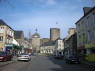
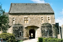
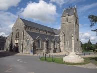
Bricquebec ist eine französische Stadt mit 4238 Einwohnern (Stand 1. Januar 2012) im Département Manche in der Region Basse-Normandie. Die Einwohner nennen sich Bricquebétais.
Sehenswürdigkeiten
- Schloss (9. Jahrhundert)
- Abtei Notre-Dame-de-Grâce de Bricquebec (19. Jahrhundert)
Information about copyright | |
|---|---|
Rights characteristic / license | by-sa: CREATIVE COMMONS Attribution-ShareAlike |
Link to the description of the license | |
Input taken over from: |
Seite „Bricquebec“. In: Wikipedia, Die freie Enzyklopädie. Bearbeitungsstand: 1. November 2014, 05:07 UTC. URL: http://de.wikipedia.org/w/index.php?title=Bricquebec&oldid=135411101 (Abgerufen: 26. April 2015, 13:11 UTC) |
taken over / edited on | 26 Apr 2015
|
taken over / edited by |
|
40 km
0,6 km
8 m
Information about copyright | |
|---|---|
Rights owner | |
Rights characteristic / license | by-sa: CREATIVE COMMONS Attribution-ShareAlike |
Link to the description of the license | |
Image taken over from | commons.wikimedia.org/wiki/File:Abbaye_st_sauveur_panorama_1.jpg |
Image has been uploaded | by biroto-Redaktion on 26 Apr 2015
|
Information about copyright | |
|---|---|
Rights owner | |
Rights characteristic / license | by-sa: CREATIVE COMMONS Attribution-ShareAlike |
Link to the description of the license | |
Image taken over from | commons.wikimedia.org/wiki/File:Château_de_Saint-Sauveur-le-Vicomte_02.JPG |
Image has been uploaded | by biroto-Redaktion on 26 Apr 2015
|
Information about copyright | |
|---|---|
Rights owner | |
Rights characteristic / license | by-sa: CREATIVE COMMONS Attribution-ShareAlike |
Link to the description of the license | |
Image taken over from | commons.wikimedia.org/wiki/File:Saint-Sauveur-le_Vicomte_(Château)_3.jpg |
Image has been uploaded | by biroto-Redaktion on 26 Apr 2015
|
Information about copyright | |
|---|---|
Rights owner | |
Rights characteristic / license | by-sa: CREATIVE COMMONS Attribution-ShareAlike |
Link to the description of the license | |
Image taken over from | commons.wikimedia.org/wiki/File:Église_Saint-Jean-Baptiste_de_Saint-Sauveur-le-Vicomte.JPG |
Image has been uploaded | by biroto-Redaktion on 26 Apr 2015
|
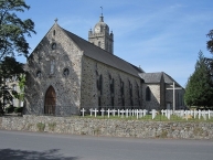
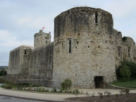
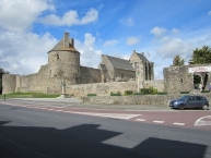
Saint-Sauveur-le-Vicomte ist eine französische Gemeinde mit 2157 Einwohnern (Stand 1. Januar 2012) im Département Manche in der Region Basse-Normandie.
Nach der Landung der Alliierten in der Normandie am D-Day, dem 6. Juni 1944, war die Stadt lange umkämpft. Zum Beispiel nahm Matthew B. Ridgway, später ein hoher US-General, mit der 82. Luftlandedivision am D-Day teil und kämpfte dann 33 Tage mit seinen Truppen in und um Saint-Sauveur-le-Vicomte.
Sehenswürdigkeiten
- Burg (11. Jahrhundert, Monument historique)
- Abtei (12. Jahrhundert, Abteikirche Monument historique)
- Museum Barbey d’Aurevilly im Geburtshaus des Schriftstellers Jules Amédée Barbey d’Aurevilly (Monument historique)
- Pfarrkirche (teilweise 12. Jahrhundert)
- Kirche von Saint-Claude de Selsouëf mit einer Marienskulptur aus dem 15. Jahrhundert (Monument historique)
- Schloss Les Fresnais
- Schloss Beaulieu
Information about copyright | |
|---|---|
Rights characteristic / license | by-sa: CREATIVE COMMONS Attribution-ShareAlike |
Link to the description of the license | |
Input taken over from: |
Seite „Saint-Sauveur-le-Vicomte“. In: Wikipedia, Die freie Enzyklopädie. Bearbeitungsstand: 22. Oktober 2014, 22:30 UTC. URL: http://de.wikipedia.org/w/index.php?title=Saint-Sauveur-le-Vicomte&oldid=135130668 (Abgerufen: 26. April 2015, 12:58 UTC) |
taken over / edited on | 26 Apr 2015
|
taken over / edited by |
|
76 km
2,7 km
13 m
Information about copyright | |
|---|---|
Rights owner | |
Rights characteristic / license | by-sa: CREATIVE COMMONS Attribution-ShareAlike |
Link to the description of the license | |
Image taken over from | |
Image has been uploaded | by biroto-Redaktion on 26 Apr 2015
|
Information about copyright | |
|---|---|
Rights owner | |
Rights characteristic / license | by-sa: CREATIVE COMMONS Attribution-ShareAlike |
Link to the description of the license | |
Image taken over from | |
Image has been uploaded | by biroto-Redaktion on 26 Apr 2015
|
Information about copyright | |
|---|---|
Rights owner | |
Rights characteristic / license | by-sa: CREATIVE COMMONS Attribution-ShareAlike |
Link to the description of the license | |
Image taken over from | |
Image has been uploaded | by biroto-Redaktion on 26 Apr 2015
|
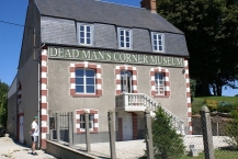
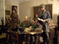
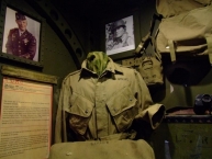
The D-Day Paratroopers Historical Center’s mission is to pass on the memory and to collect authentic pieces to preserve them and make them accessible to the public through exhibitions and publications.
Information about copyright | |
|---|---|
Rights characteristic / license | by-sa: CREATIVE COMMONS Attribution-ShareAlike |
Link to the description of the license | |
taken over / edited on | 26 Apr 2015
|
taken over / edited by |
|
Hours of opening
Every day, from 9:00 am to 06:00 pm.
Closed on Sundays between: 01/10 and 30/04.
Closed on: December 24 and 25 - December 31 and January 1.
77 km
0,1 km
14 m
![]()