
Cycle Tour München-Verona
Travel report: Over Alperne på to hjul fra Sydtyskland via Tyrol/Østrig til Norditalien
Actions
![]()
Please wait - map data are loading
Added on 26 Aug 2021,
last edited by Ottocolor on 03 Aug 2022
Actions
Cycle route metrics
planned
ridden
Total distance in km
501
519
Cumulative elevation gain in m
12.767
3.335
Avg. slope uphill in %
2,55
0,64
Cumulative elevation loss in m
13.252
3.817
Total cycling hours
-
55,5
Avg. pace in km/h
-
9,4
Information about rights to the gps-track data | |
|---|---|
Rights owner | |
Rights characteristic / license | cc0: Public Domain no Rights reserved |
Link to the description of the license | |
GPX file uploaded | by Ottocolor on 29 Apr 2022
|
Track points in total
8.608
8.738
Track points per km (avg)
17
17
Start/endpoint
Start location
Aying, Bayern, DE (605 m NHN)
End location
Verona, Veneto, IT (121 m NHN)
Character
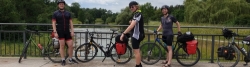
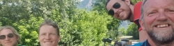
Two weeks of cycling holiday with tent and camping gear. Planned to be ridden in July 2022. Participants: Four people. Alexander Slot Jessen, Simon Slot Jessen, Thomas Holst Larsen and myself.
Our goal is to cross the Alps via the Brenner pass. Consequently, we start north of the Alps, in Munich and end south of the mountain range in Verona.
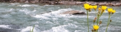
The cycle route follows rivers on almost all its course, however several ones and as well up- and downstream. From north to south they are: Mangfall (down), Inn (up), Sill (up, steeply!), Eisack/Isarco (down) and Adige/Etsch (down) (the latter two written in both German and Italian).
Besides the rivers, the cycle route also on a very large part of its course follows bike paths, mostly in its own course, separately running through nature. The remainder is on bike lanes in towns and cities, and minor roads in towns and cities and in the countryside. On one occasion, the last 7.5 km and 260 metres of altitude up to the Brenner pass will be ridden on a road without a bike lane with medium traffic, so there we'll be somewhat exposed. The reward comes on the Italian side of the pass in form of the very long and superb bike path ("pista ciclabile" in Italian), which goes on all the way to the suburbs of Verona. The detour to the Garda lake, from Mori to Torbole and back, takes place also on bike paths or minor roads without much traffic.
For the last 30 km or so the cycle route doesn't follow the Adige, but a canal, the so-called Canale Biffis, named after its constructor, which was built a hundred years ago out of irrigation and powerproducing purposes. It runs partly in tunnels through the rocks, where no cycling route, of course, is placed and comprises also a high bridge above a gorge.
Our goal city Verona is a huge reward in itself as well, as our starting point of Munich also has its certain virtues. Consequently, they are both offered a rest day, in fact it's one and a half in Verona, as we intend to take a rain in the late afternoon back to Munich. Apart from these, we plan rest days in Innsbruck and Torbole.
Accommodation takes normally place on campsites in our tents, which we carry with us. Innsbruck and Trento, however, lack well situated camp sites, so here we'll sleep in hostels. In Munich (outbound) and Verona we also go camping. Here Thomas' mother Susanne joins us, and the two of them will stay in Verona for some days more. So Thomas doesn't go back home along with us. The three remaining participants will sleep in a hostel in Munich near the central railway station before the train trip back home to Denmark.
STATISTICS
Countries:
- Germany: 54 km
- Austria: 145 km
- Italy: 302 km
Rivers:
- Mangfall: (route km 5-21) 16 km
- Inn: (km 44-158) 114 km
- Sill: (km 159-197) 38 km
- Eisack/Isarco: (km 198-307) 109 km
- Etsch/Adige: (km 307-399 and 428-499) 163 km
Total route along rivers 440 km. (without rivers 41 km)
Information about copyright | |
|---|---|
Rights characteristic / license | by-sa: CREATIVE COMMONS Attribution-ShareAlike |
Link to the description of the license | |
taken over / edited on | 26 Aug 2021 - 28 Apr 2022
|
taken over / edited by |
|
Landscape
Magnificent Alpine landscape with high, snowtopped mountains! Such is the background for our cycling holiday for most of its course. Apart from the Brenner pass this, however, doesn't involve serious, long climbs, which have to be negotiated.
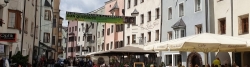
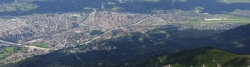
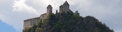
Thanks to the rivers! Munich is situated on the Danube tributary Isar, which the camp site in the southern suburb of Thalkirchen lies right down to. But the watershed to the Inn tributary of Mangfall demands no climbs. The Inn is another Danube tributary, which we start to follow just north of the German/Austrian border at Kufstein, where we also enter the Alps proper. As mentioned, without altitude metres thanks to the river. On this strech the valley is fairly broad and, alas, densely built up and populated. Moreover the cycle route runs close to the Inn valley motorway, which will somewhat decrease the Alpine idyll. This motorway is also going to be our "dear" companion up to the Brenner pass and, in fact, all the way down to shortly before Verona. On the second day of the holiday we enter the Tyrolean capital of Innsbruck. After a restday in this beautiful spot we'll venture up the Brenner pass in two serious climbs, each comprising of about 400 altitude metres. The first one, from Innsbruck to the village of Patsch is clearly the most challenging, as the 430 altitude metres have to be managed within just 7 km, so, I guess, we'll wheel our bikes for some distance with their heavy load. Shortly after Patsch there's a view to the "Europe Bridge", a high motorway bridge from the 1960's, when motored tourism to Italy begun. The second climb demands also about 400 altitude metres, but within some 15 km's. All the way from Innsbruck we follow the river Sill, which has its source near the Brenner pass. Here lies a beautiful mountain lake, the Brenner lake, and on a hot day it's definetely a good idea with a swim in the always cold water.
Nearby runs not only the motorway, but also a normal road and a railway line, which make it the by far most frequented Alpine crossing point for cars. About three million lorries cross the pass every year. Knowing that they are not allowed to go on weekends, it's insane how many there are on weekdays.
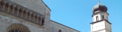
The main Alpine mountain ridge is, of course, a European watershed, and the river, we follow now runs to the South heading for the Adriatic Sea, a part of the Mediterranean. It's called Isarco in Italian and Eisack in German. Although, Italy starts up here, people speak mostly German, as it's the province of South Tyrol, until the end of WWI belonging to Austria. In Italian the province is called Alto Adige, not to mentionanything about the former ownership, but just Upper Adige. Adige is the river, which the Eisack/Isarco flows into just south of the provincial capital of Bolzano/Bozen, and which we will go along all the way down to Verona.
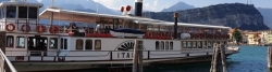
But that's not true, because about 70 km before Verona we leave the river valley in favour of the Garda lake in order to have a restday on its shores in Torbole on the lake's northern tip. The lake's surface is just 66 m above sea level, but the surroundings are still highly Alpine. This adds to its character and its popularity with tourists. The southern half of the lake lies on the Po plain, as the Alps end very abrubtly to the south. Consequently, the lake has room to broaden, while the northern half is narrow. The trip back from the lake involves a climp onto a plateau. If it hadn't been there, the Adige would have flown into Lake Garda, which it patently doesn't, so we have to go back to the Adige valley. On the last part of its course before Verona it runs past some mighty and impressive rocks, which we partly have to pass, so it's going to be a quite hard last stage, before we, quite sweaty, I suppose, arrive in Romeo's and Julia's city.
We have now left the Alps, but their southern slopes end just a few kilometres north of Verona. Verona is an ancient city, which is highly visible everywhere in it with a magnitude of historical buildings from the Roman period to the young Italian republic. The most famous building must be the Roman arena, where once gladiator fights were held, but nowadays they stage operas during summer. Here our trip ends, but the river Adige flows on as a slow and broad river until its mouth into the Adriatic Sea, just north of the Po's, Italy's biggest river.
The campsite of Verona is situated right next to the big palace, overlooking the city with a panoramic view, so it's indeed a tremendous place to end our cycling holiday, before the way goes back the same route, we've cycled, by train. By this means of transportation it can be done in about five and a half hours, and the next day we intend to go back to Denmark by train.
Apart from the magnificent start and finish cities of Munich and Verona, we get the chance to visit several interesting towns and cities along the way. Two of them are even offered a rest day, namely Innsbruck and Torbole on Lake Garda. In the former we could take the train and cable car ("Nordkettenbahn" up to Hafelekarspitze (2334 m a.s.l. and 1,760 m above the city). In the latter we could take a boat trip on Lake Garda to Riva del Garda, which is more worth seeing than Torbole. Once we spend the night in the center of a beautiful old town, namely Trento. Three times we sleep on a campsite near interesting cities, namely Kufstein (5 km from the center), Sterzing / Vipiteno (3 km) and Bolzano / Bozen (4 km). In all cases, the center comes before the campsite, so we'll have the choice between having a look at the town first or go in there by bike after the tent pitching. In addition, we also pass towns and cities with historic centers on the route. Here the weather, the clock and our interest can decide, whether we'll have a look at it. I could mention Rosenheim (Germany) and Rattenberg (Austria), Franzensfeste / Fortezza (like the rest in Italy), Brixen / Bressanone, Klausen / Chiusa, Neumarkt / Egna, Salorno / Salurn and Rivoli Veronese.
Information about copyright | |
|---|---|
Rights characteristic / license | by-sa: CREATIVE COMMONS Attribution-ShareAlike |
Link to the description of the license | |
taken over / edited on | 26 Aug 2021 - 07 Dec 2021
|
taken over / edited by |
|
Travel to and from ...
OUTBOUND:
Train transport Odense-Munich for the three of us. Alexander goes by Flixbus.
Commuter train transport (S7) from Siemenswerke station near Thalkirchen campsite via Munich central station (without interchange) to the station of Grosshelfendorf, southeast of Munich. E.g. departure from Siemenswerke at 10.33 am, arrival at Grosshelfendorf at 11.35 am.
HOMEBOUND:
Train transport from Verona to Munich. Departure from Verona Porta Nuova at 3.01 pm, arrival at Munich central station at 8.26 pm via EC82 directly. Duration 5 hours 25 mins.
After a night's sleep here we go home by train.
Sources of information
Accommodation:
- http://campingplatz-thalkirchen.de/
- http://camping.hager.tirol/
- https://www.pensionstoi.at/innsbruck/
- https://www.camping.info/en/campsite/camping-gilfenklamm
- https://www.moosbauer.com/
- http://www.bnbtrento.it/
- http://www.campingeuropatorbole.it/
- https://www.campingcastelsanpietro.com/
- https://www.euro-youth-hotel.de/
Stages
Information about copyright | |
|---|---|
Rights owner | |
Rights characteristic / license | by-sa: CREATIVE COMMONS Attribution-ShareAlike |
Link to the description of the license | |
Image has been uploaded | by Ottocolor on 08 Aug 2022
|
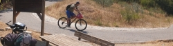
81 km
Großhelfendorf-Kufstein
Information about copyright | |
|---|---|
Rights owner | |
Rights characteristic / license | by-sa: CREATIVE COMMONS Attribution-ShareAlike |
Link to the description of the license | |
Image has been uploaded | by Ottocolor on 08 Aug 2022
|
85 km
Kufstein-Innsbruck
Information about copyright | |
|---|---|
Rights owner | |
Rights characteristic / license | by-sa: CREATIVE COMMONS Attribution-ShareAlike |
Link to the description of the license | |
Image has been uploaded | by Ottocolor on 08 Aug 2022
|
Hviledag/restday Innsbruck
Information about copyright | |
|---|---|
Rights owner | |
Rights characteristic / license | by-sa: CREATIVE COMMONS Attribution-ShareAlike |
Link to the description of the license | |
Image has been uploaded | by Ottocolor on 08 Aug 2022
|
90 km
Innsbruck-Vahrn
Information about copyright | |
|---|---|
Rights owner | |
Rights characteristic / license | by-sa: CREATIVE COMMONS Attribution-ShareAlike |
Link to the description of the license | |
Image has been uploaded | by Ottocolor on 08 Aug 2022
|
61 km
Vahrn-Bolzano
Information about copyright | |
|---|---|
Rights owner | |
Rights characteristic / license | by-sa: CREATIVE COMMONS Attribution-ShareAlike |
Link to the description of the license | |
Image has been uploaded | by Ottocolor on 08 Aug 2022
|
70 km
Bolzano-Trento
Information about copyright | |
|---|---|
Rights owner | |
Rights characteristic / license | by-sa: CREATIVE COMMONS Attribution-ShareAlike |
Link to the description of the license | |
Image has been uploaded | by Ottocolor on 08 Aug 2022
|
46 km
Trento-Torbole
Information about copyright | |
|---|---|
Rights owner | |
Rights characteristic / license | by-sa: CREATIVE COMMONS Attribution-ShareAlike |
Link to the description of the license | |
Image has been uploaded | by Ottocolor on 08 Aug 2022
|
Hviledag/restday Torbole
Information about copyright | |
|---|---|
Rights owner | |
Rights characteristic / license | by-sa: CREATIVE COMMONS Attribution-ShareAlike |
Link to the description of the license | |
Image has been uploaded | by Ottocolor on 08 Aug 2022
|
86 km
Torbole-Verona
Beds4Cyclists, worth visiting and infrastructure
Name and address
Latitude / Longitude
Phone
Fax
Mobile
Type of accommodation
Rating for cyclists
Route km
Dist. to route
Elevation
0 km
2,8 km
601 m
Information about copyright | |
|---|---|
Rights owner | |
Rights characteristic / license | by-sa: CREATIVE COMMONS Attribution-ShareAlike |
Link to the description of the license | |
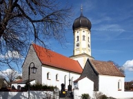
Image taken over from | commons.wikimedia.org/wiki/File:Aying_St._Andreas_southwest.jpg |
Image has been uploaded | by biroto-Redaktion on 23 Dec 2012
|
Aying ist eine Gemeinde im Südosten des Landkreises München im Regierungsbezirk Oberbayern, etwa 25 km südöstlich von München ![]() (Innenstadt) entfernt.
(Innenstadt) entfernt.
Die Ortschaften der Gemeinde haben sich ihren dörflichen Charakter weitgehend erhalten können. Die Brauerei Aying ![]() , die Biergärten und das Ayinger Zentrum mit einem Brauereigasthof und dem höchsten Maibaum Europas sind Anziehungspunkte für Touristen aus aller Welt. Die Bräudult vor den Pfingstferien, das Johannifeuer der Freiwilligen Feuerwehr Aying im Juni und der Bräukirta (Kirchweih) im Oktober mit großem Bierzelt sind alljährliche Festivitäten in Aying. Durch den Hofoldinger Forst bis zur "Römersiedlung" bei Peiß und weiter nach Kleinhelfendorf zur Emmeramskapelle führt die Römerstraße "Via Julia
, die Biergärten und das Ayinger Zentrum mit einem Brauereigasthof und dem höchsten Maibaum Europas sind Anziehungspunkte für Touristen aus aller Welt. Die Bräudult vor den Pfingstferien, das Johannifeuer der Freiwilligen Feuerwehr Aying im Juni und der Bräukirta (Kirchweih) im Oktober mit großem Bierzelt sind alljährliche Festivitäten in Aying. Durch den Hofoldinger Forst bis zur "Römersiedlung" bei Peiß und weiter nach Kleinhelfendorf zur Emmeramskapelle führt die Römerstraße "Via Julia ![]() ", als Radwanderweg mit blauen Schildern und Schautafeln versehen.
", als Radwanderweg mit blauen Schildern und Schautafeln versehen.
Bauwerke
- Pfarr- und Wallfahrtskirche Sankt Emmeram Kleinhelfendorf
- Marterkapelle in Kleinhelfendorf
- Brunnenkapelle in Kleinhelfendorf
- Pfarrkirche Sankt Andreas in Aying
- Kriegerkapelle Sankt Lambert in Aying (auf dem Kirchenfriedhof)
- Kapelle zum Gegeißelten Heiland in Dürrnhaar
- Filialkirche Sankt Nikolaus in Peiß
- Grotte (kleine Kapelle in Kleinkarolinenfeld
 , Waldlichtung)
Information about copyright | |
|---|---|
Rights characteristic / license | by-sa: CREATIVE COMMONS Attribution-ShareAlike |
Link to the description of the license | |
Input taken over from: |
Seite „Aying“. In: Wikipedia, Die freie Enzyklopädie. Bearbeitungsstand: 22. Dezember 2012, 04:42 UTC. URL: http://de.wikipedia.org/w/index.php?title=Aying&oldid=111955471 (Abgerufen: 23. Dezember 2012, 19:03 UTC) |
taken over / edited on | 23 Dec 2012
|
taken over / edited by |
|
15 km
1,1 km
505 m
23 km
0,8 km
476 m
24 km
0,3 km
495 m
33 km
1,1 km
443 m
![]()