
Cycle Tour Bike trip to the North Cape
Dag 23, etape/stage 17: Molkoköngäs-Kittilä
![]()
Please wait - map data are loading
Added on 03 Mar 2014
last edited by Ottocolor on 20 Apr 2014
Cycle route metrics
ridden
Total distance in km
76
Cumulative elevation gain in m
350
Avg. slope uphill in %
0,46
Cumulative elevation loss in m
299
Min. height
120
Max. height
211
Information about rights to the gps-track data | |
|---|---|
Rights owner | |
Rights characteristic / license | by-sa: CREATIVE COMMONS Attribution-ShareAlike |
Link to the description of the license | |
GPX file uploaded | by Ottocolor on 06 Mar 2014
|
Track points in total
555
Track points per km (avg)
7
Start/endpoint
Start location
Rovaniemi, Northern Finland, FI (121 m NHN)
End location
Kittilä, Northern Finland, FI (172 m NHN)
ridden on
08 Jun 2010
Weather
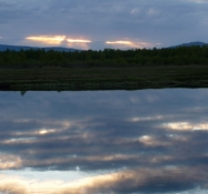
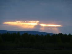
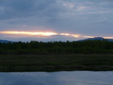
Good weather! Quite sunny, almost no wind and not especially cold, about 8-9 degrees Centigrade.
Accommodation
Kittilän Lomamökit Oy
Sodankyläntie 65
FI-99100 Kittilä
Properties
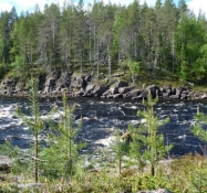
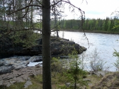
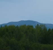
I followed the main road to Kittilä all day long with two detours on gravel roads away from the road and back again. Very little traffic on the main road, which is rather narrow, so when an occasional lorry passes from behind, it's unpleasant.
Remarks
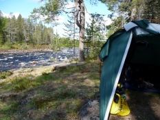
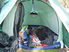
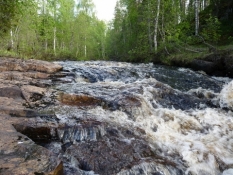
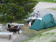
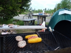
Today my goal was the town of Kittilä, which I was to reach in two days from Rovaniemi. The morning I spent on my lovely camping spot in the woods at the cataract. After my departure I quite soon have lunch at a church. Unfortunately, there is no water tap. Coffee break at a little water fall at a small tributary near the place it went into Ounasjoki. I got water from the river. Afterwards I cycled for a long time without seeing a single soul. Then i chatted with some boys, who were angling from a bridge in the village of Kaukonen. I easily found the camping site in Kittilä, where I had a barbecue meal after a shopping trip into town. Afterwards I washed my clothes and enjoyed a trip to the sauna.
Travel report
Information about copyright | |
|---|---|
Rights owner | |
Rights characteristic / license | by-sa: CREATIVE COMMONS Attribution-ShareAlike |
Link to the description of the license | |
Image has been uploaded | by Ottocolor on 20 Apr 2014
|
Information about copyright | |
|---|---|
Rights owner | |
Rights characteristic / license | by-sa: CREATIVE COMMONS Attribution-ShareAlike |
Link to the description of the license | |
Image has been uploaded | by Ottocolor on 20 Apr 2014
|
Information about copyright | |
|---|---|
Rights owner | |
Rights characteristic / license | by-sa: CREATIVE COMMONS Attribution-ShareAlike |
Link to the description of the license | |
Image has been uploaded | by Ottocolor on 20 Apr 2014
|
Information about copyright | |
|---|---|
Rights owner | |
Rights characteristic / license | by-sa: CREATIVE COMMONS Attribution-ShareAlike |
Link to the description of the license | |
Image has been uploaded | by Ottocolor on 20 Apr 2014
|
Information about copyright | |
|---|---|
Rights owner | |
Rights characteristic / license | by-sa: CREATIVE COMMONS Attribution-ShareAlike |
Link to the description of the license | |
Image has been uploaded | by Ottocolor on 20 Apr 2014
|
Information about copyright | |
|---|---|
Rights owner | |
Rights characteristic / license | by-sa: CREATIVE COMMONS Attribution-ShareAlike |
Link to the description of the license | |
Image has been uploaded | by Ottocolor on 20 Apr 2014
|
Information about copyright | |
|---|---|
Rights owner | |
Rights characteristic / license | by-sa: CREATIVE COMMONS Attribution-ShareAlike |
Link to the description of the license | |
Image has been uploaded | by Ottocolor on 20 Apr 2014
|
Information about copyright | |
|---|---|
Rights owner | |
Rights characteristic / license | by-sa: CREATIVE COMMONS Attribution-ShareAlike |
Link to the description of the license | |
Image has been uploaded | by Ottocolor on 20 Apr 2014
|
Information about copyright | |
|---|---|
Rights owner | |
Rights characteristic / license | by-sa: CREATIVE COMMONS Attribution-ShareAlike |
Link to the description of the license | |
Image has been uploaded | by Ottocolor on 20 Apr 2014
|
Information about copyright | |
|---|---|
Rights owner | |
Rights characteristic / license | by-sa: CREATIVE COMMONS Attribution-ShareAlike |
Link to the description of the license | |
Image has been uploaded | by Ottocolor on 20 Apr 2014
|
Information about copyright | |
|---|---|
Rights owner | |
Rights characteristic / license | by-sa: CREATIVE COMMONS Attribution-ShareAlike |
Link to the description of the license | |
Image has been uploaded | by Ottocolor on 20 Apr 2014
|