
Cycle Tour ChaumontStainDizierTroyes
Planned tour
Actions
![]()
Please wait - map data are loading
Added on 06 May 2019,
last edited by suphi on 06 May 2019
Actions
Cycle route metrics
planned
ridden
Total distance in km
194
0
Cumulative elevation gain in m
1.450
0
Avg. slope uphill in %
0,75
-
Cumulative elevation loss in m
1.594
0
Information about rights to the gps-track data | |
|---|---|
Rights owner | |
Rights characteristic / license | by: CREATIVE COMMONS Attribution |
Link to the description of the license | |
GPX file uploaded | by suphi on 06 May 2019
|
Track points in total
2.253
0
Track points per km (avg)
12
0
Start/endpoint
Start location
Chaumont, Grand Est, FR (258 m NHN)
End location
Saint-Julien-les-Villas, Grand Est, FR (114 m NHN)
Beds4Cyclists, worth visiting and infrastructure
Name and address
Latitude / Longitude
Phone
Fax
Mobile
Type of accommodation
Rating for cyclists
Route km
Dist. to route
Elevation
0 km
1,5 km
318 m
80 km
0,5 km
150 m
Saint-Dizier ist eine Stadt im französischen Département Haute-Marne in der Region Grand Est. Sie ist Sitz einer Unterpräfektur.
Hintergrund
Saint-Dizier ist die einwohnerstärkste Gemeinde des Départements. Sie liegt in seinem äußersten Norden nicht weit von dem bei Wassersportlern und Naturfreunden beliebten großen Stausee Lac du Der-Chantecoq. Infolge des nahegelegenen Militärflugplatzes hat die Stadt im Zweiten Weltkrieg stark gelitten.
Sehenswürdigkeiten
Die Sehenswürdigkeiten sind eher unbedeutend.
- Die Kirche ⊙ Notre-Dame-de-l'Assomption de Saint-Dizier aus dem Jahr 1202, ab 1782 nach Brand wider aufgebaut
- Die Kirche ⊙ Saint-Martin de Gigny in der Vorstadt faubourg de Gigny
- ⊙Musée municipal (musée municipal de Saint-Dizier, Städtisches Museum), 17, rue de la Victoire.
 . letzte Änderung: Apr. 2019
 - ⊙ Château médiéval (château de Saint-Dizier, mittelalterliches Schloss), 54 rue Gambetta. . letzte Änderung: Apr. 2019
Information about copyright | |
|---|---|
Rights characteristic / license | by-sa: CREATIVE COMMONS Attribution-ShareAlike |
Link to the description of the license | |
Input taken over from: |
Wikivoyage-Bearbeiter, 'Saint-Dizier', Wikivoyage, Freie Reiseinformationen rund um die Welt, 23. Juli 2019, 12:29 UTC, https://de.wikivoyage.org/w/index.php?title=Saint-Dizier&oldid=1224578 [abgerufen am 22. April 2020] |
taken over / edited on | 22 Apr 2020
|
taken over / edited by |
|
98 km
3,0 km
131 m
193 km
3,2 km
107 m
Hours of opening
- From November to April: from 9:30am to12:30pm and from 2:00pm to 6:00pm
Open Sundays and bank holidays from Easter to the end of October:10:00am to 1:00pm and 2:00pm to 6:00pm. Closed Sundays and bank holidays - From May to October: from Monday to Saturday from 9:30am to 6:30pm
From October, September to April from Monday to Saturday
193 km
3,1 km
100 m
Information about copyright | |
|---|---|
Rights owner | |
Rights characteristic / license | by-sa: CREATIVE COMMONS Attribution-ShareAlike |
Link to the description of the license | |
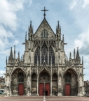
Image taken over from | https://commons.wikimedia.org/wiki/File:Saint-Urbain_de_Troyes,_West_Facade_Semi-HDR_20140509_5.jpg |
Image has been uploaded | by biroto-Redaktion on 22 Apr 2020
|
Information about copyright | |
|---|---|
Rights owner | |
Rights characteristic / license | by-sa: CREATIVE COMMONS Attribution-ShareAlike |
Link to the description of the license | |
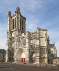
Image taken over from | https://commons.wikimedia.org/wiki/File:TroyesF10_cathedrale_IMF9677.jpg |
Image has been uploaded | by biroto-Redaktion on 22 Apr 2020
|
Information about copyright | |
|---|---|
Rights owner | |
Rights characteristic / license | cc0: Public Domain no Rights reserved |
Link to the description of the license | |
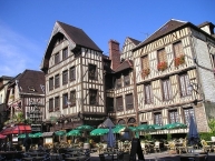
Image taken over from | https://commons.wikimedia.org/wiki/File:Troyes_centre_ville1.JPG |
Image has been uploaded | by biroto-Redaktion on 22 Apr 2020
|
Information about copyright | |
|---|---|
Rights owner | |
Rights characteristic / license | by-sa: CREATIVE COMMONS Attribution-ShareAlike |
Link to the description of the license | |
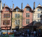
Image taken over from | https://commons.wikimedia.org/wiki/File:Troyes_maisons_rue_Emile_Zola_DSC_0365.JPG |
Image has been uploaded | by biroto-Redaktion on 22 Apr 2020
|
Troyes ist eine Stadt in Frankreich und der Verwaltungssitz des Départements Aube in der Region Champagne-Ardenne. Sie liegt am Ufer der Seine.
Hintergrund
Troyes wurde vom keltischen Stamm der Tricassen gegründet und dann unter den Römern ein wichtiger Handelsort der Region. Bei den Römern hieß die Stadt Augustobona Tricassium. Schon im 4. Jahrhundert wurde die Stadt zum Bischofssitz erhoben. Westlich von Troyes fand im Jahr 451 die Schlacht auf den Katalaunischen Feldern zwischen den Hunnen unter Attila und weströmischen Truppen unter Aetius. Im Hundertjährigen Krieg lag Troyes im englischen Gebiet und hier wurde im Jahr 1420 der Vertrag von Troyes zwischen England, Frankreich und Burgund unterschrieben, der die Thronfolge nach dem Tode von Karl VI. regeln sollte. Da der Krieg 9 Jahre später zu Ende ging und der französische Thronfolger sich durchsetzen konnte, hatte der Vertrag keine größeren Auswirkungen auf die spätere Geschichte. Nach dem Krieg erholte sich die Stadt und sie wurde zu einem wichtigen Zentrum der Textilindustrie. Der Aufschwung wurde noch einmal unterbrochen, als mit dem Ende des Ediktes von Nantes viele Hugenotten die Stadt verließen. Bis heute werden in Troyes Textilien für Lacoste gefertigt.
Sehenswürdigkeiten
Bauwerke
- Historische Fachwerkaltstadt. Mit typisch französischen Baumustern (maisons à colombage).
Kirchen, Moscheen, Synagogen, Tempel
Information about copyright | |
|---|---|
Rights characteristic / license | by-sa: CREATIVE COMMONS Attribution-ShareAlike |
Link to the description of the license | |
Input taken over from: |
Wikivoyage-Bearbeiter, 'Troyes', Wikivoyage, Freie Reiseinformationen rund um die Welt, 21. März 2020, 15:25 UTC, https://de.wikivoyage.org/w/index.php?title=Troyes&oldid=1282037 [abgerufen am 22. April 2020 ] |
taken over / edited on | 22 Apr 2020
|
taken over / edited by |
|
![]()