Radweg Køge - Masnedsund
Nr. des Radweges 56
Aktionen
![]()
Bitte warten - Kartendaten werden geladen
Erstellt am 02.02.2013,
zuletzt geändert von biroto-Redaktion am 30.12.2020
Aktionen
Strecken-Merkmale
Gesamtlänge in km
69
Informationen zu Rechten an den GPS-Track-Daten | |
|---|---|
Rechte-Inhaber | OpenStreetMap and Contributors + biroto-Redaktion (biroto.eu) |
Rechte-Ausprägung / Lizenz | Enthält Daten von OpenStreetMap, die hier unter der Open Database License(ODbL) verfügbar gemacht werden |
Link zur Rechtebeschreibung | |
gpx-Datei übernommen aus | |
gpx-Datei hochgeladen | durch biroto-Redaktion am 30.12.2020
|
Gesamtzahl Trackpoints
843
Trackpoint-Dichte per km
12
Endorte
Start
Køge, Region Zealand, DK (2 m NHN)
Ziel
Masnedø, Region Zealand, DK (1 m NHN)
Wegweisung
|
Fahrradfreundliche Unterkünfte, Sehenswertes und Infrastruktur
Name u. Anschrift
Breite / Länge
Tel.
Fax.
Mobile
Art d. Unterkunft
Radler-freund-lichkeit
Strecken-km
km zur Strecke
Höhe
0 km
0,5 km
11 m
0 km
1,1 km
5 m
Informationen zu Urheber-Rechten | |
|---|---|
Rechte-Inhaber | |
Rechte-Ausprägung / Lizenz | by-sa: CREATIVE COMMONS Namensnennung, Weitergabe unter gleichen Bedingungen |
Link zur Rechtebeschreibung | |
Bild übernommen aus | en.wikipedia.org/wiki/File:Køge_-_statue_af_Frederik_7._-_Torvet.jpg |
Bild hochgeladen | durch biroto-Redaktion am 15.09.2012
|
Informationen zu Urheber-Rechten | |
|---|---|
Rechte-Inhaber | |
Rechte-Ausprägung / Lizenz | by-sa: CREATIVE COMMONS Namensnennung, Weitergabe unter gleichen Bedingungen |
Link zur Rechtebeschreibung | |
Bild übernommen aus | |
Bild hochgeladen | durch biroto-Redaktion am 15.09.2012
|
Informationen zu Urheber-Rechten | |
|---|---|
Rechte-Inhaber | |
Rechte-Ausprägung / Lizenz | by-sa: CREATIVE COMMONS Namensnennung, Weitergabe unter gleichen Bedingungen |
Link zur Rechtebeschreibung | |
Bild übernommen aus | da.wikipedia.org/wiki/Fil:Køge_-_Richters_Gæstgivergård,_Vestergade.jpg |
Bild hochgeladen | durch biroto-Redaktion am 15.09.2012
|
Informationen zu Urheber-Rechten | |
|---|---|
Rechte-Inhaber | |
Rechte-Ausprägung / Lizenz | by-sa: CREATIVE COMMONS Namensnennung, Weitergabe unter gleichen Bedingungen |
Link zur Rechtebeschreibung | |
Bild übernommen aus | |
Bild hochgeladen | durch biroto-Redaktion am 15.09.2012
|
Køge([ˈkøːə] or [ˈkøːjə], older spelling Kjøge) is a seaport on the coast of Køge Bugt (Bay of Køge) 39 km southwest of Copenhagen. It is the principal town and seat of Køge Municipality,Region Sjælland, Denmark. In 2012, the urban area had a population of about 35,300.
The natural harbour and strategic location have given Køge a long history as a market town. Today, that past is witnessed by a well-preserved old town centre with many half-timbered houses.
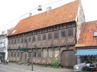
The historical architecture of the town centre is one of the major attractions of Køge. The oldest dated half-timbered house in Denmark, which is also the oldest dated non-nobility and non-religious building of the nordic countries, can be found in Køge. It was built in 1527. Originally a section of a row of hovels, it is now a part of the public library. Pictures can be found in the gallery.
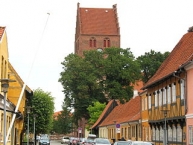
Near the house is Sankt Nicolai Church. The tower of the church contains a lighthouse, the first to be built in Denmark.
Køge's town hall dates from 1552 and is the oldest town hall in Denmark still in use as such.
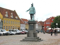
Køge Torv, the market square, is, with an area of almost 1 hectare, the largest town square in Denmark outside Copenhagen and the largest and best-preserved medieval town square in Denmark. There are fair days on the square Wednesday and Saturday.
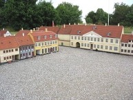
Kjøge Miniby (Kjøge Mini-Town) is a historically correct model of the town from the year 1865 – built to a scale of 1:10.
Informationen zu Urheber-Rechten | |
|---|---|
Rechte-Ausprägung / Lizenz | by-sa: CREATIVE COMMONS Namensnennung, Weitergabe unter gleichen Bedingungen |
Link zur Rechtebeschreibung | |
Text(e) übernommen von: |
Wikipedia contributors, 'Køge', Wikipedia, The Free Encyclopedia, 5 September 2012, 09:19 UTC, http://en.wikipedia.org/w/index.php?title=K%C3%B8ge&oldid=510889336 [accessed 15 September 2012] |
übernommen / bearbeitet am | 15.09.2012
|
übernommen / bearbeitet durch |
|
5 km
2,0 km
13 m
Informationen zu Urheber-Rechten | |
|---|---|
Rechte-Inhaber | |
Rechte-Ausprägung / Lizenz | by-sa: CREATIVE COMMONS Namensnennung, Weitergabe unter gleichen Bedingungen |
Link zur Rechtebeschreibung | |
Bild übernommen aus | en.wikipedia.org/wiki/File:Vallø_Castle_(Vallø_Castle_(Stevns_Municipality).jpg |
Bild hochgeladen | durch biroto-Redaktion am 15.09.2012
|
Informationen zu Urheber-Rechten | |
|---|---|
Rechte-Inhaber | |
Rechte-Ausprägung / Lizenz | by-sa: CREATIVE COMMONS Namensnennung, Weitergabe unter gleichen Bedingungen |
Link zur Rechtebeschreibung | |
Bild übernommen aus | |
Bild hochgeladen | durch biroto-Redaktion am 15.09.2012
|
Informationen zu Urheber-Rechten | |
|---|---|
Rechte-Inhaber | |
Rechte-Ausprägung / Lizenz | by-sa: CREATIVE COMMONS Namensnennung, Weitergabe unter gleichen Bedingungen |
Link zur Rechtebeschreibung | |
Bild übernommen aus | |
Bild hochgeladen | durch biroto-Redaktion am 15.09.2012
|
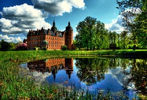
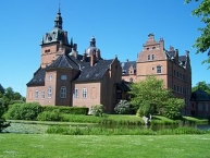
Vallø Castle (Danish: Vallø Slot) is a manor house located 7 km south of Køge , in Stevns Municipality, on the island of Zealand in Denmark. It now serves as a residence for unmarried, widowed and divorced women of noble decent.
Vallø consists of four wings with robust towers and is surrounded by a moat. The south wing, with its robust corner towers, and the south end of the west wing were built from 1580 to 1586 by Mette Rosenkrantz, one of the richest women in Denmark of her day. In Christen Skeel's time of ownership, from 1638 to 1659, the castle was expanded to three storeys and the west wing extended. The north wing was built by Johan Cornelius Krieger in 1721.
A three-winged building designed by Lauritz de Thurah was built in the courtyard from 1735 to 1738. The surviving central wing expanded with an extra storey by Georg David Anthon in 1765.
The castle was devastated by fire in 1893 but restored largely to its old design by Hans Jørgen Holm between 1893 and 1904.
The park was turned into a Romantic landscape garden in 1830 but retains elements from the former French gardens from the 1720s. I large flower park was founded in 1960 but it has later been disbanded.
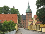
Next to castle and its park there is a cluster of historic houses arranged around a street known as Vallø Castle Street (da. Vallø Slotsgade). Vallø Castle Inn received a royal privilege in 1784. The estate also owns a variety of other houses spread out across the surrounding countryside.
Informationen zu Urheber-Rechten | |
|---|---|
Rechte-Ausprägung / Lizenz | by-sa: CREATIVE COMMONS Namensnennung, Weitergabe unter gleichen Bedingungen |
Link zur Rechtebeschreibung | |
Text(e) übernommen von: |
Wikipedia contributors, 'Vallø Castle', Wikipedia, The Free Encyclopedia, 4 September 2012, 18:36 UTC, http://en.wikipedia.org/w/index.php?title=Vall%C3%B8_Castle&oldid=510794975 [accessed 15 September 2012] |
übernommen / bearbeitet am | 15.09.2012 - 14.04.2015
|
übernommen / bearbeitet durch |
|
27 km
0,1 km
41 m
Informationen zu Urheber-Rechten | |
|---|---|
Rechte-Inhaber | |
Rechte-Ausprägung / Lizenz | by-sa: CREATIVE COMMONS Namensnennung, Weitergabe unter gleichen Bedingungen |
Link zur Rechtebeschreibung | |
Bild übernommen aus | |
Bild hochgeladen | durch biroto-Redaktion am 23.05.2017
|
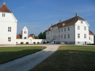
Jomfruens Egede is a manor house located three kilometres north-west of Faxe , a small town some 40 km south of Copenhagen, Denmark. It owes its current appearance to Sophie Amalie Moth who in the late 18th century altered it with the assistance of Caspar Frederik Harsdorff and Joseph Christian Lillie. The National Museum of Denmark has described it as possibly the finest example from the period.
Jomfruens Egede traces its history back to 1346 when it was owned by Uffe Pedersen Neb, a loyal supporter of King Valdemar IV, and known as Egedegaard. Etymologically, Egede- derives from an old form 'large oak forest' while -gaard means 'farm' or 'manor'. Its name, which means 'Egede of the Lady' refers to two unmarried noble women, Ermegaard and Birgitte Bille, who in 1542 inherited the estate from their father.
Architecture
Designed in the Neoclassical style, Jomfruens Egede consists of two parallel wings which to the south border on the churchyard of Østre Egede Church.
The house is particularly noted for its interiors which the National Museum of Denmark has described as "possibly the finest example of Danish interior design and furnishings of the late 18th century".
Informationen zu Urheber-Rechten | |
|---|---|
Rechte-Ausprägung / Lizenz | by-sa: CREATIVE COMMONS Namensnennung, Weitergabe unter gleichen Bedingungen |
Link zur Rechtebeschreibung | |
Text(e) übernommen von: |
Wikipedia contributors, 'Jomfruens Egede', Wikipedia, The Free Encyclopedia, 21 November 2016, 17:41 UTC, <https://en.wikipedia.org/w/index.php?title=Jomfruens_Egede&oldid=750759277> [accessed 23 May 2017] |
übernommen / bearbeitet am | 23.05.2017
|
übernommen / bearbeitet durch |
|
51 km
2,1 km
0 m
![]()


