
Radweg Véloroute du Thouet
Aktionen
![]()
Bitte warten - Kartendaten werden geladen
Erstellt am 09.07.2012,
zuletzt geändert von biroto-Redaktion am 06.12.2020
Aktionen
Strecken-Merkmale
Gesamtlänge in km
154
Informationen zu Rechten an den GPS-Track-Daten | |
|---|---|
Rechte-Inhaber | OpenStreetMap and Contributors + biroto-Redaktion (biroto.eu) |
Rechte-Ausprägung / Lizenz | Enthält Daten von OpenStreetMap, die hier unter der Open Database License(ODbL) verfügbar gemacht werden |
Link zur Rechtebeschreibung | |
gpx-Datei übernommen aus | |
gpx-Datei hochgeladen | durch biroto-Redaktion am 06.12.2020
|
Gesamtzahl Trackpoints
3.132
Trackpoint-Dichte per km
20
Endorte
Start
Saint-Hilaire-de-Voust, Pays de la Loire, FR (100 m NHN)
Ziel
Saumur, Pays de la Loire, FR (26 m NHN)
Fahrradfreundliche Unterkünfte, Sehenswertes und Infrastruktur
Name u. Anschrift
Breite / Länge
Tel.
Fax.
Mobile
Art d. Unterkunft
Radler-freund-lichkeit
Strecken-km
km zur Strecke
Höhe
42 km
0,2 km
176 m
Informationen zu Urheber-Rechten | |
|---|---|
Rechte-Inhaber | |
Rechte-Ausprägung / Lizenz | by-sa: CREATIVE COMMONS Namensnennung, Weitergabe unter gleichen Bedingungen |
Link zur Rechtebeschreibung | |
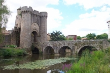
Bild übernommen aus | https://commons.wikimedia.org/wiki/File:Saint-Jacques_Gate_Parthenay.jpg |
Bild hochgeladen | durch ThimbleU am 05.10.2018
|
Informationen zu Urheber-Rechten | |
|---|---|
Rechte-Inhaber | |
Rechte-Ausprägung / Lizenz | by-sa: CREATIVE COMMONS Namensnennung, Weitergabe unter gleichen Bedingungen |
Link zur Rechtebeschreibung | |
Bild übernommen aus | https://commons.wikimedia.org/wiki/File:Parthenay_porte_de_la_citadelle_4.JPG |
Bild hochgeladen | durch ThimbleU am 05.10.2018
|
Informationen zu Urheber-Rechten | |
|---|---|
Rechte-Inhaber | |
Rechte-Ausprägung / Lizenz | by-sa: CREATIVE COMMONS Namensnennung, Weitergabe unter gleichen Bedingungen |
Link zur Rechtebeschreibung | |
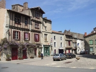
Bild übernommen aus | https://commons.wikimedia.org/wiki/File:Rue_de_la_Vau_Saint-Jaques_Parthenay.jpg |
Bild hochgeladen | durch ThimbleU am 05.10.2018
|
Informationen zu Urheber-Rechten | |
|---|---|
Rechte-Inhaber | |
Rechte-Ausprägung / Lizenz | by-sa: CREATIVE COMMONS Namensnennung, Weitergabe unter gleichen Bedingungen |
Link zur Rechtebeschreibung | |
Bild übernommen aus | |
Bild hochgeladen | durch ThimbleU am 05.10.2018
|
Parthenay (pronounced [paʁ.tɛ.nɛ]) is an ancient fortified town and commune in the Deux-Sèvres department of the Nouvelle-Aquitaine region in western France. It is sited on a rocky spur that is surrounded on two sides by the River Thouet ![]() .
.
Each July, Parthenay hosts the Festival Ludique International de Parthenay, otherwise known as the Festival de Jeux or FLIP, in which the town's streets and squares are filled with games of many types. The shorter indoor FLIP d'hiver runs in November.
Understand
Legend has it that Parthenay was created with a wave of the fairy Melusine's wand. However the name of Parthenay first appears in written records at the beginning of the 11th century and there is no evidence of previous significant human occupation in the Middle Ages.
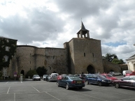
The castle, situated on an easily defended site at the tip of the rocky promontory surrounded by the loop of the river, was built in the 13th century. At the same time the outer fortifications protecting the citadel, and the town itself, were completed.
Economically, Parthenay benefited by being on one of the branches of the Way of St. James, the mediaeval pilgrimage route to Santiago de Compostella in Spain. The main fortified gate, by which pilgrims would enter the town, still bears the name of Saint Jacques (the French name for Saint James).
Historically, Parthenay was considered the capital of the Gâtine Vendéenne, the hilly and wooded area that occupies the centre of the current department of Deux-Sèvres and is quite different in character to the plains to the south, around Niort. Because of the nature of the land, the area became known for the breeding of cattle, and the Parthenais breed is named after the town.
It was not until the 19th century that the town expanded beyond its walls. Wide boulevards and squares were constructed following the line of the old town wall and moat to the east of the town. Beyond these, the railway station was built in 1880, and new districts and industries grew up around this.
See
The medieval centre of Parthenay contains a number of sights, including:
- The Town Walls, which are particularly visible to the west and north, where they sit on top of and incorporate a high granite outcrop. The outer town walls to the east and south have largely been removed, although their course can still be inferred from the wide boulevards that replaced them, but the eastern wall of the inner citadel can still be seen, rising above the Rue de la Vau Saint-Jaques.
- The Porte St-Jacques and Pont St-Jacques form the entry into the walled town from the north. The bridge crosses the River Thouet before passing through the heavily fortified gateway, which was built in the early 13th century. This would have been the entry into the town used by the pilgrims. Today's visitors can reach the top of the gatehouse, which provides views over the river and lower part of the town.
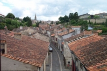
- The Rue de la Vau Saint-Jaques is a narrow street lined with medieval timber-framed houses, with vegetable plots climbing the slopes that rise above either side of the street. At one time this would have been the main pilgrimage route from the Porte St-Jacques up to the town centre, and was occupied by weavers. Many of the houses retain the wooden ground floor shutters that folded down to form a stall.
- The Porte de l'Horloge is the fortified gateway into the citadel from the town centre, and dates from the 13th century. In 1454, a bell was added to toll the hours, and subsequently clock faces were added to the tower.
- The Église Sainte-Croix is a romanesque church within the citadel, adjacent to the mairie and law courts. It was founded in the 11th century.
- The Église Saint-Laurent is a parish church in the centre of the town which is believed to date from the early 11th century. It has been rebuilt several times and has both romanesque and gothic features.
- The Chapelle des Cordeliers is a 13th-century chapel constructed by the Order of St Francis, known in France as the Cordeliers for the chord they wore at their waist. A small side chapel dating from the 16th century houses a fine renaissance altarpiece.
- The sculpture "La Rivière" by Pierre Charles Lenoir is held in Parthenay Mairie.
Informationen zu Urheber-Rechten | |
|---|---|
Rechte-Ausprägung / Lizenz | by-sa: CREATIVE COMMONS Namensnennung, Weitergabe unter gleichen Bedingungen |
Link zur Rechtebeschreibung | |
Text(e) übernommen von: |
Wikipedia contributors, 'Parthenay', Wikipedia, The Free Encyclopedia, 30 January 2018, 16:23 UTC, <https://en.wikipedia.org/w/index.php?title=Parthenay&oldid=823158881> [accessed 5 October 2018] |
übernommen / bearbeitet am | 05.10.2018
|
übernommen / bearbeitet durch |
|
71 km
3,7 km
140 m
74 km
0,2 km
81 m
Informationen zu Urheber-Rechten | |
|---|---|
Rechte-Inhaber | |
Rechte-Ausprägung / Lizenz | by-sa: CREATIVE COMMONS Namensnennung, Weitergabe unter gleichen Bedingungen |
Link zur Rechtebeschreibung | |
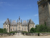
Bild übernommen aus | https://commons.wikimedia.org/wiki/File:Château_de_Saint-Loup-sur-Thouet_02.jpg |
Bild hochgeladen | durch biroto-Redaktion am 06.12.2020
|
Informationen zu Urheber-Rechten | |
|---|---|
Rechte-Inhaber | |
Rechte-Ausprägung / Lizenz | by-sa: CREATIVE COMMONS Namensnennung, Weitergabe unter gleichen Bedingungen |
Link zur Rechtebeschreibung | |
Bild übernommen aus | https://commons.wikimedia.org/wiki/File:Hôtel_du_Parquet_(Saint-Loup-sur-Thouet)_01.jpg |
Bild hochgeladen | durch biroto-Redaktion am 06.12.2020
|
Die französische Gemeinde Saint-Loup-Lamairé liegt im Département Deux-Sèvres in der Region Nouvelle-Aquitaine. Sie gehört zum Kanton Le Val de Thouet und hat 986 Einwohner (Stand 2017).
Sehenswürdigkeiten
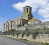
- Das wahrscheinlich von einem Jean oder Amaury de Dercé erbaute Schloss stammt aus dem 17. Jahrhundert (frz.: Château de Saint-Loup-sur-Thouet). Ein Turm davon ist 200 Jahre älter. Ein Vorgängerbauwerk soll im XI. Jahrhundert von einem Herrn Drogon errichtet worden sein.
- Stadtmauer umgibt viele historische Gebäude
- Kirche Notre-Dame de l'Assomption
Informationen zu Urheber-Rechten | |
|---|---|
Rechte-Ausprägung / Lizenz | by-sa: CREATIVE COMMONS Namensnennung, Weitergabe unter gleichen Bedingungen |
Link zur Rechtebeschreibung | |
Text(e) übernommen von: |
Seite „Saint-Loup-Lamairé“. In: Wikipedia, Die freie Enzyklopädie. Bearbeitungsstand: 24. September 2020, 08:56 UTC. URL: https://de.wikipedia.org/w/index.php?title=Saint-Loup-Lamair%C3%A9&oldid=203934812 (Abgerufen: 6. Dezember 2020, 17:06 UTC) |
übernommen / bearbeitet am | 06.12.2020
|
übernommen / bearbeitet durch |
|
80 km
0,1 km
109 m
109 km
0,1 km
91 m
Öffnungszeiten
From 01/10/2018 to 31/12/2018,
- Tuesday from 10h to 12h and from 14h to 18h
- Wednesday from 10h to 12h and from 14h to 18h
- Thursday from 14h to 18h
- Friday from 10h to 12h and from 14h to 18h
Sprachen:
française
![]()