
Radweg Voie Verte de Saint Malo à Arzal
Nr. des Radweges V42
Aktionen
![]()
Bitte warten - Kartendaten werden geladen
Erstellt am 19.05.2012,
zuletzt geändert von biroto-Redaktion am 29.03.2024
Aktionen
Strecken-Merkmale
Gesamtlänge in km
243
Informationen zu Rechten an den GPS-Track-Daten | |
|---|---|
Rechte-Inhaber | OpenStreetMap and Contributors + biroto-Redaktion (biroto.eu) |
Rechte-Ausprägung / Lizenz | Enthält Daten von OpenStreetMap, die hier unter der Open Database License(ODbL) verfügbar gemacht werden |
Link zur Rechtebeschreibung | |
gpx-Datei übernommen aus | |
gpx-Datei hochgeladen | durch biroto-Redaktion am 29.03.2024
|
Gesamtzahl Trackpoints
3.957
Trackpoint-Dichte per km
16
Endorte
Start
Dinard, Bretagne, FR (32 m NHN)
Ziel
Camoël, Bretagne, FR (15 m NHN)
Fahrradfreundliche Unterkünfte, Sehenswertes und Infrastruktur
Name u. Anschrift
Breite / Länge
Tel.
Fax.
Mobile
Art d. Unterkunft
Radler-freund-lichkeit
Strecken-km
km zur Strecke
Höhe
0 km
4,9 km
27 m
0 km
3,8 km
14 m
0 km
3,3 km
5 m
Öffnungszeiten
From 4 April to 27 September from 9:30 every 40 minutes a departure to Dinard until 17:50.
Additional departures on Saturdays at 9:00, 18:30 and 19:10
From 11 July to 30 August additional departures.
Ticket about 10,40 € per adault and bicycle.
0 km
3,6 km
14 m
Informationen zu Urheber-Rechten | |
|---|---|
Rechte-Inhaber | |
Rechte-Ausprägung / Lizenz | by-sa: CREATIVE COMMONS Namensnennung, Weitergabe unter gleichen Bedingungen |
Link zur Rechtebeschreibung | |
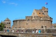
Bild übernommen aus | commons.wikimedia.org/wiki/File:Chateau-de-Saint-Malo-DSC_6.jpg |
Bild hochgeladen | durch biroto-Redaktion am 25.04.2015
|
Informationen zu Urheber-Rechten | |
|---|---|
Rechte-Inhaber | |
Rechte-Ausprägung / Lizenz | by-sa: CREATIVE COMMONS Namensnennung, Weitergabe unter gleichen Bedingungen |
Link zur Rechtebeschreibung | |
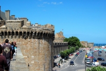
Bild übernommen aus | commons.wikimedia.org/wiki/File:Remparts-st-malo-cote-port-.jpg |
Bild hochgeladen | durch biroto-Redaktion am 25.04.2015
|
Informationen zu Urheber-Rechten | |
|---|---|
Rechte-Inhaber | |
Rechte-Ausprägung / Lizenz | by-sa: CREATIVE COMMONS Namensnennung, Weitergabe unter gleichen Bedingungen |
Link zur Rechtebeschreibung | |
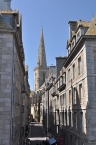
Bild übernommen aus | commons.wikimedia.org/wiki/File:Saint-Malo_-_walled_city_04.jpg |
Bild hochgeladen | durch biroto-Redaktion am 25.04.2015
|
Informationen zu Urheber-Rechten | |
|---|---|
Rechte-Inhaber | |
Rechte-Ausprägung / Lizenz | by-sa: CREATIVE COMMONS Namensnennung, Weitergabe unter gleichen Bedingungen |
Link zur Rechtebeschreibung | |
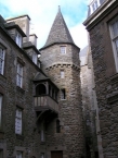
Bild übernommen aus | commons.wikimedia.org/wiki/File:Saint-Malo_Maison_Anne_de_Bretagne.jpg |
Bild hochgeladen | durch biroto-Redaktion am 25.04.2015
|
Saint-Malo (French pronunciation: [sɛ̃.ma.lo]; Gallo : Saent-Malô; Breton: Sant-Maloù) is a walled port city in Brittany in northwestern France on the English Channel.
Traditionally with an independent streak, Saint-Malo was in the past notorious for piracy. Today it is a major tourist destination, with many ancient, attractive buildings.
Saint-Malo during the Middle Ages was a fortified island at the mouth of the Rance River ![]() , controlling not only the estuary but the open sea beyond. The promontory fort of Aleth, south of the modern centre in what is now the Saint-Servan
, controlling not only the estuary but the open sea beyond. The promontory fort of Aleth, south of the modern centre in what is now the Saint-Servan ![]() district, commanded approaches to the Rance even before the Romans, but modern Saint-Malo traces its origins to a monastic settlement founded by Saint Aaron and Saint Brendan early in the 6th century.
district, commanded approaches to the Rance even before the Romans, but modern Saint-Malo traces its origins to a monastic settlement founded by Saint Aaron and Saint Brendan early in the 6th century.
St. Malo is the setting of Marie de France's poem "Laustic", an 11th-century love story. Saint-Malo had a tradition of asserting its autonomy in dealings with the French authorities and even with the local Breton authorities. From 1590–1593, Saint-Malo declared itself to be an independent republic, taking the motto "not French, not Breton, but Malouins".
Saint-Malo became notorious as the home of the corsairs, French privateers and sometimes pirates. In the 19th century this "piratical" notoriety was portrayed in Jean Richepin's play Le flibustier and in César Cui's eponymous opera. The corsairs of Saint-Malo not only forced English ships passing up the Channel to pay tribute, but also brought wealth from further afield. In 1758 the Raid on St Malo ![]() saw a British expedition land intending to capture the town. However the British made no attempt on St Malo, and instead occupied the nearby town of St Servan
saw a British expedition land intending to capture the town. However the British made no attempt on St Malo, and instead occupied the nearby town of St Servan ![]() where they destroyed 30 privateers before departing.
where they destroyed 30 privateers before departing.
In World War II, during fighting in late August and early September 1944, the historic walled city of Saint-Malo was almost totally destroyed by U.S. shelling and bombing plus British naval gunfire. Saint-Malo was rebuilt over a 12-year period from 1948-1960.
Sites of interest
Now inseparably attached to the mainland, Saint-Malo is the most visited place in Brittany. Sites of interest include:
- The walled city (La Ville Intra-Muros)
- ⊙ The château of Saint-Malo, part of which is now the town museum.
- ⊙ The Solidor Tower
 in Saint-Servan is a 14th-century building that holds a collection tracing the history of voyages around Cape Horn . Many scale models, nautical instruments and objects made by the sailors during their crossing or brought back from foreign ports invoke thoughts of travel aboard extraordinary tall ships at the end of the 19th and the beginning of the 20th century.
 - The tomb of the writer Chateaubriand on the Ile du Grand Bé
- ⊙ The Petit Bé
- ⊙ The Cathedral of St. Vincent (Saint-Malo Cathedral )
- The Privateer's House ("La Demeure de Corsaire"), a ship-owner's town house built in 1725, shows objects from the history of privateering, weaponry and ship models.
- ⊙ The Great Aquarium Saint-Malo , one of the major aquaria in France.
- The labyrinthe du Corsaire, (an attraction park in Saint Malo)
- The Pointe de la Varde, Natural Park.
- The City of Alet, in front of Saint Malo Intra Muros.
- ⊙Fort National
- ⊙Fort de la Conchée
Informationen zu Urheber-Rechten | |
|---|---|
Rechte-Ausprägung / Lizenz | by-sa: CREATIVE COMMONS Namensnennung, Weitergabe unter gleichen Bedingungen |
Link zur Rechtebeschreibung | |
Text(e) übernommen von: |
Wikipedia contributors, 'Saint-Malo', Wikipedia, The Free Encyclopedia, 25 March 2015, 17:24 UTC, http://en.wikipedia.org/w/index.php?title=Saint-Malo&oldid=653484013 |
übernommen / bearbeitet am | 25.04.2015 - 13.03.2022
|
übernommen / bearbeitet durch |
|
0 km
1,1 km
20 m
Öffnungszeiten
From 4 April to 27 September from 9:50 every 40 minutes a departure to Dinard until 18:10.
Additional departures on Saturdays at 9:15, 18:50 and 19:30
From 11 July to 30 August additional departures.
Ticket about 10,40 € per adault and bicycle.
![]()