
Radweg Cockermouth nach Tynemouth
Nr. des Radweges 10
Aktionen
![]()
Bitte warten - Kartendaten werden geladen
Erstellt am 17.10.2012,
zuletzt geändert von biroto-Redaktion am 16.10.2023
Aktionen
Strecken-Merkmale
Gesamtlänge in km
244
Informationen zu Rechten an den GPS-Track-Daten | |
|---|---|
Rechte-Inhaber | OpenStreetMap and Contributors + biroto-Redaktion (biroto.eu) |
Rechte-Ausprägung / Lizenz | Enthält Daten von OpenStreetMap, die hier unter der Open Database License(ODbL) verfügbar gemacht werden |
Link zur Rechtebeschreibung | |
gpx-Datei übernommen aus | |
gpx-Datei hochgeladen | durch biroto-Redaktion am 16.10.2023
|
Gesamtzahl Trackpoints
3.983
Trackpoint-Dichte per km
16
Endorte
Start
Cockermouth, ENG, GB (51 m NHN)
Ziel
North Shields, ENG, GB (14 m NHN)
Fahrradfreundliche Unterkünfte, Sehenswertes und Infrastruktur
Name u. Anschrift
Breite / Länge
Tel.
Fax.
Mobile
Art d. Unterkunft
Radler-freund-lichkeit
Strecken-km
km zur Strecke
Höhe
52 km
0,2 km
24 m
Informationen zu Urheber-Rechten | |
|---|---|
Rechte-Inhaber | en.wikipedia.org/wiki/User:Diliff |
Rechte-Ausprägung / Lizenz | by-sa: CREATIVE COMMONS Namensnennung, Weitergabe unter gleichen Bedingungen |
Link zur Rechtebeschreibung | |
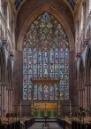
Bild übernommen aus | https://commons.wikimedia.org/wiki/File:Carlisle_Cathedral_Tracery,_Cumbria,_UK_-_Diliff.jpg |
Bild hochgeladen | durch biroto-Redaktion am 08.05.2017
|
Informationen zu Urheber-Rechten | |
|---|---|
Rechte-Inhaber | |
Rechte-Ausprägung / Lizenz | cc0: Public Domain keine Rechte vorbehalten |
Link zur Rechtebeschreibung | |
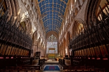
Bild übernommen aus | https://commons.wikimedia.org/wiki/File:Carlisle_Cathedral_Interior.jpg |
Bild hochgeladen | durch biroto-Redaktion am 08.05.2017
|
Informationen zu Urheber-Rechten | |
|---|---|
Rechte-Inhaber | |
Rechte-Ausprägung / Lizenz | by: CREATIVE COMMONS Namensnennung |
Link zur Rechtebeschreibung | |
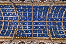
Bild übernommen aus | https://commons.wikimedia.org/wiki/File:Carlisle_Cathedral_Ceiling_(7167745504).jpg |
Bild hochgeladen | durch biroto-Redaktion am 08.05.2017
|
Informationen zu Urheber-Rechten | |
|---|---|
Rechte-Inhaber | |
Rechte-Ausprägung / Lizenz | by-sa: CREATIVE COMMONS Namensnennung, Weitergabe unter gleichen Bedingungen |
Link zur Rechtebeschreibung | |
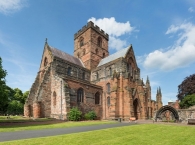
Bild übernommen aus | https://commons.wikimedia.org/wiki/File:Carlisle_Cathedral_Exterior,_Cumbria,_UK_-_Diliff.jpg |
Bild hochgeladen | durch biroto-Redaktion am 08.05.2017
|
The Cathedral Church of the Holy and Undivided Trinity, otherwise called Carlisle Cathedral, is the seat of the Anglican Bishop of Carlisle. It is located in Carlisle ![]() , in Cumbria, North West England. It was founded as an Augustinian priory and became a cathedral in 1133.
, in Cumbria, North West England. It was founded as an Augustinian priory and became a cathedral in 1133.
Carlisle, because of heavy losses to its fabric, is the second smallest (after Oxford ![]() ), of England's ancient cathedrals. Its notable features include some fine figurative stone carving, a set of medieval choir stalls and the largest window in the Flowing Decorated Gothic style in England.
), of England's ancient cathedrals. Its notable features include some fine figurative stone carving, a set of medieval choir stalls and the largest window in the Flowing Decorated Gothic style in England.
Informationen zu Urheber-Rechten | |
|---|---|
Rechte-Ausprägung / Lizenz | by-sa: CREATIVE COMMONS Namensnennung, Weitergabe unter gleichen Bedingungen |
Link zur Rechtebeschreibung | |
Text(e) übernommen von: |
Wikipedia contributors, 'Carlisle Cathedral', Wikipedia, The Free Encyclopedia, 20 March 2017, 16:40 UTC, <https://en.wikipedia.org/w/index.php?title=Carlisle_Cathedral&oldid=771276912> [accessed 8 May 2017] |
übernommen / bearbeitet am | 08.05.2017
|
übernommen / bearbeitet durch |
|
Öffnungszeiten
The Cathedral is usually open daily from 7.30am to 6.15pm Monday to Saturday, and 7.30am to 5.00pm on Sunday.
For service times please see the section on Daily Services or the Cathedral diary.
Please note that the Cathedral is regularly used for a variety of public and private events which may not be highlighted in the website diary.
52 km
0,0 km
18 m
Informationen zu Urheber-Rechten | |
|---|---|
Rechte-Inhaber | |
Rechte-Ausprägung / Lizenz | by-sa: CREATIVE COMMONS Namensnennung, Weitergabe unter gleichen Bedingungen |
Link zur Rechtebeschreibung | |
Bild übernommen aus | https://commons.wikimedia.org/wiki/File:Carlisle_Castle_-_geograph.org.uk_-_226268.jpg |
Bild hochgeladen | durch biroto-Redaktion am 08.05.2017
|
Informationen zu Urheber-Rechten | |
|---|---|
Rechte-Inhaber | |
Rechte-Ausprägung / Lizenz | by-sa: CREATIVE COMMONS Namensnennung, Weitergabe unter gleichen Bedingungen |
Link zur Rechtebeschreibung | |
Bild übernommen aus | |
Bild hochgeladen | durch biroto-Redaktion am 08.05.2017
|
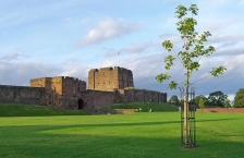
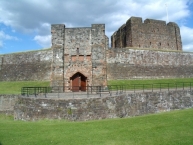
Carlisle Castle is situated in Carlisle ![]() , in the English county of Cumbria, near the ruins of Hadrian's Wall. The castle is over 900 years old and has been the scene of many historical episodes in British history. Given the proximity of Carlisle to the border between England and Scotland, it has been the centre of many wars and invasions. Today the castle is managed by English Heritage and is open to the public. The castle until recently was the administrative headquarters of the former King's Own Royal Border Regiment now county headquarters to the Duke of Lancaster's Regiment and a museum to the regiment is within the castle walls.
, in the English county of Cumbria, near the ruins of Hadrian's Wall. The castle is over 900 years old and has been the scene of many historical episodes in British history. Given the proximity of Carlisle to the border between England and Scotland, it has been the centre of many wars and invasions. Today the castle is managed by English Heritage and is open to the public. The castle until recently was the administrative headquarters of the former King's Own Royal Border Regiment now county headquarters to the Duke of Lancaster's Regiment and a museum to the regiment is within the castle walls.
Informationen zu Urheber-Rechten | |
|---|---|
Rechte-Ausprägung / Lizenz | by-sa: CREATIVE COMMONS Namensnennung, Weitergabe unter gleichen Bedingungen |
Link zur Rechtebeschreibung | |
Text(e) übernommen von: |
Wikipedia contributors, 'Carlisle Castle', Wikipedia, The Free Encyclopedia, 9 March 2017, 03:50 UTC, <https://en.wikipedia.org/w/index.php?title=Carlisle_Castle&oldid=769377149> [accessed 8 May 2017] |
übernommen / bearbeitet am | 08.05.2017
|
übernommen / bearbeitet durch |
|
Öffnungszeiten
April - September 10:00 - 18:00
Last admission 30 minutes before closing time.
243 km
0,7 km
24 m
Informationen zu Urheber-Rechten | |
|---|---|
Rechte-Inhaber | |
Rechte-Ausprägung / Lizenz | by-sa: CREATIVE COMMONS Namensnennung, Weitergabe unter gleichen Bedingungen |
Link zur Rechtebeschreibung | |
Bild übernommen aus | https://commons.wikimedia.org/wiki/File:Arbeia_Roman_Fort_reconstructed_gateway.jpg |
Bild hochgeladen | durch biroto-Redaktion am 13.12.2020
|
Informationen zu Urheber-Rechten | |
|---|---|
Rechte-Inhaber | |
Rechte-Ausprägung / Lizenz | by-sa: CREATIVE COMMONS Namensnennung, Weitergabe unter gleichen Bedingungen |
Link zur Rechtebeschreibung | |
Bild übernommen aus | |
Bild hochgeladen | durch biroto-Redaktion am 13.12.2020
|
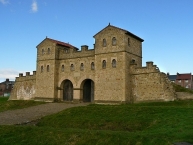
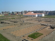
Arbeia was a large Roman fort in South Shields ![]() , Tyne & Wear, England, now ruined, and which has been partially reconstructed. It was first excavated in the 1870s and all modern buildings on the site were cleared in the 1970s. It is managed by Tyne and Wear Museums as Arbeia Roman Fort and Museum.
, Tyne & Wear, England, now ruined, and which has been partially reconstructed. It was first excavated in the 1870s and all modern buildings on the site were cleared in the 1970s. It is managed by Tyne and Wear Museums as Arbeia Roman Fort and Museum.
Original fort
The fort stands on the Lawe Top, overlooking the mouth of the River Tyne. Founded in about AD 160, the Roman Fort guarded the main sea route to Hadrian's Wall. It later became the maritime supply fort for Hadrian's Wall ![]() , and contains the only permanent stone-built granaries yet found in Britain. It was occupied until the Romans left Britain in the 5th century.
, and contains the only permanent stone-built granaries yet found in Britain. It was occupied until the Romans left Britain in the 5th century.
"Arbeia" means the "fort of the Arab troops" referring to the fact that part of its garrison at one time was a squadron of Mesopotamian boatmen from the Tigris, following Emperor Septimius Severus securing the city of Singara in 197. From archaeological evidence, such as the gravestone of Victor, described below, it is known that a squadron of Spanish cavalry, the First Asturian, was stationed there. It was common for forts to be manned by units originally from elsewhere in the empire, though often enough these would assimilate and end up by recruiting locally.
Through the course of history of Arbeia, the fort has had several guises, from a busy cosmopolitan port to being the Roman Emperor Septimius Severus's HQ for a Scottish invasion. It was a huge supply base for the Roman army, having hosted 600 Roman troops, and is said to be the birthplace of the Northumbrian King Oswin.
Museum
Two monuments in the museum at Arbeia testify to the cosmopolitan nature of its shifting population. One commemorates Regina, a British woman of the Catuvellauni tribe (approximately modern Hertfordshire). She was first the slave, then the freedwoman and wife of Barates, an Arab merchant from Palmyra (now part of Syria) who, evidently missing her greatly, set up a gravestone after she died at the age of 30. (Barates himself is buried at the nearby fort at Corbridge ![]() in Northumberland.) The second commemorates Victor, another former slave, freed by Numerianus of the Ala I Asturum, who also arranged his funeral ("piantissime": with all devotion) when Victor died at the age of 20. The stone records that Victor was "of the Moorish nation".
in Northumberland.) The second commemorates Victor, another former slave, freed by Numerianus of the Ala I Asturum, who also arranged his funeral ("piantissime": with all devotion) when Victor died at the age of 20. The stone records that Victor was "of the Moorish nation".
The museum also holds an altarpiece to a previously unknown god and a tablet with the name of the Emperor Severus Alexander (died 235) chiselled off, an example of damnatio memoriae.
Reconstruction
The Reconstruction of the fort has been accomplished using research which was undertaken following excavations, standing where it had originally existed during the Roman occupation of Britain.
A Roman gatehouse, barracks and Commanding Officer's house have been reconstructed on their original foundations. The gatehouse holds many displays related to the history of the fort, and its upper levels provide an overview of the archaeological site.
Informationen zu Urheber-Rechten | |
|---|---|
Rechte-Ausprägung / Lizenz | by-sa: CREATIVE COMMONS Namensnennung, Weitergabe unter gleichen Bedingungen |
Link zur Rechtebeschreibung | |
Text(e) übernommen von: |
Wikipedia contributors, 'Arbeia', Wikipedia, The Free Encyclopedia, 1 October 2020, 21:27 UTC, https://en.wikipedia.org/w/index.php?title=Arbeia&oldid=981364963 [accessed 13 December 2020] |
übernommen / bearbeitet am | 13.12.2020
|
übernommen / bearbeitet durch |
|
Öffnungszeiten
April - Sept. Mon - Fri 10:00 - 17:00, Sat 11:00 - 16:00, Sun 14:00 - 17:00. Oct. - Mar closed.
244 km
0,2 km
31 m
Informationen zu Urheber-Rechten | |
|---|---|
Rechte-Inhaber | |
Rechte-Ausprägung / Lizenz | by-sa: CREATIVE COMMONS Namensnennung, Weitergabe unter gleichen Bedingungen |
Link zur Rechtebeschreibung | |
Bild übernommen aus | https://commons.wikimedia.org/wiki/File:Prieuré_Château_Tynemouth_North_Tyneside_19.jpg |
Bild hochgeladen | durch biroto-Redaktion am 13.12.2020
|
Informationen zu Urheber-Rechten | |
|---|---|
Rechte-Inhaber | Rab Lawrence |
Rechte-Ausprägung / Lizenz | by: CREATIVE COMMONS Namensnennung |
Link zur Rechtebeschreibung | |
Bild übernommen aus | |
Bild hochgeladen | durch biroto-Redaktion am 13.12.2020
|
Informationen zu Urheber-Rechten | |
|---|---|
Rechte-Inhaber | https://commons.wikimedia.org/w/index.php?title=User:Hadrianus1959 |
Rechte-Ausprägung / Lizenz | by-sa: CREATIVE COMMONS Namensnennung, Weitergabe unter gleichen Bedingungen |
Link zur Rechtebeschreibung | |
Bild übernommen aus | https://commons.wikimedia.org/wiki/File:Tynemouth_Priory_Church.jpg |
Bild hochgeladen | durch biroto-Redaktion am 13.12.2020
|
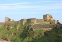
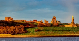
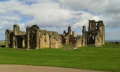
Tynemouth Castle is located on a rocky headland (known as Pen Bal Crag), overlooking Tynemouth ![]() Pier. The moated castle-towers, gatehouse and keep are combined with the ruins of the Benedictine priory where early kings of Northumbria were buried. The coat of arms of the town of Tynemouth still includes three crowns commemorating the tradition that the Priory had been the burial place for three kings.
Pier. The moated castle-towers, gatehouse and keep are combined with the ruins of the Benedictine priory where early kings of Northumbria were buried. The coat of arms of the town of Tynemouth still includes three crowns commemorating the tradition that the Priory had been the burial place for three kings.
Origins of the Priory
Little is known of the early history of the site. Some Roman stones have been found there, but there is no definite evidence that it was occupied by the Romans. The Priory was founded early in the 7th century, perhaps by Edwin of Northumbria. In 651 Oswin, king of Deira was murdered by the soldiers of King Oswiu of Bernicia, and subsequently his body was brought to Tynemouth for burial.[1] He became St Oswin and his burial place became a shrine visited by pilgrims. He was the first of the three kings buried at Tynemouth.
In 792 Osred II, who had been king of Northumbria from 789 to 790 and then deposed, was murdered. He also was buried at Tynemouth Priory.[1] Osred was the second of the three kings buried at Tynemouth. The third king to be buried at Tynemouth was Malcolm III, king of Scotland, who was killed at the Battle of Alnwick in 1093. The king's body was sent north for reburial, in the reign of his son Alexander I, at Dunfermline Abbey, or possibly Iona.
The castle
It is believed that at the time of Robert Mowbray's capture in 1095 there was a castle on the site consisting of earthen ramparts and a wooden stockade. In 1296 the prior of Tynemouth was granted royal permission to surround the monastery with walls of stone, which he did. In 1390 a gatehouse and barbican were added on the landward side of the castle. Much remains of the priory structure as well as the castle gatehouse and walls which are 3200 feet (975 m) in length. The promontory was originally completely enclosed by a curtain wall and towers, but the north and east walls fell into the sea, and most of the south wall was demolished; the west wall, the gatehouse and a section of the south wall (with original wall walk) remain in good condition.
Informationen zu Urheber-Rechten | |
|---|---|
Rechte-Ausprägung / Lizenz | by-sa: CREATIVE COMMONS Namensnennung, Weitergabe unter gleichen Bedingungen |
Link zur Rechtebeschreibung | |
Text(e) übernommen von: |
Wikipedia contributors, 'Tynemouth Castle and Priory', Wikipedia, The Free Encyclopedia, 30 October 2020, 17:41 UTC, <https://en.wikipedia.org/w/index.php?title=Tynemouth_Castle_and_Priory&oldid=986245584> [accessed 13 December 2020] |
übernommen / bearbeitet am | 13.12.2020
|
übernommen / bearbeitet durch |
|