Radweg Mercian Way Chester - Salisbury
Nr. des Radweges 45
Aktionen
![]()
Bitte warten - Kartendaten werden geladen
Erstellt am 15.09.2012,
zuletzt geändert von biroto-Redaktion am 13.01.2021
Aktionen
Strecken-Merkmale
Gesamtlänge in km
437
Informationen zu Rechten an den GPS-Track-Daten | |
|---|---|
Rechte-Inhaber | OpenStreetMap and Contributors + biroto-Redaktion (biroto.eu) |
Rechte-Ausprägung / Lizenz | Enthält Daten von OpenStreetMap, die hier unter der Open Database License(ODbL) verfügbar gemacht werden |
Link zur Rechtebeschreibung | |
gpx-Datei übernommen aus | |
gpx-Datei hochgeladen | durch biroto-Redaktion am 13.01.2021
|
Gesamtzahl Trackpoints
7.627
Trackpoint-Dichte per km
17
Endorte
Start
Chester, England, GB (11 m NHN)
Ziel
Salisbury, England, GB (48 m NHN)
Fahrradfreundliche Unterkünfte, Sehenswertes und Infrastruktur
Name u. Anschrift
Breite / Länge
Tel.
Fax.
Mobile
Art d. Unterkunft
Radler-freund-lichkeit
Strecken-km
km zur Strecke
Höhe
2 km
0,1 km
25 m
2 km
0,3 km
38 m
Informationen zu Urheber-Rechten | |
|---|---|
Rechte-Inhaber | |
Rechte-Ausprägung / Lizenz | by-sa: CREATIVE COMMONS Namensnennung, Weitergabe unter gleichen Bedingungen |
Link zur Rechtebeschreibung | |
Bild übernommen aus | |
Bild hochgeladen | durch biroto-Redaktion am 26.12.2019
|
Informationen zu Urheber-Rechten | |
|---|---|
Rechte-Inhaber | |
Rechte-Ausprägung / Lizenz | by-sa: CREATIVE COMMONS Namensnennung, Weitergabe unter gleichen Bedingungen |
Link zur Rechtebeschreibung | |
Bild übernommen aus | |
Bild hochgeladen | durch biroto-Redaktion am 26.12.2019
|
Informationen zu Urheber-Rechten | |
|---|---|
Rechte-Inhaber | |
Rechte-Ausprägung / Lizenz | by-sa: CREATIVE COMMONS Namensnennung, Weitergabe unter gleichen Bedingungen |
Link zur Rechtebeschreibung | |
Bild übernommen aus | https://commons.wikimedia.org/wiki/File:Chester_Cathedral_ext_Hamilton_001.JPG |
Bild hochgeladen | durch biroto-Redaktion am 26.12.2019
|
Informationen zu Urheber-Rechten | |
|---|---|
Rechte-Inhaber | |
Rechte-Ausprägung / Lizenz | by-sa: CREATIVE COMMONS Namensnennung, Weitergabe unter gleichen Bedingungen |
Link zur Rechtebeschreibung | |
Bild übernommen aus | |
Bild hochgeladen | durch biroto-Redaktion am 26.12.2019
|
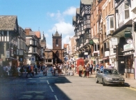
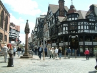
Chester (Welsh: Caer) is a very pretty and historic English city on the river Dee in the North-Western county of Cheshire. Although maybe not worth a whole holiday, it's well worth a day trip to see the Roman ruins. This fine city is also the gateway to North Wales, standing as it does directly on the border with the Principality. It is the nearest city of any size for a sizeble population in North Wales.
Understand
Chester originated in the Romano-British period at the latest, when it formed the settlement known as Deva or Castra Devana, the fortress city of the 20th Legion (Legio XX Valeria Victrix). As a result some parts of Chester are around two thousand years old. It was a Royalist stronghold during the English Civil War in the 1640s, and along the walls one can see the tower from which King Charles I watched his troops do battle.
A native of Chester is called a 'Cestrian'. Just as Cockneys must be born within earshot of the Bow Bells to be classed a 'true' Cockney, local tradition dictates that to be strictly deemed a 'Cestrian' the person must have been born within the boundaries of the city's Roman walls. However, the last maternity ward within those defined limits was relocated to its current site a couple of miles outside the city walls in the early 1970s.
See
- ⊙Cathedral, 12 Abbey Square, ☎ +44 1244 324756. 9AM-5PM. Free, but a donation of £3 is suggested per adult.
- ⊙Grosvenor Park. The main ornamental park in Chester and includes a pond, miniature railway, open air theatre and children's play area.
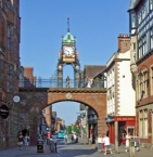
- ⊙The Eastgate Clock. It is claimed to be the second most photographed clock in the UK. Gatehouse from 1768-9 and clock dating from 1899.
(updated Sep 2016)
Roman Chester
Chester (or "Deva" in Latin) was one of the great military bases in Roman England, and as such, has its fair share of Roman ruins. Historians have even speculated that had the Roman departure not happened, Chester would have become the Roman Capital of England.
- Walls. The city centre is enclosed by the walls, which offer a pleasant strolling route for visitors and locals alike. Walk around the top of Roman walls that surround the city.
- ⊙Amphitheatre, Vicars Lane, Chester (Adjacent to the Grosvenor Park). Believed to have been the site of the largest wooden structure amphitheatre in the Roman Empire outside of Rome for its time, with a larger stone amphitheatre later built on-top of the foundations
- Roman Gardens. With reconstructed hypocaust.
- Spud u Like, Bridge Street. The basement of this shop gives access to an original hypocaust.
Informationen zu Urheber-Rechten | |
|---|---|
Rechte-Ausprägung / Lizenz | by-sa: CREATIVE COMMONS Namensnennung, Weitergabe unter gleichen Bedingungen |
Link zur Rechtebeschreibung | |
Text(e) übernommen von: |
Wikivoyage contributors, 'Chester', Wikivoyage, The FREE worldwide travel guide that anyone can edit, 16 December 2019, 13:22 UTC, https://en.wikivoyage.org/w/index.php?title=Chester&oldid=3897289 [accessed 26 December 2019] |
übernommen / bearbeitet am | 26.12.2019
|
übernommen / bearbeitet durch |
|
2 km
0,7 km
34 m
3 km
0,7 km
19 m
3 km
0,9 km
26 m
![]()


