
Aida-Radweg (Alta Italia da Attraversare)
Nr. des Radweges BI20
Aktionen
![]()
Bitte warten - Kartendaten werden geladen
Erstellt am 21.07.2020,
zuletzt geändert von biroto-Redaktion am 20.10.2023
Aktionen
Strecken-Merkmale
Gesamtlänge in km
934
Informationen zu Rechten an den GPS-Track-Daten | |
|---|---|
Rechte-Inhaber | OpenStreetMap and Contributors + biroto-Redaktion (biroto.eu) |
Rechte-Ausprägung / Lizenz | Enthält Daten von OpenStreetMap, die hier unter der Open Database License(ODbL) verfügbar gemacht werden |
Link zur Rechtebeschreibung | |
gpx-Datei übernommen aus | |
gpx-Datei hochgeladen | durch biroto-Redaktion am 20.10.2023
|
Gesamtzahl Trackpoints
16.086
Trackpoint-Dichte per km
17
Endorte
Start
Moncenisio, 21, IT (1703 m NHN)
Ziel
Trieste, 36, IT (0 m NHN)
Fahrradfreundliche Unterkünfte, Sehenswertes und Infrastruktur
Name u. Anschrift
Breite / Länge
Tel.
Fax.
Mobile
Art d. Unterkunft
Radler-freund-lichkeit
Strecken-km
km zur Strecke
Höhe
26 km
0,8 km
496 m
Informationen zu Urheber-Rechten | |
|---|---|
Rechte-Inhaber | |
Rechte-Ausprägung / Lizenz | cc0: Public Domain keine Rechte vorbehalten |
Link zur Rechtebeschreibung | |
Bild übernommen aus | |
Bild hochgeladen | durch biroto-Redaktion am 04.12.2014
|
Informationen zu Urheber-Rechten | |
|---|---|
Rechte-Inhaber | |
Rechte-Ausprägung / Lizenz | by-sa: CREATIVE COMMONS Namensnennung, Weitergabe unter gleichen Bedingungen |
Link zur Rechtebeschreibung | |
Bild übernommen aus | |
Bild hochgeladen | durch biroto-Redaktion am 04.12.2014
|
Informationen zu Urheber-Rechten | |
|---|---|
Rechte-Inhaber | |
Rechte-Ausprägung / Lizenz | by-sa: CREATIVE COMMONS Namensnennung, Weitergabe unter gleichen Bedingungen |
Link zur Rechtebeschreibung | |
Bild übernommen aus | |
Bild hochgeladen | durch biroto-Redaktion am 04.12.2014
|
Informationen zu Urheber-Rechten | |
|---|---|
Rechte-Inhaber | |
Rechte-Ausprägung / Lizenz | by-sa: CREATIVE COMMONS Namensnennung, Weitergabe unter gleichen Bedingungen |
Link zur Rechtebeschreibung | |
Bild übernommen aus | |
Bild hochgeladen | durch biroto-Redaktion am 04.12.2014
|
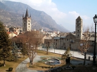
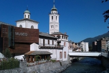
Susa (französisch Suse) ist eine Kleinstadt mit 6549 Einwohnern (Stand 2013) in der italienischen Provinz Turin, Region Piemont am Fuße des Mont-Cenis-Passes ![]() .
.
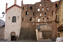
Sehenswürdigkeiten
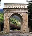
- Augustusbogen (8 v. Chr.)
- Überreste von Amphitheater, Aquädukt und die Stadtbefestigung (3. Jahrhundert)
- Porta Savoia
- Castello della marchesa Adelaide (11. Jahrhundert)
- Kathedrale San Guisto (11. Jahrhundert)
- Museo Diocesano di Arte Sacra
Informationen zu Urheber-Rechten | |
|---|---|
Rechte-Ausprägung / Lizenz | by-sa: CREATIVE COMMONS Namensnennung, Weitergabe unter gleichen Bedingungen |
Link zur Rechtebeschreibung | |
Text(e) übernommen von: |
Seite „Susa (Piemont)“. In: Wikipedia, Die freie Enzyklopädie. Bearbeitungsstand: 1. November 2014, 23:50 UTC. URL: http://de.wikipedia.org/w/index.php?title=Susa_(Piemont)&oldid=135437983 (Abgerufen: 3. Dezember 2014, 17:36 UTC) |
übernommen / bearbeitet am | 03.12.2014 - 04.12.2014
|
übernommen / bearbeitet durch |
|
26 km
0,5 km
494 m
Öffnungszeiten
Monday-Saturday: 09.00-12.00 ; 15.00-18.00
Sunday: 09.00-13.00
53 km
0,7 km
887 m
Informationen zu Urheber-Rechten | |
|---|---|
Rechte-Inhaber | |
Rechte-Ausprägung / Lizenz | by-sa: CREATIVE COMMONS Namensnennung, Weitergabe unter gleichen Bedingungen |
Link zur Rechtebeschreibung | |
Bild übernommen aus | |
Bild hochgeladen | durch biroto-Redaktion am 03.12.2014
|
Informationen zu Urheber-Rechten | |
|---|---|
Rechte-Inhaber | |
Rechte-Ausprägung / Lizenz | cc0: Public Domain keine Rechte vorbehalten |
Link zur Rechtebeschreibung | |
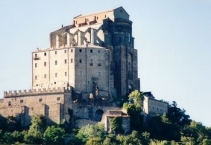
Bild übernommen aus | commons.wikimedia.org/wiki/File:Sacra_di_San_Michele_-_Corpo_centrale.jpg |
Bild hochgeladen | durch biroto-Redaktion am 03.12.2014
|
Informationen zu Urheber-Rechten | |
|---|---|
Rechte-Inhaber | |
Rechte-Ausprägung / Lizenz | by-sa: CREATIVE COMMONS Namensnennung, Weitergabe unter gleichen Bedingungen |
Link zur Rechtebeschreibung | |
Bild übernommen aus | commons.wikimedia.org/wiki/File:Sacra_di_san_michele,_chiesa_abbaziale,_portale_03.JPG |
Bild hochgeladen | durch biroto-Redaktion am 03.12.2014
|
Informationen zu Urheber-Rechten | |
|---|---|
Rechte-Inhaber | |
Rechte-Ausprägung / Lizenz | by-sa: CREATIVE COMMONS Namensnennung, Weitergabe unter gleichen Bedingungen |
Link zur Rechtebeschreibung | |
Bild übernommen aus | |
Bild hochgeladen | durch biroto-Redaktion am 03.12.2014
|
The Sacra di San Michele, sometimes known as Saint Michael's Abbey, is a religious complex on Mount Pirchiriano, situated on the south side of the Val di Susa ![]() overlooking the villages of Avigliana
overlooking the villages of Avigliana ![]() and Chiusa di San Michele
and Chiusa di San Michele ![]() , northern Italy. The abbey, which for much of its history came under Benedictine rule, is now entrusted to the Rosminians. A special regional law acknowledges it as the "Symbolic monument of the Piedmont region". The book The Name of the Rose was inspired by this monumental abbey.
, northern Italy. The abbey, which for much of its history came under Benedictine rule, is now entrusted to the Rosminians. A special regional law acknowledges it as the "Symbolic monument of the Piedmont region". The book The Name of the Rose was inspired by this monumental abbey.
Little is known of the early years of the abbey. The oldest extant account is that of a monk, William, who lived here in the late 11th century and wrote a Chronicon Coenobii Sancti Michaelis de Clusa. He sets the foundation of the abbey in 966, but, in another passage, the same monk maintains that the construction began under the pontificate of Sylvester II (999-1003).
What is certain is that what is now the crypt was built in the late 10th century, as attested by the Byzantine influence in the niches, columns and arches. According to tradition, this building was constructed by the hermit Saint Giovanni Vincenzo at the behest of the archangel Michael to whom he was particularly devoted; and the building materials which the hermit had collected were transported miraculously to the top of the mountain.
In the following years a small edifice was added, which could house a small community of monks and some pilgrims.
Later the abbey developed under the Benedictine rule, with the construction of a separate building with guest-rooms for pilgrims following the popular Via Francigena ![]() and of a church-monastery (1015–1035), probably on the remains of the ancient Roman castrum.
and of a church-monastery (1015–1035), probably on the remains of the ancient Roman castrum.
Abbot Ermengardo (1099–1131) had a new large, 26 m-high basement built from the foot of the hill to its peak, on which a new church (the one still existing today) was added, including the surrounding structures.
The monastery fell into decline and was finally suppressed in 1622 by Pope Gregory XV. It remained abandoned until 1835, when King Charles Albert and the Pope asked Antonio Rosmini to restore and repopulate it. It is currently under the care Rosminians.
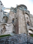
Art and architecture
The church, whose construction lasted for many years, is characterized by the unusual position of the façade, which is at a lower level than the floor of the church's interior.
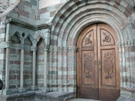
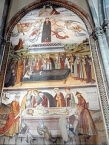
The 41 m-high façade gives access to the Scalone del Morti ("Stairway of the Dead"), flanked by arches, niches and tombs in which, until recent times, skeletons of dead monks where visible (hence the name). At the top of the steps is the marble Porta dello Zodiaco, a masterwork of 12th century sculpture. The church itself is accessed by a Romanesque portal in grey and green stone, built in the early 11th century. The church has a nave and two aisles, and features elements from both the Gothic and Romanesque styles of architecture. On the left wall is a large fresco portraying the Annunciation (1505), while in the Old Choir is a triptych by Defendente Ferrari.
The complex includes the ruins of the 12th-15th centuries monastery, which had five floors. It ends with the Torre della Bell'Alda ("Tower of the Beautiful Alda") The so-called "Monks' Sepulchre" is probably the remains of a chapel reproducing, in its octagonal plan, the Holy Sepulchre of Jerusalem.
Informationen zu Urheber-Rechten | |
|---|---|
Rechte-Ausprägung / Lizenz | by-sa: CREATIVE COMMONS Namensnennung, Weitergabe unter gleichen Bedingungen |
Link zur Rechtebeschreibung | |
Text(e) übernommen von: |
Wikipedia contributors, 'Sacra di San Michele', Wikipedia, The Free Encyclopedia, 31 March 2014, 18:05 UTC, <http://en.wikipedia.org/w/index.php?title=Sacra_di_San_Michele&oldid=602143287> [accessed 3 December 2014] |
übernommen / bearbeitet am | 03.12.2014
|
übernommen / bearbeitet durch |
|
Öffnungszeiten
Winter timetable from October 16 to March 15
- Weekdays: 9.30-12.30, 14.30-17.00;
- Sundays and public holidays: 9.30-12.00, 14.30-17.30;
Summer timetable from March 16 to October 15
- Weekdays: 9.30-12.30, 14.30-18.00;
- Sundays and public olidays: 9.30-12.00, 14.30-18.30;
The last entry is allowed 30 minutes before closing
Closing day:
Monday, except public holidays
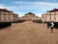
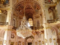
91 km
0,5 km
236 m
Informationen zu Urheber-Rechten | |
|---|---|
Rechte-Inhaber | |
Rechte-Ausprägung / Lizenz | by-sa: CREATIVE COMMONS Namensnennung, Weitergabe unter gleichen Bedingungen |
Link zur Rechtebeschreibung | |
Bild übernommen aus | en.wikipedia.org/wiki/File:Palazzina_di_caccia_di_Stupinigi1.JPG |
Bild hochgeladen | durch biroto-Redaktion am 03.12.2014
|
Informationen zu Urheber-Rechten | |
|---|---|
Rechte-Inhaber | |
Rechte-Ausprägung / Lizenz | by-sa: CREATIVE COMMONS Namensnennung, Weitergabe unter gleichen Bedingungen |
Link zur Rechtebeschreibung | |
Bild übernommen aus | commons.wikimedia.org/wiki/File:Stupinigi_centrale_hal_boven.jpg |
Bild hochgeladen | durch biroto-Redaktion am 03.12.2014
|
Das Schloss von Stupinigi (ital. palazzina di caccia di Stupinigi, dt. Jagdschlösschen von Stupinigi), ca. 10 Kilometer südwestlich von Turin ![]() in der Gemeinde Nichelino
in der Gemeinde Nichelino ![]() , war ein Jagdsitz der Herzöge von Savoyen. Es steht auf der Liste des UNESCO-Welterbes.
, war ein Jagdsitz der Herzöge von Savoyen. Es steht auf der Liste des UNESCO-Welterbes.
Herzog Viktor Amadeus II. wünschte sich in der Nähe der Residenzstadt Turin ein zeitgemäßes Jagdhaus und beauftragte seinen Hofarchitekten Filippo Juvarra mit dem Bau eines Schlosses. Juvarra hatte bisher eine glänzende Karriere im Dienst der Savoyer beschrieben und legte 1729 die Pläne für sein letztes großes Werk in Italien vor.
Der Bau Juvarras und Kern des künftigen Barockschlosses bestand aus einem großen, mehreckigen und kuppelüberwölbten Festsaal, der mit vier Flügelbauten in der Form eines Andreaskreuzes gerahmt war. Diese vier Flügel nahmen weitere Festsäle und die Privaträume des Herrscherpaares auf, der Bau war bis 1734 weitgehend beendet. Bereits wenige Jahre später erschien dem neuen Herzog Karl Emanuel III. dieses „Palazzina“ genannte Schlösschen zu klein und er beauftragte die Architektenfamilie Bernard mit der Erweiterung des Baus.
An das zentrale Corps de Logis wurde nun eine Reihe von Seitenflügeln angefügt, die gemeinsam eine Abfolge von Ehrenhöfen bilden. Bemerkenswert ist, dass der gesamte Grundriss kaum rechte Winkel bietet und das Schloss somit bis ins Detail einem gigantischen Ornament gleicht, zusammen mit den heiteren Dekorationen der Fassaden deutet der Bau damit schon das nahende Rokoko und die Abkehr von den strengen barocken Formen an.
Das zentrale Motiv der Innenausstattung ist die Jagd, die hier in zahlreichen Gemälden dargestellt ist. Die Kuppel des Schlosses, auf die eine mächtige Allee zuführt und das spätestens durch den Anbau der Seitenflügel vom Schlösschen zum Schloss gewachsen ist, wird von einem kupfernen Hirschen bekrönt und deutet damit schon von weitem den Zweck des Gebäudes an.
Das Schloss ist heute als Museum für Besucher zugänglich.
Informationen zu Urheber-Rechten | |
|---|---|
Rechte-Ausprägung / Lizenz | by-sa: CREATIVE COMMONS Namensnennung, Weitergabe unter gleichen Bedingungen |
Link zur Rechtebeschreibung | |
Text(e) übernommen von: |
Seite „Schloss Stupinigi“. In: Wikipedia, Die freie Enzyklopädie. Bearbeitungsstand: 31. Oktober 2014, 21:44 UTC. URL: http://de.wikipedia.org/w/index.php?title=Schloss_Stupinigi&oldid=135404916 (Abgerufen: 3. Dezember 2014, 16:16 UTC) |
übernommen / bearbeitet am | 03.12.2014
|
übernommen / bearbeitet durch |
|
100 km
1,3 km
235 m
![]()