Drucken der Seiteninhalte ist nur für registrierte und angemeldete Nutzer in Form des Tourenbuches möglich!

Radweg Limbaži-Saulkrasti-Birini-Limbaži

Nr. des Radweges LV 109

busy


Bitte warten - Kartendaten werden geladen

0100200
Höhen-Profil Radweg Limbaži-Saulkrasti-Birini-LimbažiLimbažiIgate pils0100200020406080100120

Erstellt am 29.08.2014,

am 29.08.2014

Strecken-Merkmale

Gesamtlänge in km

92

GPS-Track-Daten

Informationen zu Rechten an den GPS-Track-Daten

Rechte-Inhaber

Ottocolor

Rechte-Ausprägung / Lizenz

by-sa: CREATIVE COMMONS Namensnennung, Weitergabe unter gleichen Bedingungen

Link zur Rechtebeschreibung

creativecommons.org/licenses/by-sa/3.0/de/

gpx-Datei hochgeladen

durch Ottocolor am 29.08.2014

Gesamtzahl Trackpoints

673

Trackpoint-Dichte per km

7

Endorte

Start

Lemsal, Livland, LV (73 m NHN)

Ziel

Lemsal, Livland, LV (75 m NHN)

Charakter

Latvian regional route no. 109 is a round trip in western Livonia (latvian Vidzeme) beginning and ending in the medium sized town of Limbaži. It goes south to the coastline at Saulkrasti, and from there into the countryside and then north back to Limbaži.

Informationen zu Urheber-Rechten

Rechte-Ausprägung / Lizenz

by-sa: CREATIVE COMMONS Namensnennung, Weitergabe unter gleichen Bedingungen

Link zur Rechtebeschreibung

creativecommons.org/licenses/by-sa/3.0/de/

übernommen / bearbeitet am

29.08.2014

übernommen / bearbeitet durch

Ottocolor

Fahrradfreundliche Unterkünfte, Sehenswertes und Infrastruktur

Name u. Anschrift

Breite / Länge

Tel.
Fax.
Mobile

Art d. Unterkunft

Strecken-km
km zur Strecke
Höhe über NHN

Radlerfreundlichkeit


0 km
0,1 km
69 m

LV-4001 Limbaži


Historisches Ortsbild

Gemeinde Limbazi
Gemeinde Limbazi
Burgruine von Limbaži
Lutherische Kirche in Limbaži
Denkmal von Karlis Baumanis

Limbaži (( Estonian: Lemsalu, German: Lemsal, Livonian: Lämmist nīn) is a town in the Vidzeme Wikipedia Icon region of northern Latvia. Limbaži is located 90 km northeast of the capital Riga Wikipedia Icon. The population is 8705 people. During the Middle Ages, as part of Livonia, Limbazi was a fortified town with stone walls, second in importance only to Riga.

Etymology

The name Lämmist nīn is believed to be a Livonian word meaning "wide isle in a forest swamp". The German Lemsahl is derived from the Livonian name.

According to folk etymology, the name Limbaži originated sometime in the 17th century. A recently arrived Swedish minister overheard some gibberish, "limba" and "aži". Mistakenly, he assumed this was the name of the village, and so the town was called "Limbaži".

History

In ancient times, Limbaži was a Livonian settlement known as Lemisele, part of Metsepole Wikipedia Icon. In the early 13th century, Bishop Albert and the Teutonic knights destroyed the village while conquering Metsepole, and built a castle, around which formed the new city, Lemsahl.

Medieval Limbaži

Until the beginning of the 16th century, Lemsahl could be reached by seagoing vessels travelling up the Svētupe. Ships came from as far as Lübeck and Copenhagen to trade for honey, wax, lumber, grain, and furs. The small trading camp surrounding the castle grew into a large town, and was admitted to the Hanseatic League. Each year, Lemsahl hosted a conference attended by barons from all over Livonia, and the city hosted at least three other fairs throughout the year as well. During these fairs, the town may have held as many as 20,000 people at once. In addition, the Bishop of Riga made Lemsahl his spring residence, which became a walled city to protect both the bishop and the trading center. In population, Lemsahl was second only to Riga.

By 1500, however, the Svētupe became too shallow to navigate. Goods were sent elsewhere, and Lemsahl began a century long decline. During the Livonian War, Ivan the Terrible's forces burned down Lemsahl in 1558, while its residents fled to the nearby forests and marshes for shelter. The city was burned down by the Swedes in 1567, and again by the Russians in 1575. In 1602, the Swedes and Poles fought yet again for the city, completely demolishing its fortifications and walls. By the time the wars had ended, the city was so demolished, only three houses and a handful of residents remained.

18th and 19th centuries

While under Swedish rule, the village was renamed Limbaži sometime in the 17th century. During the Great Northern War, Vidzeme was totally ravaged by Peter the Great's forces. But as the story goes, while searching for Limbaži, the Russian army got lost in a heavy fog. After stumbling in circles, the soldiers began to believe such a village may not exist after all, and moved on. Limbaži survived the war unscathed.

The city completely burned down again in 1747, after which today's city layout began to develop. In the 19th century, the city began to grow again. In 1821 there were 674 inhabitants, but by 1900 there were about 2000. In 1876, hat-maker A.Tīls opened "Limbažu Filcs", the town's oldest company, which also secured jobs for generations of the city's inhabitants. The first town library was built in the late 19th century, and several publishing houses were opened, the largest of which was K.Paucīsis Press.

Twentieth century

After World War I Limbaži continued to grow. The long-awaited rail line to Riga opened in 1934, and a 50-bed hospital opened in 1936. During the Soviet occupation the population increased to 8,000, with many five-storey Soviet-style apartments appearing in the 1960s. During the Soviet period, Limbaži became a factory-town with "Lauktehnika" farm machinery, "Limbažu Filcs" hats, and "Limbažu Piens" one of the largest milk processors in Latvia, all based there.

Informationen zu Urheber-Rechten

Rechte-Ausprägung / Lizenz

by-sa: CREATIVE COMMONS Namensnennung, Weitergabe unter gleichen Bedingungen

Link zur Rechtebeschreibung

creativecommons.org/licenses/by-sa/3.0/de/

Text(e) übernommen von:

Limbaži.(2016, November 17). In Wikipedia, The Free Encyclopedia. Retrieved 06:51, February 9, 2017, from https://en.wikipedia.org/w/index.php?title=Limba%C5%BEi&oldid=749970492

übernommen / bearbeitet am

09.02.2017

übernommen / bearbeitet durch

Ottocolor


31 km
0,2 km
14 m


LV-Skulte Skulte


Pension/Gästehaus


41 km
0,1 km
21 m


LV-LV-2160 Saulkrasti


Camping


59 km
0,8 km
47 m


LV-4013 Bīriņi


Hotel


76 km
0,0 km
49 m

LV-4013 Vidriži


Gutshaus/Herrenhaus

Herrenhaus Igate
Herrenhaus Igate
Herrenhaus Igate
Herrenhaus Igate

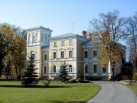
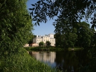
Das Schloss Igate befindet sich in Igate, Gemeinde Vidriži, Bezirk Limbaži. Es wird erstmals 1455 in Schriften erwähnt, als Idsel Diderik Fitinghof das Dorf und das Herrenhaus an Peter von der Borham verkaufte. Der Name des Herrenhauses hat sich mehrmals geändert.

Um 1880 wurde in Igate ein Herrenhaus im Neorenaissance-Stil errichtet. Das Gebäude wurde von Rudolf Heinrich Zircwitz von Pistolkors entworfen und demonstriert zurückhaltenden und raffinierten Lakonismus. 1934 wurde das Herrenhaus von der Lettischen Kinderunion gekauft und es gab ein Kinderinternat im Schloss. Im Sommer 1940 wurde es in ein Waisenhaus umgewandelt. Ab 1972 stand Igate Castle unter der Kontrolle des Landwirtschaftsministeriums. 1996 wurde Igate Castle von der State Real Estate Agency übernommen.

Informationen zu Urheber-Rechten

Rechte-Ausprägung / Lizenz

by-sa: CREATIVE COMMONS Namensnennung, Weitergabe unter gleichen Bedingungen

Link zur Rechtebeschreibung

creativecommons.org/licenses/by-sa/3.0/de/

Text(e) übernommen von:

Vikipēdijas dalībnieki, 'Igates pils', Vikipēdija, Brīvā enciklopēdija, 10 jūnijs 2020, 02.56 UTC, [iegūts 15 februāris 2021]

übernommen / bearbeitet am

20.09.2011 - 15.02.2021

übernommen / bearbeitet durch

biroto-Redaktion


busy


Close

Code Schnipsel zum Verlinken von Radweg Limbaži-Saulkras ...

Falls Sie von Ihrer Webseite auf diesen Radweg/diese Tour verlinken möchten, kopieren Sie einfach folgenden Codeschnippsel und stellen ihn an einer geeigneten Stelle in Ihrem Quellcode ein:

Close

Radweg Limbaži-Saulkrasti-Birini-Limbaži übernehmen

Nach Ausführung dieser Funktion ist Ihnen das Bearbeiten der GPS-Track-Daten und der Beschreibung zur ausgewählten Route möglich.

Diese Bearbeitung wird am Original, nicht an einer Kopie vorgenommen.

Sie werden dabei zum Eigentümer der Route!