
Cycle Route West Coast Cycleroute Sweden
Actions
![]()
Please wait - map data are loading
Added on 14 Dec 2011,
last edited by biroto-Redaktion on 09 Dec 2020
Actions
Cycle route metrics
Total distance in km
679
Information about rights to the gps-track data | |
|---|---|
Rights owner | biroto-Redaktion & biroto-Contributors |
Rights characteristic / license | by-sa: CREATIVE COMMONS Attribution-ShareAlike |
Link to the description of the license | |
GPX file taken from | |
GPX file uploaded | by biroto-Redaktion on 09 Dec 2020
|
Track points in total
11.508
Track points per km (avg)
17
Start/endpoint
Start location
Svinesund, Västra Götalands län, SE (66 m NHN)
End location
Höllviken, Skåne, SE (1 m NHN)
Remarks
The west coast route no longer exists as a independent cycle route. The course of the previous route is the same as that of today's cycle routes EV12 and EV7.
Beds4Cyclists, worth visiting and infrastructure
Name and address
Latitude / Longitude
Phone
Fax
Mobile
Type of accommodation
Rating for cyclists
Route km
Dist. to route
Elevation
73 km
0,1 km
20 m
Information about copyright | |
|---|---|
Rights owner | |
Rights characteristic / license | by-sa: CREATIVE COMMONS Attribution-ShareAlike |
Link to the description of the license | |
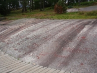
Image taken over from | https://commons.wikimedia.org/wiki/File:Tanumshede_2005_rock_carvings_2.jpg |
Image has been uploaded | by biroto-Redaktion on 29 Dec 2018
|
Information about copyright | |
|---|---|
Rights owner | |
Rights characteristic / license | by-sa: CREATIVE COMMONS Attribution-ShareAlike |
Link to the description of the license | |
Image taken over from | https://commons.wikimedia.org/wiki/File:Tanumshede_2005_rock_carvings_4.jpg |
Image has been uploaded | by biroto-Redaktion on 29 Dec 2018
|
Information about copyright | |
|---|---|
Rights owner | |
Rights characteristic / license | cc0: Public Domain no Rights reserved |
Link to the description of the license | |
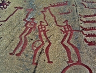
Image taken over from | https://commons.wikimedia.org/wiki/File:Tanumshede_2005_rock_carvings_5.jpg |
Image has been uploaded | by biroto-Redaktion on 29 Dec 2018
|
The Rock Carvings in Tanum (Swedish: Hällristningsområdet i Tanum) are a collection of petroglyphs near Tanumshede ![]() , Bohuslän, Sweden, which were declared a World Heritage Site by UNESCO in 1994 because of their high concentration
, Bohuslän, Sweden, which were declared a World Heritage Site by UNESCO in 1994 because of their high concentration
In total there are thousands of images called the Tanum petroglyphs, on about 600 panels within the World Heritage Area. These are concentrated in distinct areas along a 25 km stretch, and covers an area of about 51 hectares (126 acres or 0.5 km²).
While the region was on the coastline when the drawings were made, it is now at an elevation of 25m.
Scandinavian Bronze Age and Iron Age people were sophisticated craftsmen and very competent travelers by water. (Dates for ages vary with the region; in Scandinavia, the Bronze Age is roughly 1800 to 500 BCE) Many of the glyphs depict boats of which some seem to be of the Hjortspring boat type carrying around a dozen passengers. Wagons or carts are also depicted.
Other glyphs depict humans with a bow, spear or axe, and others depict hunting scenes. In all cases the pictures show people performing rituals. There is a human at a plough drawn by two oxen, holding what might be a branch or an ox-goading crop made of a number of strips of hide.
One of the larger rocks of Nordic Bronze Age petroglyphs in Scandinavia (at 22 metres tall and 6 metres wide), the Vitlyckehäll, is located in Tanumshede. It contains nearly 300 carvings of a variety of scenes, people, and objects.
The rock carvings are endangered by erosion due to acid rain and some are thus covered either permanently or during certain times of the year. Some have been painted red to make them more visible for tourists; a practice which has drawn criticism for removing the authenticity and original state of the drawings.
The site was named a World Heritage Site by UNESCO in 1994; encompassing approximately 45 km² in total. It is visited by approximately 100,000 people per year, though visitors are not permitted to walk on or touch the drawings.
Vitlycke museum (UNESCO information centre). From Easter to the beginning of November, weekends in April and daily May to November, times depending on the season. Located near the Vitlycke carvings, the small museum contains an audiovisual exposition of the life in Tanum 3000 years ago. The outdoor area includes a reconstruction of a bronze age farm, the way archeologicsts imagine it. A large part of the information center consists of a souvenir shop and a caffeteria with local and organic food and a great view over the Vitlycke site. The information center offers guided tours. Free.
Information about copyright | |
|---|---|
Rights characteristic / license | by-sa: CREATIVE COMMONS Attribution-ShareAlike |
Link to the description of the license | |
Input taken over from: |
|
taken over / edited on | 29 Dec 2018
|
taken over / edited by |
|
Hours of opening
Vitlycke museum
18 - 22 April 10.00-16.00
27 April - 31 August 10.00-18.00
1 september - 3 November 10-16
74 km
4,5 km
1 m
273 km
0,1 km
7 m
278 km
1,3 km
34 m
280 km
0,6 km
12 m
![]()