
Abdij van Keizersberg
Sehenswürdigkeiten
Erstellt am 17.10.2017,
zuletzt geändert von biroto-Redaktion am 17.10.2017
Radwege und Fahrrad-Touren in der Nähe
| Name/Bezeichnung | Typ | km zur Strecke |
|---|---|---|
Route | 0,3 km | |
Route | 0,7 km | |
Route | 1,1 km | |
Route | 1,1 km | |
Route | 1,1 km | |
Route | 3,2 km | |
Route | 3,2 km | |
Tour | 0,3 km | |
Tour | 0,7 km | |
Tour | 0,7 km | |
Tour | 0,7 km | |
Tour | 0,7 km | |
Tour | 0,7 km |
![]()
Bitte warten - Kartendaten werden geladen
Art der Sehenswürdigkeit
(ehem.) Kloster
Name u. Anschrift
Abdij van Keizersberg
∎∎∎∎∎∎∎∎∎∎∎∎∎∎ ∎∎∎
BE-3000 Leuven
GEO-Daten
GEO-Koordinaten
50.88∎∎∎∎ 4.69∎∎∎∎
Höhe
50 m
Kommunikation
Internet
∎∎∎.∎∎∎∎∎∎∎∎∎∎∎.∎∎/
Informationen zu Urheber-Rechten | |
|---|---|
Rechte-Inhaber | |
Rechte-Ausprägung / Lizenz | by-sa: CREATIVE COMMONS Namensnennung, Weitergabe unter gleichen Bedingungen |
Link zur Rechtebeschreibung | |
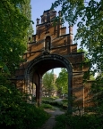
Bild übernommen aus | https://commons.wikimedia.org/wiki/File:42148_neogotische_poort_keizersberg_leuven.jpg |
Bild hochgeladen | durch biroto-Redaktion am 17.10.2017
|
Informationen zu Urheber-Rechten | |
|---|---|
Rechte-Inhaber | |
Rechte-Ausprägung / Lizenz | by-sa: CREATIVE COMMONS Namensnennung, Weitergabe unter gleichen Bedingungen |
Link zur Rechtebeschreibung | |
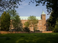
Bild übernommen aus | https://commons.wikimedia.org/wiki/File:42148_Abdij_Keizersberg_overzicht.jpg |
Bild hochgeladen | durch biroto-Redaktion am 17.10.2017
|
Informationen zu Urheber-Rechten | |
|---|---|
Rechte-Inhaber | |
Rechte-Ausprägung / Lizenz | by-sa: CREATIVE COMMONS Namensnennung, Weitergabe unter gleichen Bedingungen |
Link zur Rechtebeschreibung | |
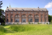
Bild übernommen aus | https://commons.wikimedia.org/wiki/File:Keizersberg_Abbey.JPG |
Bild hochgeladen | durch biroto-Redaktion am 17.10.2017
|
Keizersberg Abbey, also known as Mont César Abbey (Dutch: Abdij van Keizersberg; French: Abbaye du Mont-César) is a Benedictine monastery on the hill Keizersberg or Mont César in the north of the university town of Leuven ![]() , Belgium.
, Belgium.
The site
The Keizersberg ("Caesar's" or "Emperor's hill") was the site of the castle around which the city of Leuven grew up, and which local legend connected with Julius Caesar. The castle was demolished in 1782 by order of Emperor Joseph II. On the east side of the same hill a commandery of the Knights Templars was built in 1187, which when the order was abolished came to the Knights Hospitallers in 1312. This was secularised by the French in 1798, when the church and larger buildings were demolished.
In 1914 the buildings were severely damaged by fire, and the monks took refuge in another Beuronese house, Maria Laach Abbey in the Rhineland, until after the end of the war, when reconstruction was possible.
The abbey again suffered damage in World War II with the bombing of the buildings during air raids on Leuven in 1944, which among other things destroyed the last remains of the older buildings from the time of the Hospitallers, and the monastery was temporarily uninhabitable.
By 1948 it was sufficiently restored to be able to set up a small community at Wavreumont in Stavelot, which was formally established as St. Remaclus' Priory on 21 June 1952.
When the French section of the Catholic University of Leuven was moved out of Leuven it was decided that the abbey should become a Flemish institution, whence the change from Mont César to Keizersberg. On 10 June 1968 the abbey was transferred to the Flemish Province of the Subiaco Congregation. The abbot and prior resigned in the same year, and a temporary administrator was appointed.
In 1969 part of the renovated abbey was converted for use as student accommodation, and is still used for that purpose.
Informationen zu Urheber-Rechten | |
|---|---|
Rechte-Ausprägung / Lizenz | by-sa: CREATIVE COMMONS Namensnennung, Weitergabe unter gleichen Bedingungen |
Link zur Rechtebeschreibung | |
Text(e) übernommen von: |
Wikipedia contributors, 'Keizersberg Abbey', Wikipedia, The Free Encyclopedia, 21 November 2015, 13:18 UTC, <https://en.wikipedia.org/w/index.php?title=Keizersberg_Abbey&oldid=691674980> [accessed 17 October 2017] |
übernommen / bearbeitet am | 17.10.2017
|
übernommen / bearbeitet durch |
|
Radwege und Fahrrad-Touren in der Nähe
| Name/Bezeichnung | Typ | km zur Strecke |
|---|---|---|
Route | 0,3 km | |
Route | 0,7 km | |
Route | 1,1 km | |
Route | 1,1 km | |
Route | 1,1 km | |
Route | 3,2 km | |
Route | 3,2 km | |
Tour | 0,3 km | |
Tour | 0,7 km | |
Tour | 0,7 km | |
Tour | 0,7 km | |
Tour | 0,7 km | |
Tour | 0,7 km |
Erstellt am 17.10.2017,
zuletzt geändert von biroto-Redaktion am 17.10.2017