Ypres
Sehenswürdigkeiten
Erstellt am 18.10.2017,
zuletzt geändert von biroto-Redaktion am 12.04.2018
Radwege und Fahrrad-Touren in der Nähe
| Name/Bezeichnung | Typ | km zur Strecke |
|---|---|---|
Route | 0,0 km | |
Route | 0,0 km | |
Route | 0,1 km | |
Route | 4,8 km | |
Tour | 0,0 km | |
Tour | 0,1 km |
![]()
Bitte warten - Kartendaten werden geladen
Art der Sehenswürdigkeit
Historische(s) Gebäude
Name u. Anschrift
Ypres
BE-8900 Ypres
GEO-Daten
GEO-Koordinaten
50.85∎∎∎∎ 2.88∎∎∎∎
Höhe
32 m
Kommunikation
Informationen zu Urheber-Rechten | |
|---|---|
Rechte-Inhaber | Tony Grist |
Rechte-Ausprägung / Lizenz | cc0: Public Domain keine Rechte vorbehalten |
Link zur Rechtebeschreibung | |
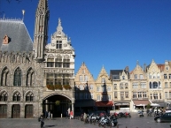
Bild übernommen aus | https://commons.wikimedia.org/wiki/File:Grote_Markt,_Ieper.jpg |
Bild hochgeladen | durch biroto-Redaktion am 18.10.2017
|
Informationen zu Urheber-Rechten | |
|---|---|
Rechte-Inhaber | Tony Grist |
Rechte-Ausprägung / Lizenz | cc0: Public Domain keine Rechte vorbehalten |
Link zur Rechtebeschreibung | |
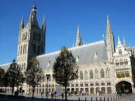
Bild übernommen aus | https://commons.wikimedia.org/wiki/File:Cloth_Hall,_Ieper_.jpg |
Bild hochgeladen | durch biroto-Redaktion am 18.10.2017
|
Informationen zu Urheber-Rechten | |
|---|---|
Rechte-Inhaber | |
Rechte-Ausprägung / Lizenz | by-sa: CREATIVE COMMONS Namensnennung, Weitergabe unter gleichen Bedingungen |
Link zur Rechtebeschreibung | |
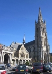
Bild übernommen aus | https://commons.wikimedia.org/wiki/File:Ypres_Sint-Maartenskathedraal.JPG |
Bild hochgeladen | durch biroto-Redaktion am 18.10.2017
|
Informationen zu Urheber-Rechten | |
|---|---|
Rechte-Inhaber | |
Rechte-Ausprägung / Lizenz | by-sa: CREATIVE COMMONS Namensnennung, Weitergabe unter gleichen Bedingungen |
Link zur Rechtebeschreibung | |
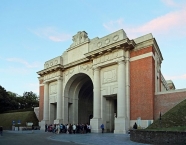
Bild übernommen aus | https://commons.wikimedia.org/wiki/File:Ieper_Menenpoort_R03.jpg |
Bild hochgeladen | durch biroto-Redaktion am 18.10.2017
|
Ypres (Dutch: Ieper, both pronounced "eeper") is a friendly town of 35,000 inhabitants in Flanders endowed with wonderful architecture and a troubled past. Ypres is best known as the site of three major battles of the First World War, the most famous being the Battle of Passchendaele from July - November 1917. The many memorials and cemeteries of the fallen in and around Ypres draw thousands of visitors each year. The belfry of Ypres is a ![]() UNESCO World Heritage site.
UNESCO World Heritage site.
Understand
The town of Ypres formed the centre of the so-called "Ypres Salient" during most of the First World War - an area of Allied (British and Belgian)-held land surrounded on three sides by the German front line that formed the northernmost section of the Western Front. Holding Ypres was vital for the Allies in their bid to prevent the Germans gaining control of all the Channel ports, vital for the transport and supply of the British Expeditionary Force. As a result, the city became the focus of several major battles to break in / out of the Salient and was subjected to fairly continuous bombardment by German artillery for most of the war. By 1918, little remained of the town but shattered ruins surrounded by muddy shell-pocked fields.
After the First World War, most of central Ypres was rebuilt with German reparations (war debt) money. This was a lengthy process: the famous Cloth Hall was not completed until the 1960s.
See
Landmarks and Memorials
- ⊙Menin Gate Memorial. Dedicated on 24 July 1927 as a memorial to the missing British and Commonwealth soldiers who fell in Belgium during World War One. Has a Last Post Ceremony each night at 8:00 PM as a way for the Ypres citizens to express their gratitude towards those who died for Belgium's freedom.
- This memorial contains, both inside and out, huge panels into which are carved the names of the 54,896 officers and men of the British Empire forces who died in the Ypres Salient area and who have no known graves. The names recorded on the gate's panels are those of men who died in the area between the outbreak of the war in 1914 and 15 August 1917. The names of a further 34,984 of the missing - those who died between 16th August, 1917 and the end of the war, are recorded on carved panels at Tyne Cot Cemetery, on the slopes just below Passchendaele.
- Cloth Hall - originally built around 1200 as a center of Flemish wealth, completely destroyed by German artillery shelling in 1916, the Cloth Hall was rebuilt, the project completing in 1962 and the symbol of a resurgent city. Contains the In Flanders Fields Museum.
- ⊙In Flanders Fields Museum. Apr-Sept 10AM-6PM, Oct-Mar T-Su 10AM—5PM, last entry 1 hr before closing. Located in the Ypres Cloth Hall, right in the center. This museum gives an excellent overview of WWI. It is more like an experience that takes you right into the daily life during the war. The experience is very moving, and it's a must-see for everyone coming to Ypres, young and old. Allow at least 2h for a full museum visit. When the weather is good enough, the belfry tower is also available for visit for additional cost, giving you a great overview over the front region. adults €9, youths 18-25 yrs €4, children 7-18 yrs €1, under 7 free.
- City fortification. Ypres has been a rather military city from its foundation on, being always on the boundary of some country. The oldest city walls, dating from 1385, were mostly destroyed for expansion. The city walls that are currently guarding the south and east of the city were created by the French architect Vauban in the 16th century. The walls are star-shaped, and made from thick dirt moats, allowing to hold back the heaviest artillery from that age to WWI onwards. Planted with trees, they form a green belt around the city centre.
- ⊙Casemates (Kazematten) (Just a bit south of the Menin gate, with entrances to the inner-city.). The Casemates were bomb-free shelters under the city fortifications. Also build by Vauban, and they even remained functional as armoury until WWI. Currently, they're brought back into use. One of them contains a pub, another one contains a brewery, and the rest is used for temporal expositions.
- ⊙Ramparts Cemetery, Rijselstraat. Military cemetery located within the town of Ypres with 198 Commonwealth burials next to the Lille Gate (Rijselpoort).
Eat
The marketplace has several restaurants, pubs and places to sit outside during the summer.
Tuesdays usually host music night outside, organised by "'t Klein Stadhuis" right next to the cloth halls and the city hall.
Informationen zu Urheber-Rechten | |
|---|---|
Rechte-Ausprägung / Lizenz | by-sa: CREATIVE COMMONS Namensnennung, Weitergabe unter gleichen Bedingungen |
Link zur Rechtebeschreibung | |
Text(e) übernommen von: |
Wikivoyage contributors, 'Ypres', Wikivoyage, The FREE worldwide travel guide that anyone can edit, 14 October 2017, 13:06 UTC, <https://en.wikivoyage.org/w/index.php?title=Ypres&oldid=3304833> [accessed 18 October 2017] |
übernommen / bearbeitet am | 18.10.2017 - 12.04.2018
|
übernommen / bearbeitet durch |
|
Radwege und Fahrrad-Touren in der Nähe
| Name/Bezeichnung | Typ | km zur Strecke |
|---|---|---|
Route | 0,0 km | |
Route | 0,0 km | |
Route | 0,1 km | |
Route | 4,8 km | |
Tour | 0,0 km | |
Tour | 0,1 km |
Erstellt am 18.10.2017,
zuletzt geändert von biroto-Redaktion am 12.04.2018


