
Carrick-a-Rede
Worth visiting
Added on 15 Jan 2019,
last edited by biroto-Redaktion on 04 Sep 2020
Nearby cycle routes and tours
| Route name | Type | Dist. to route |
|---|---|---|
Tour | 0,1 km |
![]()
Please wait - map data are loading
Type of sights
Bridge
Name and address
Carrick-a-Rede
GB-BT54 6LX Ballintoy
GEO-data
Geodetic coordinates
55.23∎∎∎∎ -6.33∎∎∎∎
Elevation
11 m
Communication
Information about copyright | |
|---|---|
Rights owner | |
Rights characteristic / license | by-sa: CREATIVE COMMONS Attribution-ShareAlike |
Link to the description of the license | |
Image taken over from | https://commons.wikimedia.org/wiki/File:Carrick-a-Rede_Bridge_-_geograph.org.uk_-_87464.jpg |
Image has been uploaded | by biroto-Redaktion on 15 Jan 2019
|
Information about copyright | |
|---|---|
Rights owner | https://commons.wikimedia.org/w/index.php?title=User:Hugo_van_dalen |
Rights characteristic / license | cc0: Public Domain no Rights reserved |
Link to the description of the license | |
Image taken over from | https://commons.wikimedia.org/wiki/File:Carrick_a_rede_2010.jpeg |
Image has been uploaded | by biroto-Redaktion on 15 Jan 2019
|
Information about copyright | |
|---|---|
Rights owner | |
Rights characteristic / license | by: CREATIVE COMMONS Attribution |
Link to the description of the license | |
Image taken over from | https://commons.wikimedia.org/wiki/File:Carrick-a-Rede_rope_bridge_20120623_143848.jpg |
Image has been uploaded | by biroto-Redaktion on 15 Jan 2019
|
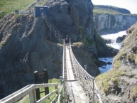
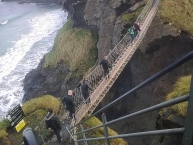
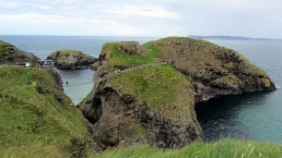
Carrick-a-Rede Rope Bridge (locally pronounced carrick-a-reedy) is a famous rope bridge near Ballintoy ![]() in County Antrim, Northern Ireland. The bridge links the mainland to the tiny island of Carrickarede (from Irish: Carraig a' Ráid, meaning "rock of the casting"). It spans 20 metres (66 ft) and is 30 metres (98 ft) above the rocks below. The bridge is mainly a tourist attraction and is owned and maintained by the National Trust. In 2009, it had 247,000 visitors. By 2016, that had increased to 440,000 visitors. The bridge is open all year round (subject to weather) and people may cross it for a fee.
in County Antrim, Northern Ireland. The bridge links the mainland to the tiny island of Carrickarede (from Irish: Carraig a' Ráid, meaning "rock of the casting"). It spans 20 metres (66 ft) and is 30 metres (98 ft) above the rocks below. The bridge is mainly a tourist attraction and is owned and maintained by the National Trust. In 2009, it had 247,000 visitors. By 2016, that had increased to 440,000 visitors. The bridge is open all year round (subject to weather) and people may cross it for a fee.
The area is exceptional in natural beauty with stunning views of Rathlin Island ![]() and Scotland. The site and surrounding area is designated an Area of Special Scientific Interest for its unique geology, flora, and fauna. Underneath there are large caves, which once served as home for boat builders and as shelter during stormy weathe
and Scotland. The site and surrounding area is designated an Area of Special Scientific Interest for its unique geology, flora, and fauna. Underneath there are large caves, which once served as home for boat builders and as shelter during stormy weathe
Information about copyright | |
|---|---|
Rights characteristic / license | by-sa: CREATIVE COMMONS Attribution-ShareAlike |
Link to the description of the license | |
Input taken over from: |
Wikipedia contributors, 'Carrick-a-Rede Rope Bridge', Wikipedia, The Free Encyclopedia, 26 December 2018, 20:19 UTC, https://en.wikipedia.org/w/index.php?title=Carrick-a-Rede_Rope_Bridge&oldid=875469658 [accessed 15 January 2019] |
taken over / edited on | 15 Jan 2019 - 04 Sep 2020
|
taken over / edited by |
|
Nearby cycle routes and tours
| Route name | Type | Dist. to route |
|---|---|---|
Tour | 0,1 km |
Added on 15 Jan 2019,
last edited by biroto-Redaktion on 04 Sep 2020