
Londonderry
Sehenswürdigkeiten
Erstellt am 15.01.2019,
zuletzt geändert von biroto-Redaktion am 16.01.2019
Radwege und Fahrrad-Touren in der Nähe
| Name/Bezeichnung | Typ | km zur Strecke |
|---|---|---|
Route | 0,1 km | |
EuroVelo: Atlantikküstenroute - Teil Schottland - Irland - Wales | Route | 0,1 km |
Route | 0,2 km | |
Tour | 0,1 km | |
Tour | 0,7 km |
![]()
Bitte warten - Kartendaten werden geladen
Art der Sehenswürdigkeit
Historische(s) Gebäude
Name u. Anschrift
Londonderry
GB-BT48 6XY Londonderry
GEO-Daten
GEO-Koordinaten
54.99∎∎∎∎ -7.31∎∎∎∎
Höhe
30 m
Kommunikation
Informationen zu Urheber-Rechten | |
|---|---|
Rechte-Inhaber | https://www.panoramio.com/user/7590076?with_photo_id=107925844 |
Rechte-Ausprägung / Lizenz | by-sa: CREATIVE COMMONS Namensnennung, Weitergabe unter gleichen Bedingungen |
Link zur Rechtebeschreibung | |
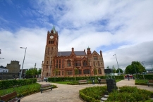
Bild übernommen aus | https://commons.wikimedia.org/wiki/File:Guild_Hall,_Derry_-_panoramio.jpg |
Bild hochgeladen | durch biroto-Redaktion am 16.01.2019
|
Informationen zu Urheber-Rechten | |
|---|---|
Rechte-Inhaber | |
Rechte-Ausprägung / Lizenz | by-sa: CREATIVE COMMONS Namensnennung, Weitergabe unter gleichen Bedingungen |
Link zur Rechtebeschreibung | |
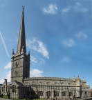
Bild übernommen aus | https://commons.wikimedia.org/wiki/File:Londonderry_St._Columb's_Cathedral_Nordirland@panorama.jpg |
Bild hochgeladen | durch biroto-Redaktion am 16.01.2019
|
Informationen zu Urheber-Rechten | |
|---|---|
Rechte-Inhaber | |
Rechte-Ausprägung / Lizenz | by-sa: CREATIVE COMMONS Namensnennung, Weitergabe unter gleichen Bedingungen |
Link zur Rechtebeschreibung | |
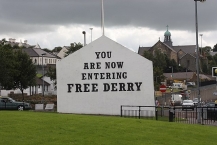
Bild übernommen aus | https://commons.wikimedia.org/wiki/File:Bogside_(15),_August_2009.JPG |
Bild hochgeladen | durch biroto-Redaktion am 16.01.2019
|
Informationen zu Urheber-Rechten | |
|---|---|
Rechte-Inhaber | |
Rechte-Ausprägung / Lizenz | by-sa: CREATIVE COMMONS Namensnennung, Weitergabe unter gleichen Bedingungen |
Link zur Rechtebeschreibung | |
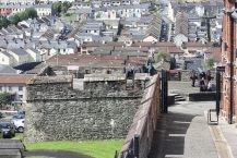
Bild übernommen aus | https://commons.wikimedia.org/wiki/File:Walls_of_Derry_(08),_August_2009.JPG |
Bild hochgeladen | durch biroto-Redaktion am 16.01.2019
|
Derry or Londonderry (Irish: 'Doire', meaning 'Oak Grove'), is the second city of Northern Ireland and the fourth largest city on the island of Ireland after Dublin, Belfast and Cork. It is situated on the river Foyle in County Londonderry, close to county Donegal in the Republic of Ireland. It has a population of roughly 100,000. Note that the name of the city is a point of political dispute, with unionists advocating the longer name, and nationalists advocating the shorter. A common attempt at compromise is to refer to the county as "Londonderry" and the city as "Derry", but this is by no means universally accepted. Because of this, a peculiar situation arises as there is no common consensus either in politics or elsewhere as to which name is preferred; the city council is officially known as "Derry", but the city is officially recognised as "Londonderry" by the Northern Ireland Executive and the UK government. Whilst road signs in the Republic of Ireland use "Derry", alongside the Irish language translation "Doire", road signs in Northern Ireland will always read (unless vandalised) "Londonderry".
Understand
Situated on the banks of River Foyle, Derry is the second largest city in Northern Ireland and one of the oldest inhabited places in the whole island of Ireland. As they say there, 'Derry was a city when Belfast was still a swamp'. Derry's history dates back over 1,450 years, a lasting reminder of the early inhabitants of the area is the Iron Age fort, just over the border in County Donegal, known as the Grianan of Aileach.
In the 6th Century St Columba/Colmcille established a monastery in Derry. Shifting ten centuries later to the Plantation of Ulster, King James I of England had the wealthy guilds of London build up the city of Derry (hence the title Londonderry) and surround it by the defensive walls that still ring the city today.
These walls witnessed one of the most prominent events in the history of Derry. In 1688 the city was laid siege by the Earl of Antrim and the Catholic forces of James II, the English king who was deposed in favour of Protestant William of Orange. The settlers of the city who were protestant, barricaded themselves within the walls, when a group of apprentice boys from London on seeing the oncoming forces, locked the city gates and so started the Great Siege of Derry.
The siege was to be the longest in British history, lasting some 105 days, during which an estimated third of the city’s then population of 30,000 died through disease and starvation. When James II himself rode up to the city walls and lay down terms for surrender he was greeted with shouts of ‘No Surrender’. The siege was finally broken when the relief ship Mountjoy broke the boom which was laid across the River Foyle beside the city.
However the legacy of the Great Siege of Derry lasted for centuries with the Catholic and Protestant communities in Derry still largely divided today. During the years of the Troubles, Derry witnessed some of the most prominent and terrible events of those times. It was on Derry's Bogside area that British soldiers shot dead 14 civil rights protesters in what became known as Bloody Sunday. The majority of the Bogside murals commemorate this tragic loss of innocents.
Since the peace process in Northern Ireland, Derry is slowly emerging as an upbeat cosmopolitan city with great potential and huge tourist interest. In July 2010, Derry was awarded City of Culture for 2013. A lot of Derry’s sights are meshed with its history, the 16th Century walls which surround the city are among the oldest and the best preserved citadel walls in Europe.
A huge percentage of Derry’s population fall into the 20 – 30 age group and there are plenty of places to cater for them with lots of clothes shops and boutiques, pubs, bars and clubs and Derry's traditional Irish and folk music scene are well established.
See
As well as excellent tours around the city and its 17th Century walls, Derry also boasts a number of excellent visitor attractions. The Tower Museum is an award winning attraction, telling the history of the city and includes a range of exhibitions, while Derry's ⊙Guildhall, ⊙St Columb's Cathedral, ⊙St Eugene's Cathedral and ⊙St Augustine's Chapel are all historic buildings of stunning architecture.
Other sights include the fascinating Bogside Murals found on the walls of what is known as Free Derry Corner and depict various events in the history of the town, from the Nationalist perspective. A more contemporary sculpture in the city, known as Hands Across the Divide, serves as a symbol of the two communities coming together.
The city walls are the best-preserved in all of Ireland and make about a one-mile circumference around the city center.
City walls
Derry is the only remaining completely intact walled city in Ireland and one of the finest examples of a walled city in Europe. The walls constitute the largest monument in State care in Northern Ireland and, as the last walled city to be built in Europe, stands as the most complete and spectacular.
The Walls were built during the period 1613-1618 by "the honourable the Irish Society" as defences for early 17th century settlers from England and Scotland. The Walls, which are approximately 1 mile (1.5 km) in circumference and which vary in height and width between 12 and 35 feet (4 to 12 metres), are completely intact and form a walkway around the inner city. They provide a unique promenade to view the layout of the original town which still preserves its Renaissance style street plan. The four original gates to the Walled City are ⊙ Bishop’s Gate, ⊙ Ferryquay Gate, ⊙ Butcher Gate and ⊙ Shipquay Gate to which three further gates were added later, Magazine Gate, Castle Gate and New Gate, making seven gates in total. Historic buildings within the walls include the 1633 Gothic cathedral of St Columb, the Apprentice Boys Memorial Hall and the courthouse.
It is one of the few cities in Europe that never saw its fortifications breached, withstanding several sieges including one in 1689 which lasted 105 days, hence the city's nickname,The Maiden City.
Bogside
Take a walk around the ⊙ "Free Derry" corner between the Bogside and the western side of the old city walls. Stop and look at the political murals made by local artists during the 90s, depicting key events in the harsh conflict haunting Northern Ireland. In the same area, the Free Derry monument, Free Derry Museum, and Bloody Sunday memorial are also located. Taking a guided tour of the Bogside is probably the best option for visitors.
Museums
The city is home to several museums. (Contact Tourist Information for their opening times which can be somewhat erratic):
- ⊙Tower Museum, Union Hall Place, ☎ +44 28 7137 2411. Considered the main museum of the city, it tells the story of Derry from pre-historic times to the foundation of the city in 542, the siege of 1689, the Irish Famine of 1846, the partition of Ireland in 1921, the recent conflict of 1969-1994, up until modern times. The museum now houses a new exhibition of the Spanish Armada. Voted European museum of the year in 1994.
- ⊙Railway museum, Foyle Road. Details the city's railway heritage and four railway companies.
- ⊙Harbour Museum, Harbour Square. The city's maritime museum.
- Workhouse Museum, Dungiven Road. A restored workhouse showing what conditions were like during the Irish Famine.
- ⊙Genealogy Centre, Butcher Street. Trace your Irish ancestry!
- ⊙Free Derry Museum, Glenfada Park. A museum of the Northern Irish conflict. A section is dedicated to the Bloody Sunday and its aftermath.
- The People's Gallery, Rossville Street. The "Bogside Artists", who painted the murals in the Bogside, tell the story of over thirty years of turbulent history and unrest through their paintings.
- ⊙Old Gaol, Fountain. Visit by prior arrangement only. A small museum of Loyalist memorabilia. Only one of the original gaol (jail) towers remain, the rest having been demolished in 1973. Wolfetone, one of the leaders of the 1798 United Irishmen rebellion, was imprisoned here prior to his execution.
- ⊙Apprentice Boys Memorial Hall, Society Street. A museum is housed in the main building detailing the history of the Apprentice Boys and their prominent role in the 1689 Siege.
- Amelia Earhart Museum, Ballyarnett Country Park, ☎ +44 28 7135 4040. Mon-Thur: 9.00am – 4.00pm Fri: 9.00am-1.00pm. Dedicated to the female aviatrix who landed in the city in 1936 becoming the first woman to fly solo across the Atlantic Ocean.
Informationen zu Urheber-Rechten | |
|---|---|
Rechte-Ausprägung / Lizenz | by-sa: CREATIVE COMMONS Namensnennung, Weitergabe unter gleichen Bedingungen |
Link zur Rechtebeschreibung | |
Text(e) übernommen von: |
Wikivoyage contributors, 'Derry', Wikivoyage, The FREE worldwide travel guide that anyone can edit, 13 January 2019, 09:54 UTC, <https://en.wikivoyage.org/w/index.php?title=Derry&oldid=3692389> [accessed 15 January 2019] |
übernommen / bearbeitet am | 15.01.2019 - 16.01.2019
|
übernommen / bearbeitet durch |
|
Radwege und Fahrrad-Touren in der Nähe
| Name/Bezeichnung | Typ | km zur Strecke |
|---|---|---|
Route | 0,1 km | |
EuroVelo: Atlantikküstenroute - Teil Schottland - Irland - Wales | Route | 0,1 km |
Route | 0,2 km | |
Tour | 0,1 km | |
Tour | 0,7 km |
Erstellt am 15.01.2019,
zuletzt geändert von biroto-Redaktion am 16.01.2019