
Sacra di San Michele
Sehenswürdigkeiten
Erstellt am 03.12.2014,
zuletzt geändert von biroto-Redaktion am 03.12.2014
Radwege und Fahrrad-Touren in der Nähe
| Name/Bezeichnung | Typ | km zur Strecke |
|---|---|---|
Route | 0,7 km | |
Route | 0,7 km |
![]()
Bitte warten - Kartendaten werden geladen
Art der Sehenswürdigkeit
(ehem.) Kloster
Name u. Anschrift
Sacra di San Michele
∎∎∎ ∎∎∎∎ ∎∎∎∎∎
IT-10057 S. Ambrogio
GEO-Daten
GEO-Koordinaten
45.09∎∎∎∎ 7.34∎∎∎∎
Höhe
887 m
Kommunikation
Tel.
+39 ∎∎∎∎ ∎∎∎∎∎
Fax.
+39 ∎∎∎∎ ∎∎∎∎∎
Internet
∎∎∎.∎∎∎∎∎∎∎∎∎∎∎∎∎∎∎∎∎.∎∎∎/
∎∎∎∎@∎∎∎∎∎∎∎∎∎∎∎∎∎∎∎∎∎.∎∎∎
Informationen zu Urheber-Rechten | |
|---|---|
Rechte-Inhaber | |
Rechte-Ausprägung / Lizenz | by-sa: CREATIVE COMMONS Namensnennung, Weitergabe unter gleichen Bedingungen |
Link zur Rechtebeschreibung | |
Bild übernommen aus | |
Bild hochgeladen | durch biroto-Redaktion am 03.12.2014
|
Informationen zu Urheber-Rechten | |
|---|---|
Rechte-Inhaber | |
Rechte-Ausprägung / Lizenz | cc0: Public Domain keine Rechte vorbehalten |
Link zur Rechtebeschreibung | |
Bild übernommen aus | commons.wikimedia.org/wiki/File:Sacra_di_San_Michele_-_Corpo_centrale.jpg |
Bild hochgeladen | durch biroto-Redaktion am 03.12.2014
|
Informationen zu Urheber-Rechten | |
|---|---|
Rechte-Inhaber | |
Rechte-Ausprägung / Lizenz | by-sa: CREATIVE COMMONS Namensnennung, Weitergabe unter gleichen Bedingungen |
Link zur Rechtebeschreibung | |
Bild übernommen aus | commons.wikimedia.org/wiki/File:Sacra_di_san_michele,_chiesa_abbaziale,_portale_03.JPG |
Bild hochgeladen | durch biroto-Redaktion am 03.12.2014
|
Informationen zu Urheber-Rechten | |
|---|---|
Rechte-Inhaber | |
Rechte-Ausprägung / Lizenz | by-sa: CREATIVE COMMONS Namensnennung, Weitergabe unter gleichen Bedingungen |
Link zur Rechtebeschreibung | |
Bild übernommen aus | |
Bild hochgeladen | durch biroto-Redaktion am 03.12.2014
|
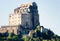
The Sacra di San Michele, sometimes known as Saint Michael's Abbey, is a religious complex on Mount Pirchiriano, situated on the south side of the Val di Susa ![]() overlooking the villages of Avigliana
overlooking the villages of Avigliana ![]() and Chiusa di San Michele
and Chiusa di San Michele ![]() , northern Italy. The abbey, which for much of its history came under Benedictine rule, is now entrusted to the Rosminians. A special regional law acknowledges it as the "Symbolic monument of the Piedmont region". The book The Name of the Rose was inspired by this monumental abbey.
, northern Italy. The abbey, which for much of its history came under Benedictine rule, is now entrusted to the Rosminians. A special regional law acknowledges it as the "Symbolic monument of the Piedmont region". The book The Name of the Rose was inspired by this monumental abbey.
Little is known of the early years of the abbey. The oldest extant account is that of a monk, William, who lived here in the late 11th century and wrote a Chronicon Coenobii Sancti Michaelis de Clusa. He sets the foundation of the abbey in 966, but, in another passage, the same monk maintains that the construction began under the pontificate of Sylvester II (999-1003).
What is certain is that what is now the crypt was built in the late 10th century, as attested by the Byzantine influence in the niches, columns and arches. According to tradition, this building was constructed by the hermit Saint Giovanni Vincenzo at the behest of the archangel Michael to whom he was particularly devoted; and the building materials which the hermit had collected were transported miraculously to the top of the mountain.
In the following years a small edifice was added, which could house a small community of monks and some pilgrims.
Later the abbey developed under the Benedictine rule, with the construction of a separate building with guest-rooms for pilgrims following the popular Via Francigena ![]() and of a church-monastery (1015–1035), probably on the remains of the ancient Roman castrum.
and of a church-monastery (1015–1035), probably on the remains of the ancient Roman castrum.
Abbot Ermengardo (1099–1131) had a new large, 26 m-high basement built from the foot of the hill to its peak, on which a new church (the one still existing today) was added, including the surrounding structures.
The monastery fell into decline and was finally suppressed in 1622 by Pope Gregory XV. It remained abandoned until 1835, when King Charles Albert and the Pope asked Antonio Rosmini to restore and repopulate it. It is currently under the care Rosminians.
Art and architecture
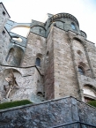
The church, whose construction lasted for many years, is characterized by the unusual position of the façade, which is at a lower level than the floor of the church's interior.
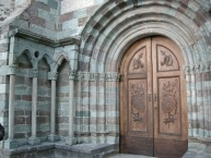
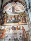
The 41 m-high façade gives access to the Scalone del Morti ("Stairway of the Dead"), flanked by arches, niches and tombs in which, until recent times, skeletons of dead monks where visible (hence the name). At the top of the steps is the marble Porta dello Zodiaco, a masterwork of 12th century sculpture. The church itself is accessed by a Romanesque portal in grey and green stone, built in the early 11th century. The church has a nave and two aisles, and features elements from both the Gothic and Romanesque styles of architecture. On the left wall is a large fresco portraying the Annunciation (1505), while in the Old Choir is a triptych by Defendente Ferrari.
The complex includes the ruins of the 12th-15th centuries monastery, which had five floors. It ends with the Torre della Bell'Alda ("Tower of the Beautiful Alda") The so-called "Monks' Sepulchre" is probably the remains of a chapel reproducing, in its octagonal plan, the Holy Sepulchre of Jerusalem.
Informationen zu Urheber-Rechten | |
|---|---|
Rechte-Ausprägung / Lizenz | by-sa: CREATIVE COMMONS Namensnennung, Weitergabe unter gleichen Bedingungen |
Link zur Rechtebeschreibung | |
Text(e) übernommen von: |
Wikipedia contributors, 'Sacra di San Michele', Wikipedia, The Free Encyclopedia, 31 March 2014, 18:05 UTC, <http://en.wikipedia.org/w/index.php?title=Sacra_di_San_Michele&oldid=602143287> [accessed 3 December 2014] |
übernommen / bearbeitet am | 03.12.2014
|
übernommen / bearbeitet durch |
|
Öffnungszeiten:
Winter timetable from October 16 to March 15
- Weekdays: 9.30-12.30, 14.30-17.00;
- Sundays and public holidays: 9.30-12.00, 14.30-17.30;
Summer timetable from March 16 to October 15
- Weekdays: 9.30-12.30, 14.30-18.00;
- Sundays and public olidays: 9.30-12.00, 14.30-18.30;
The last entry is allowed 30 minutes before closing
Closing day:
Monday, except public holidays
Radwege und Fahrrad-Touren in der Nähe
| Name/Bezeichnung | Typ | km zur Strecke |
|---|---|---|
Route | 0,7 km | |
Route | 0,7 km |
Erstellt am 03.12.2014,
zuletzt geändert von biroto-Redaktion am 03.12.2014