
Saint-Malo
Worth visiting
Added on 25 Apr 2015,
last edited by biroto-Redaktion on 13 Mar 2022
Nearby cycle routes and tours
| Route name | Type | Dist. to route |
|---|---|---|
Route | 0,2 km | |
Route | 0,2 km | |
Route | 3,6 km | |
Route | 3,6 km | |
Tour | 0,2 km | |
Tour | 0,2 km | |
Tour | 0,2 km | |
Tour | 0,2 km | |
Tour | 0,2 km | |
Tour | 0,4 km |
![]()
Please wait - map data are loading
Type of sights
Old town
Name and address
Saint-Malo
FR-35400 Saint-Malo
GEO-data
Geodetic coordinates
48.64∎∎∎∎ -2.02∎∎∎∎
Elevation
14 m
Communication
Information about copyright | |
|---|---|
Rights owner | |
Rights characteristic / license | by-sa: CREATIVE COMMONS Attribution-ShareAlike |
Link to the description of the license | |
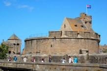
Image taken over from | commons.wikimedia.org/wiki/File:Chateau-de-Saint-Malo-DSC_6.jpg |
Image has been uploaded | by biroto-Redaktion on 25 Apr 2015
|
Information about copyright | |
|---|---|
Rights owner | |
Rights characteristic / license | by-sa: CREATIVE COMMONS Attribution-ShareAlike |
Link to the description of the license | |
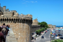
Image taken over from | commons.wikimedia.org/wiki/File:Remparts-st-malo-cote-port-.jpg |
Image has been uploaded | by biroto-Redaktion on 25 Apr 2015
|
Information about copyright | |
|---|---|
Rights owner | |
Rights characteristic / license | by-sa: CREATIVE COMMONS Attribution-ShareAlike |
Link to the description of the license | |
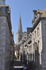
Image taken over from | commons.wikimedia.org/wiki/File:Saint-Malo_-_walled_city_04.jpg |
Image has been uploaded | by biroto-Redaktion on 25 Apr 2015
|
Information about copyright | |
|---|---|
Rights owner | |
Rights characteristic / license | by-sa: CREATIVE COMMONS Attribution-ShareAlike |
Link to the description of the license | |
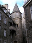
Image taken over from | commons.wikimedia.org/wiki/File:Saint-Malo_Maison_Anne_de_Bretagne.jpg |
Image has been uploaded | by biroto-Redaktion on 25 Apr 2015
|
Saint-Malo (French pronunciation: [sɛ̃.ma.lo]; Gallo : Saent-Malô; Breton: Sant-Maloù) is a walled port city in Brittany in northwestern France on the English Channel.
Traditionally with an independent streak, Saint-Malo was in the past notorious for piracy. Today it is a major tourist destination, with many ancient, attractive buildings.
Saint-Malo during the Middle Ages was a fortified island at the mouth of the Rance River ![]() , controlling not only the estuary but the open sea beyond. The promontory fort of Aleth, south of the modern centre in what is now the Saint-Servan
, controlling not only the estuary but the open sea beyond. The promontory fort of Aleth, south of the modern centre in what is now the Saint-Servan ![]() district, commanded approaches to the Rance even before the Romans, but modern Saint-Malo traces its origins to a monastic settlement founded by Saint Aaron and Saint Brendan early in the 6th century.
district, commanded approaches to the Rance even before the Romans, but modern Saint-Malo traces its origins to a monastic settlement founded by Saint Aaron and Saint Brendan early in the 6th century.
St. Malo is the setting of Marie de France's poem "Laustic", an 11th-century love story. Saint-Malo had a tradition of asserting its autonomy in dealings with the French authorities and even with the local Breton authorities. From 1590–1593, Saint-Malo declared itself to be an independent republic, taking the motto "not French, not Breton, but Malouins".
Saint-Malo became notorious as the home of the corsairs, French privateers and sometimes pirates. In the 19th century this "piratical" notoriety was portrayed in Jean Richepin's play Le flibustier and in César Cui's eponymous opera. The corsairs of Saint-Malo not only forced English ships passing up the Channel to pay tribute, but also brought wealth from further afield. In 1758 the Raid on St Malo ![]() saw a British expedition land intending to capture the town. However the British made no attempt on St Malo, and instead occupied the nearby town of St Servan
saw a British expedition land intending to capture the town. However the British made no attempt on St Malo, and instead occupied the nearby town of St Servan ![]() where they destroyed 30 privateers before departing.
where they destroyed 30 privateers before departing.
In World War II, during fighting in late August and early September 1944, the historic walled city of Saint-Malo was almost totally destroyed by U.S. shelling and bombing plus British naval gunfire. Saint-Malo was rebuilt over a 12-year period from 1948-1960.
Sites of interest
Now inseparably attached to the mainland, Saint-Malo is the most visited place in Brittany. Sites of interest include:
- The walled city (La Ville Intra-Muros)
- ⊙ The château of Saint-Malo, part of which is now the town museum.
- ⊙ The Solidor Tower
 in Saint-Servan is a 14th-century building that holds a collection tracing the history of voyages around Cape Horn . Many scale models, nautical instruments and objects made by the sailors during their crossing or brought back from foreign ports invoke thoughts of travel aboard extraordinary tall ships at the end of the 19th and the beginning of the 20th century.
 - The tomb of the writer Chateaubriand on the Ile du Grand Bé
- ⊙ The Petit Bé
- ⊙ The Cathedral of St. Vincent (Saint-Malo Cathedral )
- The Privateer's House ("La Demeure de Corsaire"), a ship-owner's town house built in 1725, shows objects from the history of privateering, weaponry and ship models.
- ⊙ The Great Aquarium Saint-Malo , one of the major aquaria in France.
- The labyrinthe du Corsaire, (an attraction park in Saint Malo)
- The Pointe de la Varde, Natural Park.
- The City of Alet, in front of Saint Malo Intra Muros.
- ⊙Fort National
- ⊙Fort de la Conchée
Sleep
Inside the range of 4 km:
- ⊙ Hôtel De l`Univers, Saint-Malo, PC VI
- ⊙ Hôtel Escale Oceania, Saint-Malo, PC V - IX
"... For parking we have places for cars (also for motorcycles or bicycles) at 20€ per place per night. Parking is secure in the basement of our hotel. We also have secure bike storage, the price of which is €5 per bike."
- ⊙ Chambres dʹhôtes Villa Saint Raphaël, Saint-Malo, PC VI - VII
"... I have a private garage to store bicycles which is closed."
- ⊙ Chambres dʹhôtes Lily Cottage, Saint-Malo, PC IV - V
Closed courtyard.
- ⊙ Chambres dʹhôtes Les Korrigans, Saint-Malo, PC V
"... we have a fully enclosed building at the foot of our garden to store bicycles or motorbikes, which can be locked with a key."
Useful
Inside the range of 4 km:
- ⊙ Ferry Saint-Malo - Dinard, Saint-Malo
- ⊙ Ferry Dinard - Saint-Malo, Dinard
Information about copyright
Rights characteristic / license
by-sa: CREATIVE COMMONS Attribution-ShareAlike
Link to the description of the license
Input taken over from:
Wikipedia contributors, 'Saint-Malo', Wikipedia, The Free Encyclopedia, 25 March 2015, 17:24 UTC, http://en.wikipedia.org/w/index.php?title=Saint-Malo&oldid=653484013
 [accessed 25 April 2015]
taken over / edited on
25 Apr 2015 - 13 Mar 2022
taken over / edited by
Nearby cycle routes and tours
Route name Type Dist. to route Route
0,2 km
Route
0,2 km
Route
3,6 km
Route
3,6 km
Tour
0,2 km
Tour
0,2 km
Tour
0,2 km
Tour
0,2 km
Tour
0,2 km
Tour
0,4 km
Added on 25 Apr 2015,
last edited by biroto-Redaktion on 13 Mar 2022
- ⊙ Chambres dʹhôtes Villa Saint Raphaël, Saint-Malo, PC VI - VII