
Donauversinkung
Worth visiting
Added on 08 Jan 2015,
last edited by biroto-Redaktion on 08 Jan 2015
Nearby cycle routes and tours
| Route name | Type | Dist. to route |
|---|---|---|
Route | 0,2 km | |
Route | 0,2 km | |
Route | 0,2 km | |
Route | 4,4 km | |
Route | 4,4 km | |
Route | 4,4 km | |
Tour | 0,2 km | |
Tour | 0,2 km | |
Tour | 0,2 km | |
Tour | 0,2 km | |
Tour | 4,4 km | |
Tour | 4,4 km | |
Tour | 4,4 km | |
Tour | 4,4 km | |
Tour | 4,9 km |
![]()
Please wait - map data are loading
Type of sights
Natural landmark
Name and address
Donauversinkung
∎∎∎∎∎∎∎∎∎∎∎ ∎∎∎∎∎∎∎
DE-78532 Tuttlingen
GEO-data
Geodetic coordinates
47.93∎∎∎∎ 8.76∎∎∎∎
Elevation
657 m
Communication
Information about copyright | |
|---|---|
Rights owner | |
Rights characteristic / license | cc0: Public Domain no Rights reserved |
Link to the description of the license | |
Image taken over from | https://commons.wikimedia.org/wiki/File:Donauversinkung-Schema.png |
Image has been uploaded | by biroto-Redaktion on 08 Jan 2015
|
Information about copyright | |
|---|---|
Rights owner | |
Rights characteristic / license | cc0: Public Domain no Rights reserved |
Link to the description of the license | |
Image taken over from | https://commons.wikimedia.org/wiki/File:Schluckloch-immendingen.jpg |
Image has been uploaded | by biroto-Redaktion on 08 Jan 2015
|
Information about copyright | |
|---|---|
Rights owner | |
Rights characteristic / license | cc0: Public Domain no Rights reserved |
Link to the description of the license | |
Image taken over from | |
Image has been uploaded | by biroto-Redaktion on 08 Jan 2015
|
Information about copyright | |
|---|---|
Rights owner | |
Rights characteristic / license | by-sa: CREATIVE COMMONS Attribution-ShareAlike |
Link to the description of the license | |
Image taken over from | https://commons.wikimedia.org/wiki/File:Donauversinkung_Schild.jpg |
Image has been uploaded | by biroto-Redaktion on 08 Jan 2015
|
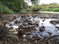
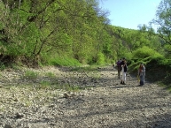
The Danube Sinkhole (German: Donauversinkung or Donauversickerung) is an incipient underground stream capture in the Upper Danube Nature Park. Between Immendingen ![]() and Möhringen and also near Fridingen
and Möhringen and also near Fridingen ![]() (Tuttlingen), the water of the Danube sinks into the riverbed in various places. The main sinkhole is next to a field named Brühl between Immendingen and Möhringen.
(Tuttlingen), the water of the Danube sinks into the riverbed in various places. The main sinkhole is next to a field named Brühl between Immendingen and Möhringen.
The sinking Danube water disappears into a karst water system of the well-stratified limestone formation (the ox2 layer) of the White Jura and appears again in a horizontal limestone layer (the ki4 layer), approximately twelve kilometers away at Aachtopf ![]() . It then flows as Radolfzeller Aach into Lake Constance at Radolfzell
. It then flows as Radolfzeller Aach into Lake Constance at Radolfzell ![]() . Thus, a part of the Danube water also flows into the Rhine. This geographical situation is a striking feature of the large European Watershed, which separates the catchment areas of the North Sea and the Black Sea.
. Thus, a part of the Danube water also flows into the Rhine. This geographical situation is a striking feature of the large European Watershed, which separates the catchment areas of the North Sea and the Black Sea.
The water flows out through a variety of small to very small cracks and crevices; the karst in these places is apparently at an early stage of development. The cave system of Aachtopf, that is the underground river Danube is, however, probably already well developed.
History
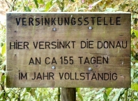
The first documented case of the Danube completely disappearing into the hole, dates back to 1874. Since then, the number of days per year when this happens, has risen sharply. Between 1884 and 1904, it happened, on average, 80 days per year. In 1922, it happened only on 29 days. In 1923, however, the number increased to 148. Between 1933 and 1937, the average was on 209; from 1938 to 1945, it was 270 days. The highest number so far, was in 1921, with 309 days.
Outlook
As the karst is developing, future sinkhole stretches are not exactly predictable. The underground river Danube annually removes about 7,000 tons of lime, that is 2,700 cubic meters, from the karst system. Future expansions or collapses in the underground system are conceivable; these would show above ground as sinkholes or ponors.
In the long run today's upper Danube will probably be redirected entirely into Radolfzeller Aach ![]() , and thus to the Rhine.
, and thus to the Rhine.
Information about copyright | |
|---|---|
Rights characteristic / license | by-sa: CREATIVE COMMONS Attribution-ShareAlike |
Link to the description of the license | |
Input taken over from: |
Wikipedia contributors, 'Danube Sinkhole', Wikipedia, The Free Encyclopedia, 15 December 2014, 02:57 UTC, <http://en.wikipedia.org/w/index.php?title=Danube_Sinkhole&oldid=638137322> [accessed 8 January 2015] |
taken over / edited on | 08 Jan 2015
|
taken over / edited by |
|
Nearby cycle routes and tours
| Route name | Type | Dist. to route |
|---|---|---|
Route | 0,2 km | |
Route | 0,2 km | |
Route | 0,2 km | |
Route | 4,4 km | |
Route | 4,4 km | |
Route | 4,4 km | |
Tour | 0,2 km | |
Tour | 0,2 km | |
Tour | 0,2 km | |
Tour | 0,2 km | |
Tour | 4,4 km | |
Tour | 4,4 km | |
Tour | 4,4 km | |
Tour | 4,4 km | |
Tour | 4,9 km |
Added on 08 Jan 2015,
last edited by biroto-Redaktion on 08 Jan 2015