
Mühlhausen
Worth visiting
Added on 20 Mar 2013,
last edited by biroto-Redaktion on 03 Feb 2020
Nearby cycle routes and tours
| Route name | Type | Dist. to route |
|---|---|---|
Route | 0,4 km | |
Route | 0,6 km | |
Tour | 0,0 km |
![]()
Please wait - map data are loading
Type of sights
Old town
Name and address
Mühlhausen
DE-99974 Mühlhausen
GEO-data
Geodetic coordinates
51.21∎∎∎∎ 10.45∎∎∎∎
Elevation
217 m
Communication
Information about copyright | |
|---|---|
Rights owner | |
Rights characteristic / license | by-sa: CREATIVE COMMONS Attribution-ShareAlike |
Link to the description of the license | |
Image taken over from | commons.wikimedia.org/wiki/File:Muehlhausen_untermarkt_ds_wv_09_2009.jpg |
Image has been uploaded | by biroto-Redaktion on 20 Mar 2013
|
Information about copyright | |
|---|---|
Rights owner | |
Rights characteristic / license | by-sa: CREATIVE COMMONS Attribution-ShareAlike |
Link to the description of the license | |
Image taken over from | |
Image has been uploaded | by biroto-Redaktion on 20 Mar 2013
|
Information about copyright | |
|---|---|
Rights owner | |
Rights characteristic / license | by-sa: CREATIVE COMMONS Attribution-ShareAlike |
Link to the description of the license | |
Image taken over from | |
Image has been uploaded | by biroto-Redaktion on 20 Mar 2013
|
Information about copyright | |
|---|---|
Rights owner | |
Rights characteristic / license | by-sa: CREATIVE COMMONS Attribution-ShareAlike |
Link to the description of the license | |
Image taken over from | |
Image has been uploaded | by biroto-Redaktion on 20 Mar 2013
|
Mühlhausen (official German long version Mühlhausen/Thüringen) is a city of 33,000 inhabitants in Thuringia, Germany. It is the capital of the Unstrut-Hainich district in the north-west of Thuringia, situated only 5 km (3 miles) north of Germany's accurate geographical centre (in the neighbouring municipality of Niederdorla ![]() ).
).
Mühlhausen was first mentioned in 967 and became one of the most important cities in central Germany during the later Middle Ages. In the mid-13th century, it became a Freie Reichsstadt, an independent and republican self-ruled member of the Holy Roman Empire, controlling an area of approximately 220 square kilometres (85 sq mi) and 19 regional villages. Due to its long-distance trade, Mühlhausen was prosperous and influential with a population of 10,000 around 1500. Because it was spared from later destruction, Mühlhausen today has a great variety of historical buildings with one of the largest medieval city centres remaining in Germany, covering a surface of more than 50 hectares within the inner city wall and approximately 200 hectares overall. There are eleven Gothic churches, several patricians’ houses and a nearly completely preserved fortification.
Johann Sebastian Bach worked as the city's organist in 1707/08. The theologian Thomas Müntzer, a leading person in the German Peasants' War, gave sermons here and was executed in front of the city. John A. Roebling, the constructor of the Brooklyn Bridge and Friedrich August Stüler, an influential architect in mid-19th century Prussia, were born in Mühlhausen.
Cityscape
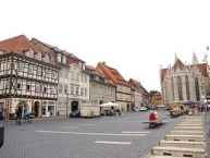
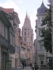
The historic city centre of Mühlhausen consists of three parts. Within the inner city wall are the old town (south of Schwemmnotte river around Untermarkt and St. Blaise's Church) and the new town (north of Schwemmnotte river around Obermarkt and St. Mary's Church). The former suburbiums of Mühlhausen are situated between the inner and the outer city walls. Like the inner city, they are of medieval origin, but in contrast from the core, this area was overbuilt often during the city's later history and today shows a mixture of old and new buildings. Within the inner city walls, most buildings date back to the Middle Ages. In the late 19th and the 20th century, the city grew into all directions and a relatively low density of buildings is typical for Mühlhausen, so that the built-up area is very large in relation to the number of inhabitants.
Characteristic for Mühlhausen's buildings is the predominant use of one kind of material – Travertine. It was found near the city in large quantities and is both light and solid, so that the Gothic churches with their filigree masonries and other important buildings could be built relatively cheaply. Nevertheless, many older citizens' houses were half-timbered constructions, with only the ground-floors made of stone.
Sights and architectural heritage
Churches and synagogue
Mühlhausen is primarily known for its large number of intact Gothic churches:
- St. Blaise's Church
 is the main church of the medieval old town at Untermarkt. It was built during the 13th century in early-Gothic style and is one of the most important 13th-century church buildings in Germany. It was first mentioned in 1227. The Teutonic Knights, owners of the church, had it expanded after 1270 using architects/builders from Maulbronn and Walkenried . Johann Sebastian Bach worked here in 1707/08 as organist. Today, it is the main Protestant parish church of Mühlhausen.
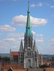
 - St. Mary's Church is the main church of the medieval new town at Obermarkt. It was built in the early 14th century in high-Gothic style and is Thuringia's second tallest church after the Erfurt Cathedral , sporting Thuringia's highest steeple (86 m). In 1975, the church was deconsecrated and is today used as a museum.
- All Saints Church at Steinweg was built in the late 13th century and has been a museum since 1989.
- St. Anthony's Chapel at Holzstraße was built in the 13th century and is a hostel today.
- Corn Market Church at Kornmarkt was built as a Franciscanian monastery c. 1250. The monastery was abandoned in 1568. In 1702-22 the church was redesigned in the baroque style. The last service was held here in 1802 after which the church became a warehouse. Since 1975 it has been used as a museum.
- St. Jacob's Church at Jakobistraße was built in the 14th century and hosts the city library today.
- St. Kilian's Church at Kiliansgraben was built during the 14th/15th century and hosts a theatre today.
- St. Peter and Paul's Churchbetween Steinweg and Mönchgasse was the church of the Dominican monastery, built in the early 14th century and demolished after a fire in 1689. Today, there are only a few walls remaining.
Synagogue: The Mühlhausen Synagogue at Jüdenstraße was first mentioned in 1380. Today's building is of younger origin: it was established in 1840/41 after the emancipation of the Jews in Prussia. The Synagogue was damaged during the pogrom of Kristallnacht in 1938, but it was one of only a few in Germany that survived the Nazi period and World War II. In 1998, it was reconsecrated and it is in use by the Jewish Community of Thuringia. It is also open for visitors.
Secular buildings
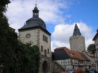
- The inner city walls were built during the 12th century with a length of 2,700 metres, a height of 8 metres and a thickness of 1.75 metres. They are mostly intact, with the exception of the most of the gates, laid down during the 19th century to improve traffic access. The only existing gates are the Frauentor in the west (inner and outer one), out of an original total of 23 gates. Next to the inner Frauentor stands the Rabenturm, which is accessible via the Wehrgang-Museum.
- The Ratshaus (town hall) at Ratsstraße is unusual, because it is not located in a square, not even on a main street but more inside a city block. It stretches across Ratsstraße with an arch. It was built after 1310 and several times expanded on until 1596.
- The Brotlaube (bread storage) is a large building at Obermarkt, first mentioned in 1304 and rebuilt after a fire in 1689. It was the market hall of the bakers. The façade mainly dates to 1722.
- The Order of the Teutonic Knights had two courts in Mühlhausen. The one in the old town at Untermarkt was rebuilt in 1720 and hosts the superintendenture today. The one in the new town next to St. Mary's Church was rebuilt during the 16th century. It was the residence of Thomas Müntzer and later the birthplace of Friedrich August Stüler.
- The Pfafferode Hospital is a large hospital complex within a park, built between 1910 and 1917 at the western edge of the city and is a typical example of the early-20th century sanatorium architecture in Germany.
- The Brunnenhaus Popperode is a small Renaissance building in the south-western periphery of Mühlhausen, built in 1614. The well was first mentioned in 1199 as part of the Medieval city's water supply.
- There are also many architecturally interesting citizens' and patricians' houses within the centre of Mühlhausen, especially along the Steinweg street and at the Untermarkt square.
Information about copyright | |
|---|---|
Rights characteristic / license | by-sa: CREATIVE COMMONS Attribution-ShareAlike |
Link to the description of the license | |
Input taken over from: |
Wikipedia contributors, 'Mühlhausen', Wikipedia, The Free Encyclopedia, 4 September 2014, 02:11 UTC, http://en.wikipedia.org/w/index.php?title=M%C3%BChlhausen&oldid=624100133 [accessed 18 September 2014] |
taken over / edited on | 18 Sep 2014 - 03 Feb 2020
|
taken over / edited by |
|
Nearby cycle routes and tours
| Route name | Type | Dist. to route |
|---|---|---|
Route | 0,4 km | |
Route | 0,6 km | |
Tour | 0,0 km |
Added on 20 Mar 2013,
last edited by biroto-Redaktion on 03 Feb 2020