
Gorinchem
Sehenswürdigkeiten
Erstellt am 03.05.2015,
zuletzt geändert von biroto-Redaktion am 16.07.2022
Radwege und Fahrrad-Touren in der Nähe
| Name/Bezeichnung | Typ | km zur Strecke |
|---|---|---|
Route | 0,1 km | |
Route | 0,1 km | |
Route | 0,2 km | |
Route | 0,2 km | |
Route | 1,6 km | |
Tour | 0,1 km | |
Tour | 0,2 km | |
Tour | 0,2 km |
![]()
Bitte warten - Kartendaten werden geladen
Art der Sehenswürdigkeit
Historische(s) Gebäude
Name u. Anschrift
Gorinchem
NL-4201 Gorinchem
GEO-Daten
GEO-Koordinaten
51.83∎∎∎∎ 4.97∎∎∎∎
Höhe
5 m
Kommunikation
Informationen zu Urheber-Rechten | |
|---|---|
Rechte-Inhaber | |
Rechte-Ausprägung / Lizenz | by-sa: CREATIVE COMMONS Namensnennung, Weitergabe unter gleichen Bedingungen |
Link zur Rechtebeschreibung | |
Bild übernommen aus | |
Bild hochgeladen | durch biroto-Redaktion am 03.05.2015
|
Informationen zu Urheber-Rechten | |
|---|---|
Rechte-Inhaber | |
Rechte-Ausprägung / Lizenz | by-sa: CREATIVE COMMONS Namensnennung, Weitergabe unter gleichen Bedingungen |
Link zur Rechtebeschreibung | |
Bild übernommen aus | |
Bild hochgeladen | durch biroto-Redaktion am 03.05.2015
|
Informationen zu Urheber-Rechten | |
|---|---|
Rechte-Inhaber | |
Rechte-Ausprägung / Lizenz | cc0: Public Domain keine Rechte vorbehalten |
Link zur Rechtebeschreibung | |
Bild übernommen aus | commons.wikimedia.org/wiki/File:Dit_is_In_Bethlehem_Gorinchem_small.jpg |
Bild hochgeladen | durch biroto-Redaktion am 03.05.2015
|
Informationen zu Urheber-Rechten | |
|---|---|
Rechte-Inhaber | |
Rechte-Ausprägung / Lizenz | by-sa: CREATIVE COMMONS Namensnennung, Weitergabe unter gleichen Bedingungen |
Link zur Rechtebeschreibung | |
Bild übernommen aus | en.wikipedia.org/wiki/File:Gorinchem,_monumentaal_pand_2006-06-13_15.14.JPG |
Bild hochgeladen | durch biroto-Redaktion am 03.05.2015
|
Gorinchem ist eine Festungsstadt im Osten der niederländischen Provinz Zuid-Holland. Sie liegt am Waal, einem Arm des Rhein.
Hintergrund
Schon um das Jahr 1000 war Gorinchem ein Bauern- und Fischerdorf. Es wird 1224 erstmals urkundlich bezeugt. Otto van Arkel verlieh dem bereits ummauerten Ort 1382 das Stadtrecht. Gorinchem kam, nach dem Aussterben des Geschlechtes Van Arkel, 1417 an Holland, was den Handel der Stadt begünstigte.
Im Jahre 1566 wurde die Stadt protestantisch. Im Achtzigjährigen Krieg fiel Gorcum 1572 an die aufständischen Holländer, wobei es zu einem Massaker kam: Neunzehn katholische Geistliche wurden, weil sie sich nicht zur neuen Lehre bekehren wollten, von den Geusen abtransportiert und später erhängt. Diese Opfer der damaligen Intoleranz werden – heutzutage auch von vielen Protestanten – als die Gorkumer Martelaren (Märtyrer) bezeichnet. Sie wurden am 24. November 1675 durch Papst Clemens X. seliggesprochen. Am 29. Juni 1867 erfolgte die Heiligsprechung durch Papst Pius IX. Der bekannteste unter ihnen ist Theodor van der Eem. In der Sankt Nikolauskirche von Brüssel werden die Reliquien der Märtyrer von Gorkum verehrt. Ihr Gedenktag ist der 9. Juli.
Im Jahre 1609 wurde die neue Stadtbefestigung fertiggestellt.
Das 18. Jahrhundert war für Gorinchem eine Epoche des wirtschaftlichen Rückganges. Als preußische Truppen es 1814 von den Franzosen befreien wollten, entbrannten heftige Kämpfe, bei denen viele Menschen starben und Kriegsschäden entstanden. Ab etwa 1860, als die Eisenbahn gebaut wurde und neue Land- und Wasserstraßen entstanden, begann wieder eine Blütezeit.
Sehenswürdigkeiten
- Die ⊙Grote Kerk ist die Hauptkirche von Gorinchem. Sie wurde im 19. Jahrhundert gebaut, viel älter aber ist der 67 m hohe Turm, der im 15. Jahrhundert entstanden ist und die Zerstörung der Vorgängerkirche überlebte. Von Mai bis September kann man ihn jeden Samstag besteigen, von oben hat man schöne Aussicht auf die Stadt.
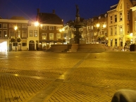
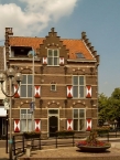
- Das ⊙ ehemalige Rathaus steht am Grote Markt (Großer Markt), einem Platz, der von historischen Häusern umrahmt wird. Inzwischen ist das Rathaus umgezogen und das Gebäude beherbergt das Gorcums Museum, ein Museum, dass Ausstellungen zur Stadtgeschichte zeigt.
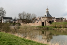
- Das ⊙Dalempoort ist das einzige historische Stadttor der Stadt. Über dem Tor steht ein kleines Ziegelgebäude mit Uhrenturm.
- Die Innenstadt von Gorinchem ist von Festungswällen umgeben. Teile wurden leider bebaut, doch vielerorts sind die Wälle Grünanlagen. An mehreren Stellen stehen Kanonen und es gibt hier zwei Windmühlen (siehe unten).
- Die ⊙Windmühle De Hoop ist ein steinerner Galerieholländer. Sie steht an den Festungswällen und kann besichtigt werden, wenn sie sich dreht.
Mittwochs von 13:00 bis 17:00 Uhr und samstags von 10:00 bis 17:00 Uhr geöffnet. - Die ⊙Windmühle Nooit Volmaarkt steht im Norden der Festungswälle und beherbergt ein Geschäft.
Mittwochs von 13:00 bis 17:00 Uhr und samstags von 10:00 bis 17:00 Uhr geöffnet.
Informationen zu Urheber-Rechten | |
|---|---|
Rechte-Ausprägung / Lizenz | by-sa: CREATIVE COMMONS Namensnennung, Weitergabe unter gleichen Bedingungen |
Link zur Rechtebeschreibung | |
Text(e) übernommen von: |
Wikivoyage-Bearbeiter, 'Gorinchem', Wikivoyage, Freie Reiseinformationen rund um die Welt, 6. Mai 2022, 13:43 UTC, https://de.wikivoyage.org/w/index.php?title=Gorinchem&oldid=1456325 |
übernommen / bearbeitet am | 16.07.2022
|
übernommen / bearbeitet durch |
|
Radwege und Fahrrad-Touren in der Nähe
| Name/Bezeichnung | Typ | km zur Strecke |
|---|---|---|
Route | 0,1 km | |
Route | 0,1 km | |
Route | 0,2 km | |
Route | 0,2 km | |
Route | 1,6 km | |
Tour | 0,1 km | |
Tour | 0,2 km | |
Tour | 0,2 km |
Erstellt am 03.05.2015,
zuletzt geändert von biroto-Redaktion am 16.07.2022