Navarrete
Worth visiting
Added on 14 Mar 2015,
last edited by »biroto-Redaktion« on 08 Dec 2022
Nearby cycle routes and tours
| Route name | Type | Dist. to route |
|---|---|---|
Route | 0,0 km | |
Route | 0,0 km | |
Route | 0,0 km | |
Tour | 0,0 km | |
Tour | 0,0 km | |
Tour | 0,0 km | |
Tour | 0,0 km | |
Tour | 0,1 km | |
Tour | 0,3 km | |
Tour | 4,4 km | |
Tour | 4,4 km | |
Tour | 4,4 km |
![]()
Please wait - map data are loading
Type of sights
Heritage building(s)
Name and address
Navarrete
ES-26370 Navarrete
GEO-data
Geodetic coordinates
42.429811 -2.561961
Elevation
517 m
Communication


Navarrete is a municipality of the autonomous community of La Rioja, with a population of 2,996 (2021). Named a conjunto histórico of Spain, Navarrete is located between Logroño and Nájera
on the Way of St. James, a medieval pilgrim route.
Alfonso VIII of Castile proposed to the inhabitants of the old villages of the zone that they relocate in a defensive place. These villages were known by the name of Corcuetos and their names were: San Llorente, San Antolín, San Pedro and Nuestra Señora del Prado. Their population settled around a castle raised on Tedeón hill, thus founding the new villa of Navarrete. The castle was fortified and protected with a small wall, that enclosed the settlement and it defended it from the possible attacks that threatened from the north.
In 1192 important fueros were granted to the inhabitants of the new settlement. These fueros, or charter, gave rise to the use in common of river waters and the collective exploitation of grass lands and woods to the east of the town. The charter also allowed for the establishment of local markets and fairs. Thanks to these privileges, the villa reached a great importance.
In 1367 a battle took place in the locality which is sometimes called the Battle of Navarrete, but is better known as the Battle of Nájera.
Places of interest
The historic centre is protected as a Conjunto histórico.
Buildings and monuments
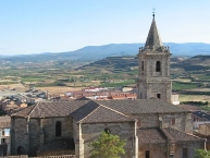
- Parish church of the Assumption (Asunción de María). Construction began in 1553 and finished in the 17th century. It consists of three naves and a baroque altarpiece.
- Hermitage of Santa Maria del Buen Suceso. Located to the south of the municipality, in the direction of Entrena
. The facade reliefs make references to the travellers of the Way of St. James.
- The Castle. This is the name given to the highest peak of the Cerro Tedeón on account of there once being a castle there. No trace of the castle now exists. There is a viewing point from which can be seen several towns and mountains.
Information about copyright | |
|---|---|
Rights characteristic / license | by-sa: CREATIVE COMMONS Attribution-ShareAlike |
Link to the description of the license | |
Input taken over from: |
Wikipedia contributors, 'Navarrete, La Rioja', Wikipedia, The Free Encyclopedia, 31 December 2014, 15:32 UTC, http://en.wikipedia.org/w/index.php?title=Navarrete,_La_Rioja&oldid=640392325 |
taken over / edited on | 14 Mar 2015 - 08 Dec 2022
|
taken over / edited by |
|
Nearby cycle routes and tours
| Route name | Type | Dist. to route |
|---|---|---|
Route | 0,0 km | |
Route | 0,0 km | |
Route | 0,0 km | |
Tour | 0,0 km | |
Tour | 0,0 km | |
Tour | 0,0 km | |
Tour | 0,0 km | |
Tour | 0,1 km | |
Tour | 0,3 km | |
Tour | 4,4 km | |
Tour | 4,4 km | |
Tour | 4,4 km |
Added on 14 Mar 2015,
last edited by »biroto-Redaktion« on 08 Dec 2022
