
Carrickfergus Castle
Worth visiting
Added on 15 Jan 2019,
last edited by biroto-Redaktion on 15 Jan 2019
Nearby cycle routes and tours
| Route name | Type | Dist. to route |
|---|---|---|
EuroVelo: Atlantic Coast Route - Part Scotland - Ireland - Wales | Route | 4,0 km |
Route | 4,5 km | |
Tour | 4,5 km |
![]()
Please wait - map data are loading
Type of sights
Castle/palace
Name and address
Carrickfergus Castle
∎∎∎∎∎∎ ∎∎∎∎∎∎∎
GB-BT38 8AA Carrickfergus
GEO-data
Geodetic coordinates
54.71∎∎∎∎ -5.80∎∎∎∎
Elevation
3 m
Communication
Information about copyright | |
|---|---|
Rights owner | |
Rights characteristic / license | by-sa: CREATIVE COMMONS Attribution-ShareAlike |
Link to the description of the license | |
Image taken over from | |
Image has been uploaded | by biroto-Redaktion on 15 Jan 2019
|
Information about copyright | |
|---|---|
Rights owner | https://www.panoramio.com/user/2824175?with_photo_id=21625684 |
Rights characteristic / license | by: CREATIVE COMMONS Attribution |
Link to the description of the license | |
Image taken over from | https://commons.wikimedia.org/wiki/File:Carrickfergus_Castle._-_panoramio.jpg |
Image has been uploaded | by biroto-Redaktion on 15 Jan 2019
|
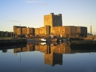
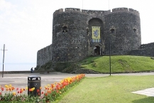
Carrickfergus Castle (from the Irish Carraig Ḟergus or "cairn of Fergus", the name "Fergus" meaning "strong man") is a Norman castle in Northern Ireland, situated in the town of Carrickfergus ![]() in County Antrim, on the northern shore of Belfast Lough. Besieged in turn by the Scottish, Irish, English and French, the castle played an important military role until 1928 and remains one of the best preserved medieval structures in Northern Ireland. It was strategically useful, with 3/4 of the castle perimeter surrounded by water (although in modern times only 1/3 is surrounded by water due to land reclamation).
in County Antrim, on the northern shore of Belfast Lough. Besieged in turn by the Scottish, Irish, English and French, the castle played an important military role until 1928 and remains one of the best preserved medieval structures in Northern Ireland. It was strategically useful, with 3/4 of the castle perimeter surrounded by water (although in modern times only 1/3 is surrounded by water due to land reclamation).
Carrickfergus was built by John de Courcy in 1177 as his headquarters, after he conquered eastern Ulster in 1177 and ruled as a petty king until 1204, when he was ousted by another Norman adventurer, Hugh de Lacy. Initially de Courcy built the inner ward, a small bailey at the end of the promontory with a high polygonal curtain wall and east gate. It had several buildings, including the great hall. From its strategic position on a rocky promontory, originally almost surrounded by sea, the castle commanded Carrickfergus Bay (later known as Belfast Lough), and the land approaches into the walled town that developed beneath its shadows.
Information about copyright | |
|---|---|
Rights characteristic / license | by-sa: CREATIVE COMMONS Attribution-ShareAlike |
Link to the description of the license | |
Input taken over from: |
Wikipedia contributors, 'Carrickfergus Castle', Wikipedia, The Free Encyclopedia, 31 December 2018, 22:59 UTC, <https://en.wikipedia.org/w/index.php?title=Carrickfergus_Castle&oldid=876222031> [accessed 15 January 2019] |
taken over / edited on | 15 Jan 2019
|
taken over / edited by |
|
Nearby cycle routes and tours
| Route name | Type | Dist. to route |
|---|---|---|
EuroVelo: Atlantic Coast Route - Part Scotland - Ireland - Wales | Route | 4,0 km |
Route | 4,5 km | |
Tour | 4,5 km |
Added on 15 Jan 2019,
last edited by biroto-Redaktion on 15 Jan 2019