
Landʹs End
Worth visiting
Added on 17 Apr 2017,
last edited by biroto-Redaktion on 24 Jan 2019
Nearby cycle routes and tours
| Route name | Type | Dist. to route |
|---|---|---|
Route | 0,3 km | |
Route | 0,4 km |
![]()
Please wait - map data are loading
Type of sights
Viewing point
Name and address
Landʹs End
∎∎∎∎∎ ∎∎∎
GB-AL10 0YB Landʹs End
GEO-data
Geodetic coordinates
50.06∎∎∎∎ -5.71∎∎∎∎
Elevation
37 m
Communication
Information about copyright | |
|---|---|
Rights owner | |
Rights characteristic / license | by-sa: CREATIVE COMMONS Attribution-ShareAlike |
Link to the description of the license | |
Image taken over from | https://commons.wikimedia.org/wiki/File:Land's_End,_Cornwall,_England.jpg |
Image has been uploaded | by biroto-Redaktion on 17 Apr 2017
|
Information about copyright | |
|---|---|
Rights owner | |
Rights characteristic / license | by: CREATIVE COMMONS Attribution |
Link to the description of the license | |
Image taken over from | |
Image has been uploaded | by biroto-Redaktion on 17 Apr 2017
|
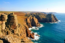
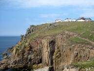
Land's End is the most Southwesterly point in Britain and part of Cornwall in the South West. It is not a town or village but rather a former small holding which now has an Visitor Complex with a Hotel, Visitor attractions and is well known for being the starting/ending point for the Land's End to John o'Groats ![]() journey.
journey.
Understand
Land's End's main represents both the starting and ending points of the longest journey in Great Britain, Land's End to John O'Groats. Consequently, it is known as "The First and Last", due to its position at the extremity of the UK. It is an atmospheric, dramatic piece of coastline steeped in history and romance.
See
- ⊙Lands End Visitor's Centre, Sennen, TR19 7AA, ☎ +44 8717 200044.
Do
- There is a Complex of Attractions on the site. A professional photographer takes photos of you in front of the signpost showing your hometown's distance (see photo above). He will charge you around £10 for the photos. There is a fence around the signpost, but you can, and many people do, just take their own photos standing in front of the fence.
- Walk East along the coast to the first promontory. The sea arch is visible along with the extraordinary rock formations in this area (weathered Granite). The coast path continues on to Porthgwarra past various coves, many caves, another sea arch and possibly some of the most dramatic coastline in the entire UK. An extended walk will reach Porthcurno where there is a bus service.
Information about copyright | |
|---|---|
Rights characteristic / license | by-sa: CREATIVE COMMONS Attribution-ShareAlike |
Link to the description of the license | |
Input taken over from: |
Wikivoyage contributors, 'Land's End', Wikivoyage, The FREE worldwide travel guide that anyone can edit, 15 January 2019, 19:45 UTC, <https://en.wikivoyage.org/w/index.php?title=Land%27s_End&oldid=3707144> [accessed 24 January 2019] |
taken over / edited on | 17 Apr 2017 - 24 Jan 2019
|
taken over / edited by |
|
Nearby cycle routes and tours
| Route name | Type | Dist. to route |
|---|---|---|
Route | 0,3 km | |
Route | 0,4 km |
Added on 17 Apr 2017,
last edited by biroto-Redaktion on 24 Jan 2019