
Cycle Route Lechtal-Radweg
No. of cycle route R9
Actions
![]()
Please wait - map data are loading
Added on 28 Jan 2013,
last edited by biroto-Redaktion on 20 Sep 2022
Actions
Cycle route metrics
Total distance in km
61
Information about rights to the gps-track data | |
|---|---|
Rights owner | OpenStreetMap and Contributors + biroto-Redaktion (biroto.eu) |
Rights characteristic / license | Contains information from OpenStreetMap, which is made available here under the Open Database License(ODbL) |
Link to the description of the license | |
GPX file taken from | |
GPX file uploaded | by biroto-Redaktion on 20 Sep 2022
|
Track points in total
1.384
Track points per km (avg)
23
Start/endpoint
Start location
Steeg, Tirol, AT (1116 m NHN)
End location
Pinswang, Tirol, AT (811 m NHN)
Travel reports about cycle tours
Information about copyright | |
|---|---|
Rights owner | |
Rights characteristic / license | by-sa: CREATIVE COMMONS Attribution-ShareAlike |
Link to the description of the license | |
Image has been uploaded | by Ottocolor on 16 Nov 2013
|
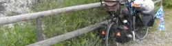
07 Aug 2013
75 km
A stage of the tour »Tour in the Alps 2013« of user Ottocolor
Beds4Cyclists, worth visiting and infrastructure
Name and address
Latitude / Longitude
Phone
Fax
Mobile
Type of accommodation
Rating for cyclists
Route km
Dist. to route
Elevation
50 km
1,9 km
1.070 m
Information about copyright | |
|---|---|
Rights owner | |
Rights characteristic / license | cc0: Public Domain no Rights reserved |
Link to the description of the license | |
Image taken over from | |
Image has been uploaded | by biroto-Redaktion on 27 Jul 2012
|
Information about copyright | |
|---|---|
Rights owner | |
Rights characteristic / license | cc0: Public Domain no Rights reserved |
Link to the description of the license | |
Image taken over from | |
Image has been uploaded | by biroto-Redaktion on 27 Jul 2012
|
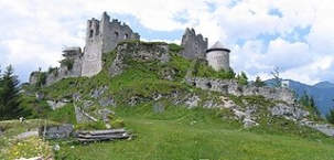
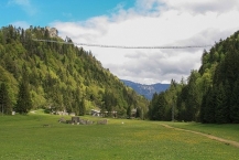
Die Ruine der Burg Ehrenberg liegt in 1100 m Höhe südlich über Reutte ![]() im Außerfern
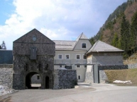
im Außerfern ![]() in Tirol. Die Burgruine ist der Mittelpunkt eines der bedeutendsten Festungsensembles Mitteleuropas. Die Burg wird von der barocken Festung Schlosskopf
in Tirol. Die Burgruine ist der Mittelpunkt eines der bedeutendsten Festungsensembles Mitteleuropas. Die Burg wird von der barocken Festung Schlosskopf ![]() überragt, unterhalb sperrt die Ehrenberger Klause das Tal. Östlich der Bundesstraße vervollständigt das Fort Claudia
überragt, unterhalb sperrt die Ehrenberger Klause das Tal. Östlich der Bundesstraße vervollständigt das Fort Claudia ![]() das Befestigungssystem.
das Befestigungssystem.
Information about copyright | |
|---|---|
Rights characteristic / license | by-sa: CREATIVE COMMONS Attribution-ShareAlike |
Link to the description of the license | |
Input taken over from: |
Seite „Burg Ehrenberg (Reutte)“. In: Wikipedia, Die freie Enzyklopädie. Bearbeitungsstand: 13. Juli 2012, 20:26 UTC. URL: http://de.wikipedia.org/w/index.php?title=Burg_Ehrenberg_(Reutte)&oldid=105543935 (Abgerufen: 27. Juli 2012, 16:38 UTC) |
taken over / edited on | 27 Jul 2012
|
taken over / edited by |
|
50 km
2,0 km
957 m
Information about copyright | |
|---|---|
Rights owner | |
Rights characteristic / license | by-sa: CREATIVE COMMONS Attribution-ShareAlike |
Link to the description of the license | |
Image taken over from | |
Image has been uploaded | by biroto-Redaktion on 05 Dec 2018
|
Information about copyright | |
|---|---|
Rights owner | https://commons.wikimedia.org/w/index.php?title=User:AmaliaSchoppengerd |
Rights characteristic / license | by-sa: CREATIVE COMMONS Attribution-ShareAlike |
Link to the description of the license | |
Image taken over from | https://commons.wikimedia.org/wiki/File:Highline179_nach_Fertigstellung.jpg |
Image has been uploaded | by biroto-Redaktion on 05 Dec 2018
|
Information about copyright | |
|---|---|
Rights owner | https://www.panoramio.com/user/969909?with_photo_id=118680644 |
Rights characteristic / license | by: CREATIVE COMMONS Attribution |
Link to the description of the license | |
Image taken over from | https://commons.wikimedia.org/wiki/File:Reutte,_Austria_-_panoramio_(7).jpg |
Image has been uploaded | by biroto-Redaktion on 05 Dec 2018
|
Information about copyright | |
|---|---|
Rights owner | |
Rights characteristic / license | by-sa: CREATIVE COMMONS Attribution-ShareAlike |
Link to the description of the license | |
Image taken over from | https://commons.wikimedia.org/wiki/File:Highline_179_(26549087533).jpg |
Image has been uploaded | by biroto-Redaktion on 05 Dec 2018
|
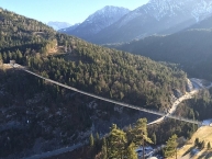
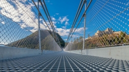
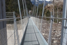
Die highline179 ist eine Fußgänger-Hängebrücke in Form einer Seilbrücke über die Fernpassstraße B 179 südlich von Reutte ![]() in Tirol
in Tirol ![]() (Österreich). Sie erstreckt sich in einer Höhe von 113 bis 114 m über die Burgenwelt Ehrenberg und verbindet die Ruine Ehrenberg
(Österreich). Sie erstreckt sich in einer Höhe von 113 bis 114 m über die Burgenwelt Ehrenberg und verbindet die Ruine Ehrenberg ![]() mit dem Fort Claudia. Die Lage der Brücke wurde so gewählt, dass sie mit einer Spannweite von 406 m zum Zeitpunkt der Fertigstellung eine der längsten Fußgängerhängebrücken der Welt war. Sie dient damit nicht nur der leichteren Besichtigung der beiden Burgruinen, sondern soll vor allem eine eigenständige Touristenattraktion für die Gemeinde Reutte sein.
mit dem Fort Claudia. Die Lage der Brücke wurde so gewählt, dass sie mit einer Spannweite von 406 m zum Zeitpunkt der Fertigstellung eine der längsten Fußgängerhängebrücken der Welt war. Sie dient damit nicht nur der leichteren Besichtigung der beiden Burgruinen, sondern soll vor allem eine eigenständige Touristenattraktion für die Gemeinde Reutte sein.
Der 1,20 m breite Fußgängersteg besteht aus einem Gitterrost, der auf Querstreben aufliegt, die über senkrechte Hänger an den vier Tragseilen mit einem Durchmesser von je 60 mm befestigt sind. Zu beiden Seiten der Lauffläche ist ein 1,35 m hoher Handlauf montiert, der mit dem Gitterrost durch ein Maschendrahtgitter verbunden ist. Die Tragseile sind auf beiden Seiten der Brücke mit insgesamt 16 Ankern befestigt, die bis in eine Tiefe von 17 m in den Fels reichen. Das Eigengewicht der Brücke beträgt rund 70 Tonnen.
Das eine Ende der Brücke liegt 9,85 m höher als das andere Ende. Der Fußgängersteg hängt gegenüber einer gedachten geraden Linie zwischen den beiden Enden um 17 m durch, wobei der Durchhang sich in Abhängigkeit von der Belastung und der Temperatur um rund einen Meter vergrößern kann. Die Tragfähigkeit beträgt 1000 Personen, aus Sicherheitsgründen dürfen jedoch nur 500 Personen gleichzeitig auf der Brücke sein, was durch Drehkreuzanlagen an beiden Enden sichergestellt wird. Für die Benutzung der privat finanzierten Brücke wird ein Eintrittspreis erhoben, der bei Unterschreiten einer Mindestnutzung durch eine Haftung der Gemeinde abgefedert wird.
Information about copyright | |
|---|---|
Rights characteristic / license | by-sa: CREATIVE COMMONS Attribution-ShareAlike |
Link to the description of the license | |
Input taken over from: |
Seite „Highline179“. In: Wikipedia, Die freie Enzyklopädie. Bearbeitungsstand: 12. Oktober 2018, 09:49 UTC. URL: https://de.wikipedia.org/w/index.php?title=Highline179&oldid=181719968 (Abgerufen: 5. Dezember 2018, 22:14 UTC) |
taken over / edited on | 05 Dec 2018
|
taken over / edited by |
|
50 km
0,5 km
858 m
52 km
0,3 km
844 m
52 km
0,6 km
852 m
![]()