
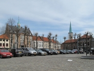
Flanders Cycle Route
former cycle route!
Actions
![]()
Please wait - map data are loading
Added on 24 Oct 2011,
on 14 Apr 2024
Actions
Cycle route metrics
Total distance in km
52
Information about rights to the gps-track data | |
|---|---|
Rights owner | OpenStreetMap and Contributors + biroto-Redaktion (biroto.eu) |
Rights characteristic / license | Contains information from OpenStreetMap, which is made available here under the Open Database License(ODbL) |
Link to the description of the license | |
GPX file taken from | |
GPX file uploaded | by biroto-Redaktion on 25 Nov 2020
|
Track points in total
681
Track points per km (avg)
13
Start/endpoint
Start location
Kinrooi, Flanders, BE (24 m NHN)
End location
Riemst, Flanders, BE (61 m NHN)
Signposting
The signage has been removed.
Sources of information
Bücher:
- Esterbauer bikeline: Flandern - Route: Rundtour durch den Norden Belgiens. Radtourenbuch und Karte 1:75.000, 800 km, wetterfest/reißfest
Connecting cycle path
- Flandern-Route Riemst - Alveringem
- Flandern-Route Maasgouw - Damme
Remarks
LF7 has been discontinue.
Beds4Cyclists, worth visiting and infrastructure
Name and address
Latitude / Longitude
Phone
Fax
Mobile
Type of accommodation
Rating for cyclists
Route km
Dist. to route
Elevation
0 km
0,7 km
24 m
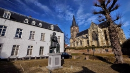
Thorn is a town in the municipality of Maasgouw, in the Dutch province of Limburg. It lies on the rivers Meuse and Witbeek. It is known as 'the white village' for its white-washed brick houses in the centre of town.
History
First, the region of Thorn was a swamp nearby the Roman road between Maastricht ![]() and Nijmegen
and Nijmegen ![]() . But the region had been drained and about 975, Bishop Ansfried of Utrecht founded a Benedictine nunnery. This monastery developed since the 12th century into a secular stift or convent. The principal of the stift was the abbess. She was assisted by a chapter of at most twenty ladies of the highest nobility.
. But the region had been drained and about 975, Bishop Ansfried of Utrecht founded a Benedictine nunnery. This monastery developed since the 12th century into a secular stift or convent. The principal of the stift was the abbess. She was assisted by a chapter of at most twenty ladies of the highest nobility.
Previously the abbess and the chapter were endowed with religious tasks but, since the 12th century, they served secular matters and formed the government of a truly sovereign miniature principality, the smallest independent state in the German Holy Roman Empire, approximately 250 x 250 metres. Besides Thorn, Ittervoort ![]() , Grathem
, Grathem ![]() , Baexem
, Baexem ![]() , Stramproy
, Stramproy ![]() , Ell
, Ell ![]() , Haler
, Haler ![]() and Molenbeersel belonged to this principality. After the French invasion in the winter of 1794–95 and the formal abolition in 1797 made an end to the existence of the abbey and the principality of Thorn; Thorn was first part of the department of Meuse-Inférieure, and after the Vienna Congress it became a municipality of the United Kingdom of the Netherlands.
and Molenbeersel belonged to this principality. After the French invasion in the winter of 1794–95 and the formal abolition in 1797 made an end to the existence of the abbey and the principality of Thorn; Thorn was first part of the department of Meuse-Inférieure, and after the Vienna Congress it became a municipality of the United Kingdom of the Netherlands.
Information about copyright | |
|---|---|
Rights characteristic / license | by-sa: CREATIVE COMMONS Attribution-ShareAlike |
Link to the description of the license | |
Input taken over from: |
Wikipedia contributors, 'Thorn, Netherlands', Wikipedia, The Free Encyclopedia, 20 March 2019, 04:25 UTC, https://en.wikipedia.org/w/index.php?title=Thorn,_Netherlands&oldid=888595124 |
taken over / edited on | 15 Aug 2019 - 16 Jul 2022
|
taken over / edited by |
|
0 km
0,8 km
33 m
6 km
0,7 km
21 m
10 km
0,3 km
22 m
10 km
0,0 km
44 m
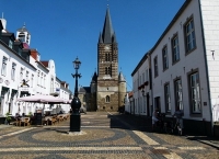
Maaseik (Limburgish: Mezeik) is a town and municipality in the Belgian province of Limburg. Both in size (close to 77 km²) as in population (around 25,000 inhabitants, of whom ca. 3,000 non-Belgian), it is the 8th largest municipality in Limburg. The town is the seat of the administrative arrondissement of Maaseik (kieskanton).
Understand
The town of Maaseik was probably founded around 1000, perhaps by the canons of nearby Aldeneik. It lay near the old Roman road that connected Maastricht and Nijmegen and was relatively safely situated in the valley of the Meuse. The village grew and became an important trading place in the Meuse region. Maaseik received its city charter in 1244. In the 14th century Loon was incorporated into the Bishopric of Liège and Maaseik became one of the 23 Liège Bonnes Villes.
As a typically planned town, the four main streets start at the marketplace and led to the four city gates, none of which has been preserved. The rectangular shape of the city walls is also typical. Against the western wall, a castle was built. The walls were dismantled however in 1467, when during the Liège Wars the Duke of Burgundy, Charles the Bold, attacked the Prince-Bishopric of Liège and destroyed many towns in the region.
Up till the 16th century Maaseik's economy was flourishing, thanks to commerce and the production of broadcloth. However, a large section of the population in these days were priests, canons, monks, nuns, beguines or beghards. Until the French Revolution, no fewer than six monasteries were present in the small town.
During the religious troubles of the 16th century, Maaseik was a stronghold for Anabaptism and almost broke away from Liège, but prince-bishop Gerard van Groesbeek was able to calm the people and retain the town.
Maaseik was besieged again in 1672 by Louis XIV. The walls, which had been rebuilt in the 16th century, were strengthened by Vauban during this period. The town suffered two disastrous fires in 1650 and 1684; the 1684 fire destroyed one third of the entire town which up till then largely consisted of wooden houses. After that the building of wooden houses was no longer permitted.
See
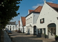
In Maaseik many buildings are protected as Beschermd erfgoed ![]() (National Heritage Sites). Notable are several churches and monasteries, mostly in Baroque and Neoclassical style, and a large number of houses in the local style of the Mosan Renaissance. Twelve watermills around Maaseik have been restored, some of which are still functioning and can be visited.
(National Heritage Sites). Notable are several churches and monasteries, mostly in Baroque and Neoclassical style, and a large number of houses in the local style of the Mosan Renaissance. Twelve watermills around Maaseik have been restored, some of which are still functioning and can be visited.
Churches, monasteries and listed houses
The main church of Maaseik is the Neoclassical ⊙Sint-Catharinakerk (Church of Saint Catherine), built in 1840-45. The predecessor of this church was for over 300 years the seat of a powerful religious institution, the chapter of Aldeneik, which was originally based at nearby Aldeneik Abbey ![]() , but in 1571 moved to Maaseik in order to escape the religious troubles of the period. The canons of Aldeneik took their treasures with them, which can now be seen in the sacristy of Saint Catherine's. In Aldeneik, all that remains of the once mighty abbey is the heavily restored Sint-Annakerk (Church of Saint Anne).
, but in 1571 moved to Maaseik in order to escape the religious troubles of the period. The canons of Aldeneik took their treasures with them, which can now be seen in the sacristy of Saint Catherine's. In Aldeneik, all that remains of the once mighty abbey is the heavily restored Sint-Annakerk (Church of Saint Anne).
Several monasteries from the Baroque era have been preserved in Maaseik. The most notable once are the monasteries of the ⊙Franciscans, the ⊙Capuchins and the ⊙Holy Cross Canons. The latter church (Kruisherenkerk) has a Rococo interior.
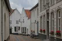
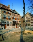
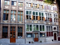
Maaseik, although a small town, boasts of many listed houses, predominantly in Mosan Renaissance style. Most of the houses are built in brick in combination with soft, yellowish Limburg chalk and a much harder, blueish limestone from the Ardennes region, locally called Naamse steen (Namur stone). Along Markt, Bosstraat, Hepperstraat and Grote Kerkstraat several beautifully adorned Mosan gables can be seen, many with original gable stones.
Market square
The main square and the true centre of Maaseik is the Markt (Market Square). On the North side of the square is the 18th-century town hall and a copy of the old perron, the symbol of judicial freedom of the prince-bishopric of Liège, placed in front of the town hall. The market place is surrounded by old houses, some of which are medieval in core but with 17th or 18th-century gables. Several buildings have been converted into pubs and restaurants and although the tree-lined square is still partly used as a car park, in Summer a number of street terraces give it a lively atmosphere.
Museums
- The ⊙church of Saint Catharine houses an important church treasure, which was originally in Aldeneik, but was moved to Maaseik in 1571 when the canons of Aldeneik fled to the safety of the walled town. The church treasury holds the oldest Gospel Book of the Benelux, the Codex Eyckensis, which dates from the early 8th century. The church treasure also includes ancient textiles, some of which are described as garments belonging to the local saints Herlindis and Relindis, and the oldest known embroidered Anglo-Saxon textiles from the 7th, 8th and 9th century. Other treasures in the museum collection are reliquaries, some dating back to the 9th and 10th century, liturgical vessels made of gold and silver, paraments, and ancient manuscripts.
- The ⊙Regionaal Archeologisch Museum (RAM) on Markt includes a museum of regional archeology and local history, and a pharmacy museum. The latter is considered the oldest pharmacy in Belgium and has retained most of its original display of Delftware pots and tin jars. Behind the museum is a small herbal garden.
- In the nearby Franciscan monastery the privately owned ⊙John Selbach Museum displays collections of art and antique dolls. The building also houses a permanent exhibition about the Van Eyck brothers and a scale model of the town as it was in 1672. The building is also used for large-scale exhibitions (in 2008 the Terracotta Army of Xian and in 2012 treasures from the Tang Dynasty).
Information about copyright | |
|---|---|
Rights characteristic / license | by-sa: CREATIVE COMMONS Attribution-ShareAlike |
Link to the description of the license | |
Input taken over from: |
Wikipedia contributors, 'Maaseik', Wikipedia, The Free Encyclopedia, 19 August 2020, 18:59 UTC, https://en.wikipedia.org/w/index.php?title=Maaseik&oldid=973875019 |
taken over / edited on | 07 Jan 2021 - 16 Jul 2022
|
taken over / edited by |
|
![]()