
Cycle Route Hilly Route
Actions
![]()
Please wait - map data are loading
Added on 30 Dec 2022,
last edited by biroto-Redaktion on 30 Dec 2022
Actions
Cycle route metrics
Total distance in km
459
Information about rights to the gps-track data | |
|---|---|
Rights owner | OpenStreetMap and Contributors + biroto-Redaktion (biroto.eu) |
Rights characteristic / license | Contains information from OpenStreetMap, which is made available here under the Open Database License(ODbL) |
Link to the description of the license | |
GPX file taken from | |
GPX file uploaded | by biroto-Redaktion on 30 Dec 2022
|
Track points in total
8.109
Track points per km (avg)
18
Start/endpoint
Start location
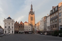
Poperinge, VLG, BE (22 m NHN)
End location
Plombières, WAL, BE (211 m NHN)
Signposting
|
|

Beds4Cyclists, worth visiting and infrastructure
Name and address
Latitude / Longitude
Phone
Fax
Mobile
Type of accommodation
Rating for cyclists
Route km
Dist. to route
Elevation
0 km
0,1 km
33 m
Information about copyright | |
|---|---|
Rights owner | |
Rights characteristic / license | by-sa: CREATIVE COMMONS Attribution-ShareAlike |
Link to the description of the license | |
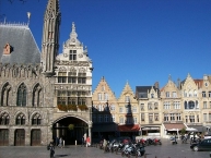
Image taken over from | https://commons.wikimedia.org/wiki/File:Poperinge_Town_Hall_and_Grote_Markt.jpg |
Image has been uploaded | by biroto-Redaktion on 18 Oct 2017
|
Information about copyright | |
|---|---|
Rights owner | https://commons.wikimedia.org/wiki/User:PIERRE_ANDRE_LECLERCQ |
Rights characteristic / license | by-sa: CREATIVE COMMONS Attribution-ShareAlike |
Link to the description of the license | |
Image taken over from | https://commons.wikimedia.org/wiki/File:Poperinge_Hallkerque_Sint-Janskerk_(Be).JPG |
Image has been uploaded | by biroto-Redaktion on 18 Oct 2017
|
Information about copyright | |
|---|---|
Rights owner | |
Rights characteristic / license | by-sa: CREATIVE COMMONS Attribution-ShareAlike |
Link to the description of the license | |
Image taken over from | https://commons.wikimedia.org/wiki/File:Hopmuseum_Poperinge_1.jpg |
Image has been uploaded | by biroto-Redaktion on 18 Oct 2017
|
Information about copyright | |
|---|---|
Rights owner | |
Rights characteristic / license | by-sa: CREATIVE COMMONS Attribution-ShareAlike |
Link to the description of the license | |
Image taken over from | https://commons.wikimedia.org/wiki/File:Poperinghe_Old_Military_Cemetery_5.JPG |
Image has been uploaded | by biroto-Redaktion on 18 Oct 2017
|
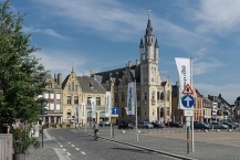
Poperinge is a charming town in the southwest corner of the province of West Flanders, close to the French border. The town of 20,000 inhabitants is mostly known for its World War I heritage sites and captivating beer culture with many hop fields in the surrounding area. In the last years Poperinge also has developed itself as a regional hub for cycling and hiking. The municipality consists besides Poperinge of six other communities: Haringe, Krombeke, Proven, Reningelst, Roesbrugge and Watou.
Understand
During World War I the battleground was only a few kilometers to sometimes just a few hundred meters away from Poperinge. The town however never got captured by the Germans and functioned as a posting station for the allied army forces going to or from the Ypres Salient. English soldiers that recalled the town for its amusement and prostitutes, named the town affectionately as "Pops". The many cemeteries in the region are a somber reminder of the thousands of soldiers that died in the surrounding countryside.
See
World War I sites
- ⊙Talbot House, Gasthuisstraat 43. Daily 10:00—17:30. Last entrance at 16:30. The ‘Every Man’s Club’ as Talbot House was called is one of the most evocative sites of the Great War. Over half a million soldiers were catered here. Everyone was treated equally as ranks did not matter here. Soldiers had the opportunity to play the piano, borrow books, to become human again. The exceptional spirit can possibly best be felt in the newly renovated 'Upper Room' or Chapel. This ‘Home away from Home’ makes a good way to look on the other side of World War I. €8, children till 6 years old go in for free. Combi-ticket Talbout House/Hopmuseum: €10. (updated May 2017)
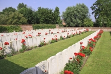
- ⊙Lijssenthoek Military Cemetery, Boescheepseweg 35A. Daily 9:00—18:00. This military cemetery is the prime witness of over four years of brutal fighting during World War I. Between 1915 and 1920 the hamlet of Lijssenthoek operated as the biggest evacuation hospital of the Ypres Salient. Next to the cemetery is a visitor center which provides a deeper understanding and impression of the history of the site. Free access.
 (updated May 2017)
 - ⊙Gwalia Cemetery, Elverdingseweg 22. A hop farm was claimed by the British army forces and called Gwalia Farm after a place in Wales. A small hospital was installed here. 470 army members who did not survive are buried on a cemetery on a plat behind the farm. Free access. (updated May 2017)
- ⊙Death Cells and Execution Spot, Guido Gezellestraat 1, ☎ +32 57 346676. The authentic execution pole which is situated in the inner courtyard of the town hall is a hurtful reminder of the fate that awaited so many so called 'deserters'. Soldiers, who sometimes bombarded for days, became near senseless and simply did not know what they were doing. Instead of receiving understanding and compassion, they served as a terrifying example to others. The condemned men spent their last night in the death cell before being shot at dawn on the courtyard. The site recently was renovated. Free. (updated Jun 2017)
- ⊙Nine Elms British Cemetery, Helleketelweg. 1615 war victims are buried here, of which 1593 are killed during the First World War and about 20 victims and 2 unidentified losses from the Second World War. (updated Jun 2017)
Other sights
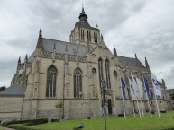
- ⊙St. John's church (Sint-Janskerk), Sint-Janskruisstraat 1. 13th century church which is a well-known place for pilgrimage dedicated to Our Lady. According to common beleifs, Our Lady performed a miracle here in 1479. This miracle is the basis for the yearly religious-historical procession, called Maria-Ommegang. (updated Jun 2017)
- ⊙St. Bertinus' church (Sint-Bertinuskerk), Garenstraat 1. Together with the St. John's church this one is very noticeable in the town of Poperinge. In the stained glasses of the church you can spot some local references, such as hops on the rood loft and depicted hop picking scenes. (updated Jun 2017)
- ⊙Town Hall, Grote Markt 1. The Poperinge Town Hall was built in 1911 by the same architect who later would be responsible of the reconstruction of Ypres after the world war. (updated Jun 2017)
- ⊙German Tower (Duitse Toren), Westvleterseweg. This 13m high German observation tower was built in 1940 during the Second World War as part of a military airfield (Fliegerhorst) just outside Poperinge. When the airfield closed in 1941 and became rural area again the tower fell out of use. Today the tower stands in the middle of the field and can only be seen from a short distance. (updated Jun 2017)
- ⊙Weeuwhof, Sint-Annastraat. On the location of a former hop field on the assignment of a canon 12 houses for widows (called weeuwen in the local dialect) and old single ladies were built. Later the complex was extended by 6 additional houses. (updated Jun 2017)
- ⊙Page Electronics, Casselstraat 210 (walk down the Casselstraat from the church), ☎ +32 57 346766. A local company assembling modern electronics, ranging from modules for spacecraft and aviation to prototypes for world famous research institute IMEC in Leuven
 . They offer free tours of the entire assembly line, giving a unique insight in how modern electronics are manufactured, including circuit boards, cabling, and assembly of complete products. Guided tours in English or Dutch only, with reservation. Tours take 3 - 4 hours, making it a great activity for the many rainy days in West Flanders. Free. (updated Sep 2017)
Beer and hop
- ⊙Hop Museum, Gasthuisstraat 71, ☎ +32 57 337922. From 25 February until 30 November Tue-Sun 10:00—18:00. Closed on Mondays. The Poperinge region has centuries of hop growing tradition. This tradition is showcased in this museum in the former building of the Municipal Scales (Stadsschaal). The whole process of hop growing is pictured and explained, along with historical documents, photographs and an audio guide. €6, €2,50 for people younger than 25, children till 6 years old go in for free. Combi-ticket Talbout House/Hopmuseum: €10. (updated May 2017)
Do
Beer and hop
- ⊙Brewery Sint-Bernardus, Trappistenweg 23, ☎ +32 57 388021. Tours are possible every day in English, Dutch and French. Since 1946 this brewery in the village of Watou produces dark and blond abbey ales with their own yeasts and malts. Their hops come from the hop field that is located right next to the brewery. €12,50. (updated Jun 2017)
- ⊙Brewery De Plukker, Elverdingseweg 16. Apr—Sept: Offer guided tours in Dutch for individuals or small groups on the first Saturday of the month at 15:00. This family owned brewery produces 5 beers, of which 3 are year round and 2 hop harvest beers. The brewery shop is opened on Saturday afternoons 14:00—17:00. There are also some selling points in the town center and in the wider region. During the tour it is possible to taste the beers. €6. (updated Jun 2017)
Information about copyright | |
|---|---|
Rights characteristic / license | by-sa: CREATIVE COMMONS Attribution-ShareAlike |
Link to the description of the license | |
Input taken over from: |
Wikivoyage contributors, 'Poperinge', Wikivoyage, The FREE worldwide travel guide that anyone can edit, 30 September 2017, 06:37 UTC, <https://en.wikivoyage.org/w/index.php?title=Poperinge&oldid=3288224> [accessed 18 October 2017] |
taken over / edited on | 18 Oct 2017 - 12 Apr 2018
|
taken over / edited by |
|
40 km
4,8 km
32 m
Information about copyright | |
|---|---|
Rights owner | Tony Grist |
Rights characteristic / license | cc0: Public Domain no Rights reserved |
Link to the description of the license | |
Image taken over from | https://commons.wikimedia.org/wiki/File:Grote_Markt,_Ieper.jpg |
Image has been uploaded | by biroto-Redaktion on 18 Oct 2017
|
Information about copyright | |
|---|---|
Rights owner | Tony Grist |
Rights characteristic / license | cc0: Public Domain no Rights reserved |
Link to the description of the license | |
Image taken over from | https://commons.wikimedia.org/wiki/File:Cloth_Hall,_Ieper_.jpg |
Image has been uploaded | by biroto-Redaktion on 18 Oct 2017
|
Information about copyright | |
|---|---|
Rights owner | |
Rights characteristic / license | by-sa: CREATIVE COMMONS Attribution-ShareAlike |
Link to the description of the license | |
Image taken over from | https://commons.wikimedia.org/wiki/File:Ypres_Sint-Maartenskathedraal.JPG |
Image has been uploaded | by biroto-Redaktion on 18 Oct 2017
|
Information about copyright | |
|---|---|
Rights owner | |
Rights characteristic / license | by-sa: CREATIVE COMMONS Attribution-ShareAlike |
Link to the description of the license | |
Image taken over from | https://commons.wikimedia.org/wiki/File:Ieper_Menenpoort_R03.jpg |
Image has been uploaded | by biroto-Redaktion on 18 Oct 2017
|
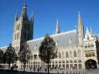
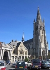
Ypres (Dutch: Ieper, both pronounced "eeper") is a friendly town of 35,000 inhabitants in Flanders endowed with wonderful architecture and a troubled past. Ypres is best known as the site of three major battles of the First World War, the most famous being the Battle of Passchendaele from July - November 1917. The many memorials and cemeteries of the fallen in and around Ypres draw thousands of visitors each year. The belfry of Ypres is a ![]() UNESCO World Heritage site.
UNESCO World Heritage site.
Understand
The town of Ypres formed the centre of the so-called "Ypres Salient" during most of the First World War - an area of Allied (British and Belgian)-held land surrounded on three sides by the German front line that formed the northernmost section of the Western Front. Holding Ypres was vital for the Allies in their bid to prevent the Germans gaining control of all the Channel ports, vital for the transport and supply of the British Expeditionary Force. As a result, the city became the focus of several major battles to break in / out of the Salient and was subjected to fairly continuous bombardment by German artillery for most of the war. By 1918, little remained of the town but shattered ruins surrounded by muddy shell-pocked fields.
After the First World War, most of central Ypres was rebuilt with German reparations (war debt) money. This was a lengthy process: the famous Cloth Hall was not completed until the 1960s.
See
Landmarks and Memorials
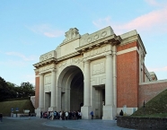
- ⊙Menin Gate Memorial. Dedicated on 24 July 1927 as a memorial to the missing British and Commonwealth soldiers who fell in Belgium during World War One. Has a Last Post Ceremony each night at 8:00 PM as a way for the Ypres citizens to express their gratitude towards those who died for Belgium's freedom.
- This memorial contains, both inside and out, huge panels into which are carved the names of the 54,896 officers and men of the British Empire forces who died in the Ypres Salient area and who have no known graves. The names recorded on the gate's panels are those of men who died in the area between the outbreak of the war in 1914 and 15 August 1917. The names of a further 34,984 of the missing - those who died between 16th August, 1917 and the end of the war, are recorded on carved panels at Tyne Cot Cemetery, on the slopes just below Passchendaele.
- Cloth Hall - originally built around 1200 as a center of Flemish wealth, completely destroyed by German artillery shelling in 1916, the Cloth Hall was rebuilt, the project completing in 1962 and the symbol of a resurgent city. Contains the In Flanders Fields Museum.
- ⊙In Flanders Fields Museum. Apr-Sept 10AM-6PM, Oct-Mar T-Su 10AM—5PM, last entry 1 hr before closing. Located in the Ypres Cloth Hall, right in the center. This museum gives an excellent overview of WWI. It is more like an experience that takes you right into the daily life during the war. The experience is very moving, and it's a must-see for everyone coming to Ypres, young and old. Allow at least 2h for a full museum visit. When the weather is good enough, the belfry tower is also available for visit for additional cost, giving you a great overview over the front region. adults €9, youths 18-25 yrs €4, children 7-18 yrs €1, under 7 free.
- City fortification. Ypres has been a rather military city from its foundation on, being always on the boundary of some country. The oldest city walls, dating from 1385, were mostly destroyed for expansion. The city walls that are currently guarding the south and east of the city were created by the French architect Vauban in the 16th century. The walls are star-shaped, and made from thick dirt moats, allowing to hold back the heaviest artillery from that age to WWI onwards. Planted with trees, they form a green belt around the city centre.
- ⊙Casemates (Kazematten) (Just a bit south of the Menin gate, with entrances to the inner-city.). The Casemates were bomb-free shelters under the city fortifications. Also build by Vauban, and they even remained functional as armoury until WWI. Currently, they're brought back into use. One of them contains a pub, another one contains a brewery, and the rest is used for temporal expositions.
- ⊙Ramparts Cemetery, Rijselstraat. Military cemetery located within the town of Ypres with 198 Commonwealth burials next to the Lille Gate (Rijselpoort).
Eat
The marketplace has several restaurants, pubs and places to sit outside during the summer.
Tuesdays usually host music night outside, organised by "'t Klein Stadhuis" right next to the cloth halls and the city hall.
Information about copyright | |
|---|---|
Rights characteristic / license | by-sa: CREATIVE COMMONS Attribution-ShareAlike |
Link to the description of the license | |
Input taken over from: |
Wikivoyage contributors, 'Ypres', Wikivoyage, The FREE worldwide travel guide that anyone can edit, 14 October 2017, 13:06 UTC, <https://en.wikivoyage.org/w/index.php?title=Ypres&oldid=3304833> [accessed 18 October 2017] |
taken over / edited on | 18 Oct 2017 - 12 Apr 2018
|
taken over / edited by |
|
86 km
0,1 km
19 m
Information about copyright | |
|---|---|
Rights owner | |
Rights characteristic / license | by-sa: CREATIVE COMMONS Attribution-ShareAlike |
Link to the description of the license | |
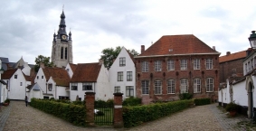
Image taken over from | https://commons.wikimedia.org/wiki/File:Courtrai_beguinage.jpg |
Image has been uploaded | by biroto-Redaktion on 14 Mar 2018
|
Information about copyright | |
|---|---|
Rights owner | |
Rights characteristic / license | by-sa: CREATIVE COMMONS Attribution-ShareAlike |
Link to the description of the license | |
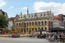
Image taken over from | https://commons.wikimedia.org/wiki/File:Kortrijk_Stadhuis_R01.jpg |
Image has been uploaded | by biroto-Redaktion on 14 Mar 2018
|
Information about copyright | |
|---|---|
Rights owner | |
Rights characteristic / license | by-sa: CREATIVE COMMONS Attribution-ShareAlike |
Link to the description of the license | |
Image taken over from | |
Image has been uploaded | by biroto-Redaktion on 14 Mar 2018
|
Information about copyright | |
|---|---|
Rights owner | |
Rights characteristic / license | by-sa: CREATIVE COMMONS Attribution-ShareAlike |
Link to the description of the license | |
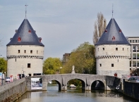
Image taken over from | https://commons.wikimedia.org/wiki/File:Kortrijk_Broeltürme_3.jpg |
Image has been uploaded | by biroto-Redaktion on 14 Mar 2018
|
Kortrijk (French: Courtrai, sometimes referred to in English as Courtray) is a city in Flanders, the northern part of Belgium. It is the capital and biggest city of the arrondissement of Kortrijk, which comprises some 284,581 inhabitants (1 January 2014). The wider municipality comprises the city of Kortrijk proper and the towns of Aalbeke, Bellegem, Bissegem, Heule, Kooigem, Marke, and Rollegem.
The city is situated on the Leie River, 42 km (26 miles) southwest of Ghent ![]() and 25 km (15 miles) northeast of Lille
and 25 km (15 miles) northeast of Lille ![]() in France. Both Kortrijk and Lille are part of the same transnational Eurodistrict urban area with around 1,900,000 inhabitants.
in France. Both Kortrijk and Lille are part of the same transnational Eurodistrict urban area with around 1,900,000 inhabitants.
As the biggest city of southern West Flanders, Kortrijk has many schools, a university, hospitals and shopping streets.
Understand
Kortrijk is a medium city, it has a good balance of tradition and innovation/modernism. It has always been famous for shopping, and in 2010 a big shopping centre was opened in the heart of the city. There are numerous traffic-free shopping zones, and lots historical sites in the city centre. Outside the centre there are some less developed hoods, but never really bad neighbourhoods.
Kortrijk is a rather safe city. Suburbs/satellite cities like Menen have to endure mainly burglary criminality from youth and gangsters, but Kortrijk is rather safe.
The city is known as the Guldensporenstad (City of the Golden Spurs), after the battle of the Golden Spurs in 1302. It used to be the centre of the linen industry and is still known as an important textile industry region.
See
Museums
- ⊙Kortrijk 1302, Begijnhofpark, ☎ +32 56 277850. May-Sept: Tue-Sun: 10:00—18:00. Closed on Mondays. Oct-Apr: Tue-Sun: 10:00—18:00. Closed on Mondays. An interactive museum showing you the Battle of the Golden Spurs (11th of July 1302). This battle is historical because it was one of the first battles where a peasant-based army defeated a knights army. After the battle, the spurs of the fallen horses were kept as a victory sign. The battle gave Flanders its regional holiday. €6 normal ticket. €4 reduced ticket. Free for children up to 12. (updated May 2017)
- Broelmuseum (Museum of Fine Arts). Situated in an old 18th-century mansion. Mostly contains regional artists (f.i. Roelant Savery) and an unique collection of ceramic. Closed for renewal. Will open in 2018 with a different name and concept. (updated May 2017)
- ⊙Texture (Museum of Flax and river Lys), Noordstraat 28, ☎ +32 56 277470. May-Sept: Tue-Sun: 10:00—18:00. Closed on Mondays. Oct-Apr: Tue-Sun: 10:00—17:00. Closed on Mondays. New museum that opened in 2014 on the banks of the Lys (Leie) river. Shows a historical image of the flax industry in Kortrijk and the surroundings. €6 normal ticket. €4 reduced ticket. Free for children up to 12. (updated May 2017)
- Groeninge Abbey.
- Agricultural Museum. In Bissegem.
Historical buildings
- ⊙City Hall (Stadhuis), ☎ +32 56 277000. (updated Jun 2017)
- ⊙Belfry (Belfort), Grote Markt.
 UNESCO World Heritage site
 - ⊙Begijnhof. The scenic beguinage (UNESCO-heritage) was founded in 1238 by Johanna Van Constantinopel. It was destroyed 3 times and rebuilt for the last time in the 17th century.
- ⊙Broeltorens. These two identical towers are remains of the medieval city wall. They are the typical image of Kortrijk. Build in the 13th and 15 century, they are located at both sides of the Leie river.
- Onze-Lieve-Vrouwehospitaal. Hospital, founded between 1200 and 1204.
- Baggaertshof. Medical garden and 13 old houses.
- ⊙Groeningepoort and Groeningekouter, Plein. The Groeningepoort gate is built in 1908 to commemorate the 600th anniversary of the Golden Spurs battle on the location of the Groeningekouter, the field of the battle took place. In the park that now covers a part of the former battle field, you can also find the Groeningemonument.
- ⊙Schouwburg, Schouwburgplein 14, ☎ +32 56 239855. A rather impressive, chateau-like building. Schouwburg is the Dutch word for theatre. (updated Jun 2017)
- ⊙The Wave Fountain (Fontein De Golf), Schouwburgplein (Near the theatre). Made by Olivier Strebelle.
Churches
Information about copyright | |
|---|---|
Rights characteristic / license | by-sa: CREATIVE COMMONS Attribution-ShareAlike |
Link to the description of the license | |
Input taken over from: |
Wikivoyage contributors, 'Kortrijk', Wikivoyage, The FREE worldwide travel guide that anyone can edit, 13 January 2019, 07:20 UTC, <https://en.wikivoyage.org/w/index.php?title=Kortrijk&oldid=3691741> [accessed 24 January 2019] |
taken over / edited on | 14 Mar 2018 - 24 Jan 2019
|
taken over / edited by |
|
96 km
1,4 km
28 m
146 km
0,8 km
36 m
![]()