
Cycle Route Along the Iskar River
No. of cycle route BP2
Actions
![]()
Please wait - map data are loading
Added on 02 Mar 2018,
last edited by biroto-Redaktion on 02 Nov 2023
Actions
Cycle route metrics
Total distance in km
290
Information about rights to the gps-track data | |
|---|---|
Rights owner | OpenStreetMap and Contributors + biroto-Redaktion (biroto.eu) |
Rights characteristic / license | Contains information from OpenStreetMap, which is made available here under the Open Database License(ODbL) |
Link to the description of the license | |
GPX file taken from | |
GPX file uploaded | by biroto-Redaktion on 02 Nov 2023
|
Track points in total
3.695
Track points per km (avg)
13
Start/endpoint
Start location
Самоков, BG (944 m NHN)
End location
Долна Митрополия, BG (34 m NHN)
Character
The Iskar River is one of the longest and definitely the most picturesque rivers in Bulgaria. Iskar Dam, Pancharevo Gorge and Iskar Gorge, the canyons of Kunino and Reselets offer exciting sights and enjoyable rides. The route takes 3 to 5 days, the main problem being the crossing of the Sofia area. The route can also be combined with other routes or certain sections - eg. Sofia - Samokov as an exit from Sofia to the valleys of Struma or Maritsa. Or to the north via Svoge and Mezdra, as the easiest way to cross the Stara Planina (Balkan) mountain to ride through Moesia or on EuroVelo 6.
Information about copyright | |
|---|---|
Rights characteristic / license | by-sa: CREATIVE COMMONS Attribution-ShareAlike |
Link to the description of the license | |
taken over / edited on | 02 Mar 2018 - 31 Dec 2020
|
taken over / edited by |
|
Landscape
Information about copyright | |
|---|---|
Rights characteristic / license | by-sa: CREATIVE COMMONS Attribution-ShareAlike |
Link to the description of the license | |
taken over / edited on | 02 Mar 2018 - 31 Dec 2020
|
taken over / edited by |
|
Signposting
The cycle route is not signposted.
Travel to and from ...
From/To start and ending point there is no rail road, but from Sofia city to Cherven Bryag (2/3 of road) there is a rail road.
Connecting cycle path
- At the northern end of this route EuroVelo 6 along the Danube river.
Beds4Cyclists, worth visiting and infrastructure
Name and address
Latitude / Longitude
Phone
Fax
Mobile
Type of accommodation
Rating for cyclists
Route km
Dist. to route
Elevation
66 km
0,6 km
552 m
67 km
0,1 km
549 m
185 km
0,7 km
197 m
Information about copyright | |
|---|---|
Rights owner | |
Rights characteristic / license | by-sa: CREATIVE COMMONS Attribution-ShareAlike |
Link to the description of the license | |
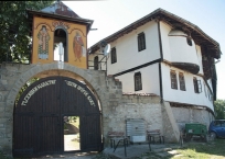
Image taken over from | https://commons.wikimedia.org/wiki/File:Tarzhiski_msnstir_entrance_door.jpg |
Image has been uploaded | by biroto-Redaktion on 31 Dec 2020
|
Information about copyright | |
|---|---|
Rights owner | |
Rights characteristic / license | by-sa: CREATIVE COMMONS Attribution-ShareAlike |
Link to the description of the license | |
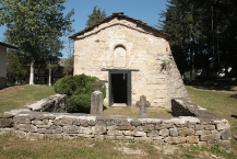
Image taken over from | https://commons.wikimedia.org/wiki/File:Saint_Nicolas_Church_in_Tazhistki_Monastery,_Bulgaria.JPG |
Image has been uploaded | by biroto-Redaktion on 31 Dec 2020
|