
Cycle Route ForeBalkan
No. of cycle route BP3
Actions
![]()
Please wait - map data are loading
Added on 30 Dec 2020,
last edited by biroto-Redaktion on 31 Dec 2020
Actions
Cycle route metrics
Total distance in km
983
Information about rights to the gps-track data | |
|---|---|
Rights owner | OpenStreetMap and Contributors + biroto-Redaktion (biroto.eu) |
Rights characteristic / license | Contains information from OpenStreetMap, which is made available here under the Open Database License(ODbL) |
Link to the description of the license | |
GPX file taken from | |
GPX file uploaded | by biroto-Redaktion on 30 Dec 2020
|
Track points in total
12.781
Track points per km (avg)
13
Start/endpoint
Start location
Vidin, BG (37 m NHN)
End location
Varna, BG (34 m NHN)
Character
Information about copyright | |
|---|---|
Rights characteristic / license | by-sa: CREATIVE COMMONS Attribution-ShareAlike |
Link to the description of the license | |
taken over / edited on | 30 Dec 2020
|
taken over / edited by |
|
Beds4Cyclists, worth visiting and infrastructure
Name and address
Latitude / Longitude
Phone
Fax
Mobile
Type of accommodation
Rating for cyclists
Route km
Dist. to route
Elevation
1 km
0,4 km
40 m
Information about copyright | |
|---|---|
Rights owner | |
Rights characteristic / license | by-sa: CREATIVE COMMONS Attribution-ShareAlike |
Link to the description of the license | |
Image taken over from | |
Image has been uploaded | by biroto-Redaktion on 02 Oct 2016
|
Information about copyright | |
|---|---|
Rights owner | |
Rights characteristic / license | by-sa: CREATIVE COMMONS Attribution-ShareAlike |
Link to the description of the license | |
Image taken over from | |
Image has been uploaded | by biroto-Redaktion on 02 Oct 2016
|
Information about copyright | |
|---|---|
Rights owner | |
Rights characteristic / license | by-sa: CREATIVE COMMONS Attribution-ShareAlike |
Link to the description of the license | |
Image taken over from | https://commons.wikimedia.org/wiki/File:St_Dimitar_Cathedral_(Vidin)_E4.jpg |
Image has been uploaded | by biroto-Redaktion on 02 Oct 2016
|
Information about copyright | |
|---|---|
Rights owner | |
Rights characteristic / license | by-sa: CREATIVE COMMONS Attribution-ShareAlike |
Link to the description of the license | |
Image taken over from | |
Image has been uploaded | by biroto-Redaktion on 02 Oct 2016
|
Vidin (Bulgarian: Видин) is a city in the northwest of Bulgaria, on the banks of Danube River, which is the borderline between Bulgaria and Romania. The northwest is infamously the poorest region in the country. Vidin is one of the oldest cities in Bulgaria, with a rich history. Its history begins in the 1st century when it was overcome by the Romans and became called Bononia. In 1396, the Ottomans defeated the last Bulgarian stronghold - the one in Vidin. They ruled there until 1878, when Vidin was liberated from the Turks. In 1942, Vidin experienced a flood due to the rising Danube. It was a great tragedy, but Vidin managed to overcome the problem with the flood, the diseases, and famine. Since then, Vidin has been an important military commercial and transport center for 200 years. There are many landmarks that exhibit the glorious past of Vidin: Baba Vida castle, the Vidin Synagogue (deserted after Jewish emigration to Israel), St. Petka church, the Osman Pazvantoglue mosque and library (built by the late Turkish ruler of northwestern Bulgaria in the 18th century), the Krastata Kazarma and St. Dimitar church.
Understand
Vidin is currently the poorest city in the EU, but it is a beautiful town with many historic and cultural landmarks. Tourism has experienced a decline except for groups that come along the Danube on cruises, but a visit to Vidin is definitely worth a visit. The people tend to be more hospitable here than in larger cities like Sofia. In Vidin, there is a foreign language school and young people can usually speak English well. In other schools students learn English, too. For elderly people, there is a language academy, usually teaching English or German. There are a lot of Vlachs (Bulgaro-Romanians), so knowing Romanian is always a plus! Many residents work on farms in nearby villages, raise domestic animals, and sow plants, and so this region is famous for its production of food.
Unfortunately, because of its economic issues, Vidin has many problems. Lack of funds has caused the sidewalks and streets to fall into disrepair, and many buildings are vacant and crumbling. There is no university in the northwest region, so young people mostly move to other cities or countries. There are many stray dogs and cats, but they are usually docile. Air pollution and littering are major issues, despite students’ attempts to clean the town. Vidin is, however, one of the safest cities in Bulgaria.
See
As of dec. 2015, The ONLY Tourist Information center is in the park near Danube shore, near Vidin Port, at the end of main pedestrian street, ul. Gradinska. They have some free bulgarian-english booklets with attractions and an useful black-white printed map with best tourist sites from city center, written in bulgarian, with few english notes. Warning: On the main street and other places in town you'll see Tourist Information signs with arrows, but they directs to a tourist site, not to a tourist information center.
There's an old, communist, but charming feel in many parts of the town and coming from Romania or other eastern block countries you'll feel nostalgic.
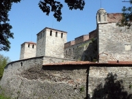
Vidin boasts two well-preserved medieval fortresses, Baba Vida—Vidin's main landmark, built in the period from the 10th to the 14th century—and Kaleto, as well as many old Orthodox churches such as St Pantaleimon, St Petka (both 17th century), and St Great Martyr Demetrius (19th century), a Jewish synagogue (1894), a mosque and a library of Osman Pazvantoğlu (late 18th century), the cruciform barracks of 1798, and a number of old Renaissance buildings.
- ⊙ Baba Vida Fortress (9h - 17h; tickets 4lv, under 14 free; combined daily ticket with Konaka museum: 5lv): This tenth century medieval castle is a wonderful attraction for children and adults. It is said to be the only entirely preserved medieval castle in the country. There you can see brilliant architecture and a lot of tools used during Bulgaria’s history like swords, bows, arrows, and others. On the upper part, you can sit in tranquility and enjoy a great view of the Danube and to the New Europe Bridge
 . Across from the entrance there are souvenir shops from which you can buy numerous Bulgarian and Baba Vida souvenirs. There is also a beach nearby, so if you visit, you can even go swimming or sunbathing. During the summer, there are sometimes theatre performances.
 - Danube River: The Danube is the longest river in Bulgaria and the third longest in the world. Moreover, there are many locals with boats and courageous tourists can ask for a trip onto the river. To play it safe, go to one of the boat restaurants situated at the main port in warm weather.
Churches
"Metropolitan Christian Complex"
Residents of Vidin are very proud of the area containing the Synagogue, Osman Pazvantoglu Mosque, and St. Pantaleimon Church. The latter two are directly across the street from each other, and together, all three represent the religious tolerance of Vidin, especially during the Ottoman occupation.
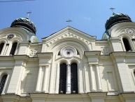
- ⊙ St. Dimitar Church (Simeon Veliki Street): This is the second biggest church in Bulgaria after St. Alexander Nevski in Sofia, and it is one of the oldest. The central dome is 33 meters high. Inside, there are beautiful murals depicting Biblical events, as well as the life of the town’s patron St. Dimitar. The priests are all friendly and the atmosphere is formal. On big holidays like Easter, Christmas, and New Year’s almost every inhabitant goes there to celebrate the big day. But it isn’t necessary to go there on holidays only. It is traditional to light a candle for the happiness of your family or friends, or to remember the dead.
- ⊙ Osman Pazvantoglu Mosque (9:00 - 16:00): This is the only mosque in the world to have a heart on top instead of a half moon. Osman Pazvantoglu made it to show his love to a Bulgarian woman. It was built from 1801-1802, but no longer serves a religious function. Also in the yard is a library supposedly built for his mother.
- ⊙ Synagogue: Smaller than the synagogue in Sofia, but supposedly more beautiful, this was built in 1894 with donations from citizens in the nearby neighborhood and Jews from all over the country. Since 1950, the building has been out of use. The yard is open, and you can explore the ruined building, especially if you want silence.
Museums
- ⊙ Konaka Historical Museum Vidin (9:00-18:00 M-F, 2-5 lv, 2 Obshtinska St, combined daily ticket with Baba Vida Fortress: 5lv) - : The Konaka Museum is in the center of Vidin. It is an 18th century building reconstructed after the liberation from the Ottomans, during which Bulgarian Renaissance architectural elements were introduced. It originally served as a police station. It is very well preserved and holds information about Vidin’s past. There are many exhibits from all ages, including Prehistoric, Antique, and the Middle Ages. The museum has an interesting architecture and views from upstairs windows, but is recommended to consult the web site before visiting because it's an old museum from 1960-1970 with information only in Bulgarian. Sometime you can find a lady at ticket booth that understand and barely speaks english, but mostly there's only a Bulgarian speaking, but friendly lady.
- ⊙ Krastata Kazarma (Cross-Shaped Barracks) (9:00-12:00, 14:00-17:00 M-Sat, 2-4 lv, 34 Knyaz Boris I): It was built in 1801 for the Ottomans. After Bulgaria’s liberation, it served as a law court and barracks for the Bulgarian army. Today it is an ethnographic museum with national costumes and Bulgarian crafts.
- ⊙ Nikola Petrov Gallery: Built in 1961, this gallery houses amazing works of art by famous Bulgarian painters and sculptors. It is situated in the Danube Park.
Information about copyright | |
|---|---|
Rights characteristic / license | by-sa: CREATIVE COMMONS Attribution-ShareAlike |
Link to the description of the license | |
Input taken over from: |
Wikivoyage contributors, 'Vidin', Wikivoyage, The FREE worldwide travel guide that anyone can edit, 10 May 2016, 02:05 UTC, <https://en.wikivoyage.org/w/index.php?title=Vidin&oldid=2993603> [accessed 2 October 2016] |
taken over / edited on | 02 Oct 2016
|
taken over / edited by |
|
89 km
0,2 km
352 m
Information about copyright | |
|---|---|
Rights owner | |
Rights characteristic / license | by-sa: CREATIVE COMMONS Attribution-ShareAlike |
Link to the description of the license | |
Image taken over from | https://commons.wikimedia.org/wiki/File:Magura_cave_hunting_scene_1519.jpg |
Image has been uploaded | by biroto-Redaktion on 31 Dec 2020
|
Information about copyright | |
|---|---|
Rights owner | |
Rights characteristic / license | by-sa: CREATIVE COMMONS Attribution-ShareAlike |
Link to the description of the license | |
Image taken over from | |
Image has been uploaded | by biroto-Redaktion on 31 Dec 2020
|
Information about copyright | |
|---|---|
Rights owner | |
Rights characteristic / license | by-sa: CREATIVE COMMONS Attribution-ShareAlike |
Link to the description of the license | |
Image taken over from | |
Image has been uploaded | by biroto-Redaktion on 31 Dec 2020
|
The Magura Cave (Bulgarian "пещера Магура") is located in north-western Bulgaria close to the village of Rabisha ![]() , 25 km (16 mi) from the town of Belogradchik
, 25 km (16 mi) from the town of Belogradchik ![]() in Vidin Province.
in Vidin Province.
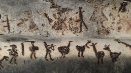
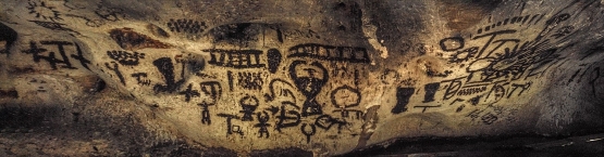
The prehistoric wall paintings of Magura have great resemblance with those of the Grotta dei Cervi in Italy, which are of exceptional expression and artistic depth and are considered the most significant works of art of the European Post-Paleolithic era.
Guided visits are conducted by the staff of Belogradchik municipality, to which the management of the cave was transferred in 2012 by the Bulgarian Council of Ministers.
In 1984 the site was induced into UNESCO's tentative list of World Heritage.
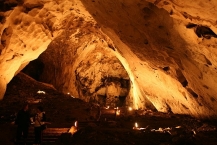
Description
The total length of the 15 million year old cave is 2.5 km (1.6 mi). The average annual temperature of the cave is 12 °C (54 °F; 285 K), except for one room where the temperature is always 15 °C (59 °F; 288 K). The air humidity reaches 80% and the displacement - 56 m (184 ft). The Magura cave was formed in the limestone Rabisha Hill (461 m (1,512 ft) above sea level). The morphology of the cave consists of one main gallery with six various-sized halls and three lateral galleries around it. The main gallery is composed of six chambers, variously sized; the largest one, the so-called Arc Hall, is 128 m (420 ft) long, 58 m (190 ft) wide and 21 m (69 ft) high, including impressive natural vaults, speleothems, spectacular stalactites and stalagmites, named The Poplar, The Pipe Organ, The Oriental City and The Cactus. The very spacious site also allows for music concerts to be held during Christmas and Easter.
Paintings
Cave paintings dating from the Epipaleolithic, late Neolithic, Eneolithic and early Bronze Age decorate some of the cave's walls. The paintings have been estimated to be made between 10.000 and 8.000 years ago. The drawings represent important events of the society that had occupied the Magura cave: religious ceremonies, hunting scenes and depictions of deities which are unique on the Balkan peninsula. The Fertility Dance and the Hunting Ceremony rank among the most noteworthy paintings.
Information about copyright | |
|---|---|
Rights characteristic / license | by-sa: CREATIVE COMMONS Attribution-ShareAlike |
Link to the description of the license | |
Input taken over from: |
Wikipedia contributors, 'Magura Cave', Wikipedia, The Free Encyclopedia, 10 August 2020, 21:29 UTC, <https://en.wikipedia.org/w/index.php?title=Magura_Cave&oldid=972218330> [accessed 31 December 2020] |
taken over / edited on | 31 Dec 2020
|
taken over / edited by |
|
Hours of opening
From 01 January to 31 March | From 01 April to 30 September | From 01 October to 1 January | |
Magura cave
| From Monday to Sunday every day 09.30 - 18.30 First entry for the day - 10.00 Last entry for the day - 16.30 | Every day every day 09.30 - 18.30 First entry for the day - 10.00 Last entry for the day - 16.30 | From Monday to Sunday every day 09.30 - 18.30 First entry for the day - 10.00 Last entry for the day - 16.00 |
112 km
0,1 km
517 m
Information about copyright | |
|---|---|
Rights owner | |
Rights characteristic / license | by-sa: CREATIVE COMMONS Attribution-ShareAlike |
Link to the description of the license | |
Image taken over from | https://commons.wikimedia.org/wiki/File:Belogradchik_Fortress_Entrance.jpg |
Image has been uploaded | by biroto-Redaktion on 31 Dec 2020
|
Information about copyright | |
|---|---|
Rights owner | |
Rights characteristic / license | by-sa: CREATIVE COMMONS Attribution-ShareAlike |
Link to the description of the license | |
Image taken over from | |
Image has been uploaded | by biroto-Redaktion on 31 Dec 2020
|
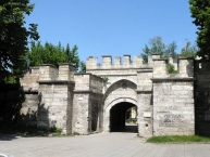
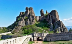
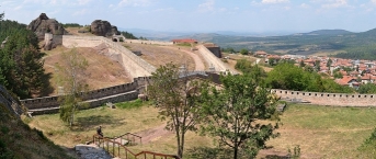
Belogradchik (Bulgarian: Белоградчик) is a city in North Bulgaria in the foothills of the Balkan Mountains. The town is famous throughout Bulgaria for its unique rock formations.
See
- Belogradchik Rocks, Bulgaria's most spectacular rock formations covering an area of 90 km². Some of the best views of the rocks are from the main square, the top of the fortress, the town park or along one of the many hiking trails. Belogradchik Rocks is a nominee for the New7Wonders of Nature [1]
- ⊙Belogradchik Fortress, built into the towering rocks on the hilltop overlooking the town. Open daily: Jun-Sep 08:00-21:00; Oct-May 09:00-17:00. The fortress, also called Kaleto, was begun by the Romans in the 1st-3rd centuries, continued by the Bulgarians and later completed by the Turks in the 19th century. From the top of the fortress, there are spectacular views of the surrounding hills and rock formations.
- There is an defunct Ottoman Mosque nearby to and easily visible from the fortress. It was supposedly built in 1751. It's not in the best repair these days and the building itself is not very remarkable, but the minaret and Arabic artwork above the door are beautiful. Worth taking a bit to admire.
- ⊙History Museum, in town center on the main street. M-F 09:00-12:00 & 14:00-17:00. A small museum containing exhibits of local history and folklore. The museum is housed in a well-preserved national revival period home (c.1810).
- ⊙Natural History Museum, in the town park. M-F 08:00-12:00 & 14:00-17:00. A small museum featuring wildlife native to the region.
Eat
- ⊙Tavern Madonna, ☎ +359 936 5546. It offers traditional Bulgarian cuisine and features many local and regional specialties.
- ⊙Restaurant Skalite, ☎ +359 94 691210. Standard Bulgarian fare.
Information about copyright | |
|---|---|
Rights characteristic / license | by-sa: CREATIVE COMMONS Attribution-ShareAlike |
Link to the description of the license | |
Input taken over from: |
Wikivoyage contributors, 'Belogradchik', Wikivoyage, The FREE worldwide travel guide that anyone can edit, 3 December 2020, 04:16 UTC, https://en.wikivoyage.org/w/index.php?title=Belogradchik&oldid=4100494 [accessed 30 December 2020] |
taken over / edited on | 30 Dec 2020
|
taken over / edited by |
|
166 km
0,2 km
391 m
Information about copyright | |
|---|---|
Rights owner | https://commons.wikimedia.org/w/index.php?title=User:Камен_Ха�% |
Rights characteristic / license | by-sa: CREATIVE COMMONS Attribution-ShareAlike |
Link to the description of the license | |
Image taken over from | https://commons.wikimedia.org/wiki/File:Област_Монтана_-_Община_Чипровци_-_Гр._Чипро%D |
Image has been uploaded | by biroto-Redaktion on 31 Dec 2020
|
Information about copyright | |
|---|---|
Rights owner | |
Rights characteristic / license | by-sa: CREATIVE COMMONS Attribution-ShareAlike |
Link to the description of the license | |
Image taken over from | https://commons.wikimedia.org/wiki/File:Chiprovtsi_Monastery.jpg |
Image has been uploaded | by biroto-Redaktion on 31 Dec 2020
|
Information about copyright | |
|---|---|
Rights owner | https://commons.wikimedia.org/w/index.php?title=User:Камен_Ха�% |
Rights characteristic / license | by-sa: CREATIVE COMMONS Attribution-ShareAlike |
Link to the description of the license | |
Image taken over from | https://commons.wikimedia.org/wiki/File:Област_Монтана_-_Община_Чипровци_-_Гр._Чипро%D |
Image has been uploaded | by biroto-Redaktion on 31 Dec 2020
|
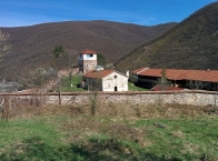
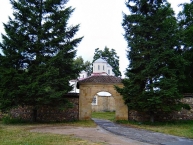
Chiprovtsi Monastery (Bulgarian: Чипровски манастир, Chiprovski manastir) is a Bulgarian Orthodox monastery 5 kilometres northeast of the town of Chiprovtsi ![]() in Montana Province in northwestern Bulgaria. It belongs to the diocese of Vidin and lies in the valley of the Ogosta river.
in Montana Province in northwestern Bulgaria. It belongs to the diocese of Vidin and lies in the valley of the Ogosta river.
According to Petar Bogdan, the monastery was built in the 10th century and remained a religious and cultural centre despite Tatar and Magyar raids in the 13th century, the Ottoman invasion in the 14th century and Michael the Brave's raids in the 16th century. The monastery has been razed six times, in 1412, 1688, 1806, 1828, 1837 and 1876, with the one of 1688 after the Chiprovtsi Uprising being particularly devastating. The current monastery church was built in 1829.
The Chiprovtsi Monastery consists of a church dedicated to Saint John of Rila, residential buildings, a small graveyard and a three-storey tower featuring an ossuary, a chapel and a belfry.
Information about copyright | |
|---|---|
Rights characteristic / license | by-sa: CREATIVE COMMONS Attribution-ShareAlike |
Link to the description of the license | |
Input taken over from: |
Wikipedia contributors, 'Chiprovtsi Monastery', Wikipedia, The Free Encyclopedia, 18 October 2015, 01:35 UTC, https://en.wikipedia.org/w/index.php?title=Chiprovtsi_Monastery&oldid=686257751 [accessed 31 December 2020] |
taken over / edited on | 31 Dec 2020
|
taken over / edited by |
|
196 km
0,2 km
263 m
Information about copyright | |
|---|---|
Rights owner | https://www.panoramio.com/user/1456750?with_photo_id=9647656 |
Rights characteristic / license | by-sa: CREATIVE COMMONS Attribution-ShareAlike |
Link to the description of the license | |
Image taken over from | https://commons.wikimedia.org/wiki/File:Lopushna-monastery-olegivanov-3.jpg |
Image has been uploaded | by biroto-Redaktion on 31 Dec 2020
|
Information about copyright | |
|---|---|
Rights owner | https://commons.wikimedia.org/w/index.php?title=User:Jonatand |
Rights characteristic / license | by-sa: CREATIVE COMMONS Attribution-ShareAlike |
Link to the description of the license | |
Image taken over from | https://commons.wikimedia.org/wiki/File:Дворът_на_манастир_"Св._Йоан_Предтеча".jpg |
Image has been uploaded | by biroto-Redaktion on 31 Dec 2020
|
Information about copyright | |
|---|---|
Rights owner | https://commons.wikimedia.org/w/index.php?title=User:Jonatand |
Rights characteristic / license | by-sa: CREATIVE COMMONS Attribution-ShareAlike |
Link to the description of the license | |
Image taken over from | https://commons.wikimedia.org/wiki/File:Църквата_на_манастир_"Св._Йоан_Предтеча".jpg |
Image has been uploaded | by biroto-Redaktion on 31 Dec 2020
|
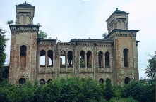
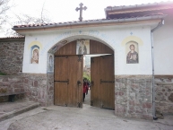
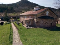
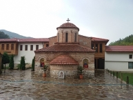
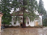
The Lopushna Monastery of Saint John the Forerunner (Bulgarian: Лопушански манастир „Свети Йоан Предтеча“, Lopushanski manastir „Sveti Yoan Predtecha“) is a Bulgarian Orthodox monastery in northwestern Bulgaria. It lies in the Chiprovtsi part of the western Balkan Mountains, 1.5 kilometres (0.93 mi) southwest the village of Georgi Damyanovo ![]() , Montana Province.
, Montana Province.
Founded in the Middle Ages but built in its present appearance throughout the 1850s, the Lopushna Monastery, and particularly its complex main church, are one of the most notable works of the Slavine Architectural School and its most prominent figure, Lilo Lazarov. It was in the construction of the monastery cathedral that Lazarov first employed vernacular Gothic decorative features, a trademark approach of the Slavine School that set it apart from other architectural schools of the Bulgarian National Revival.
Information about copyright | |
|---|---|
Rights characteristic / license | by-sa: CREATIVE COMMONS Attribution-ShareAlike |
Link to the description of the license | |
Input taken over from: |
Wikipedia contributors, 'Lopushna Monastery', Wikipedia, The Free Encyclopedia, 28 May 2020, 04:43 UTC, <https://en.wikipedia.org/w/index.php?title=Lopushna_Monastery&oldid=959313373> [accessed 31 December 2020] |
taken over / edited on | 31 Dec 2020
|
taken over / edited by |
|
![]()