
Cycle Route Nacionalna ruta 1
No. of cycle route 1
Actions
![]()
Please wait - map data are loading
Added on 22 Oct 2014,
last edited by biroto-Redaktion on 12 Jan 2021
Actions
Cycle route metrics
Total distance in km
735
Information about rights to the gps-track data | |
|---|---|
Rights owner | OpenStreetMap and Contributors + biroto-Redaktion (biroto.eu) |
Rights characteristic / license | Contains information from OpenStreetMap, which is made available here under the Open Database License(ODbL) |
Link to the description of the license | |
GPX file taken from | |
GPX file uploaded | by biroto-Redaktion on 12 Jan 2021
|
Track points in total
11.375
Track points per km (avg)
15
Start/endpoint
Start location
Zagreb, HR (114 m NHN)
End location
Gornji Kraj, HR (74 m NHN)
Beds4Cyclists, worth visiting and infrastructure
Name and address
Latitude / Longitude
Phone
Fax
Mobile
Type of accommodation
Rating for cyclists
Route km
Dist. to route
Elevation
0 km
3,1 km
120 m
Information about copyright | |
|---|---|
Rights owner | |
Rights characteristic / license | by-sa: CREATIVE COMMONS Attribution-ShareAlike |
Link to the description of the license | |
Image has been uploaded | by kugu on 08 Jun 2017
|
0 km
2,2 km
113 m
375 km
1,1 km
174 m
Information about copyright | |
|---|---|
Rights owner | |
Rights characteristic / license | by-sa: CREATIVE COMMONS Attribution-ShareAlike |
Link to the description of the license | |
Image taken over from | |
Image has been uploaded | by biroto-Redaktion on 12 Sep 2014
|
Information about copyright | |
|---|---|
Rights owner | |
Rights characteristic / license | by-sa: CREATIVE COMMONS Attribution-ShareAlike |
Link to the description of the license | |
Image taken over from | |
Image has been uploaded | by biroto-Redaktion on 12 Sep 2014
|
Information about copyright | |
|---|---|
Rights owner | Zoran Knez & Dražen Radujkov |
Rights characteristic / license | cc0: Public Domain no Rights reserved |
Link to the description of the license | |
Image taken over from | |
Image has been uploaded | by biroto-Redaktion on 12 Sep 2014
|
Krka National Park (Croatian ![]() : Nacionalni park Krka) is one of the Croatian
: Nacionalni park Krka) is one of the Croatian ![]() national parks
national parks ![]() , named after the river Krka
, named after the river Krka ![]() that it encloses. It is located along the middle-lower course of the Krka River
that it encloses. It is located along the middle-lower course of the Krka River ![]() in central Dalmatia
in central Dalmatia ![]() , in Šibenik-Knin county, downstream Miljevci
, in Šibenik-Knin county, downstream Miljevci ![]() area, and just a few kilometers northeast of the city of Šibenik
area, and just a few kilometers northeast of the city of Šibenik ![]() . It was formed to protect the Krka River and is intended primarily for scientific, cultural, educational, recreational, and tourism activities. It is the seventh national park
. It was formed to protect the Krka River and is intended primarily for scientific, cultural, educational, recreational, and tourism activities. It is the seventh national park ![]() in Croatia and was proclaimed a national park in 1985.
in Croatia and was proclaimed a national park in 1985.
When you are at the Krka National Park there are several places of interest. The attractions and facilities available are various footpaths, sightseeing tours and presentations, boat trips, souvenir shops, a museum, and restaurants. There are also several archeological remains of unpreserved fortresses in the park's vicinity dating back to as far as the Roman times. They are Čučevo, Nečven ![]() , Bogočin, Ključica and Burnum
, Bogočin, Ključica and Burnum ![]() .
.
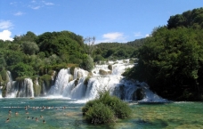
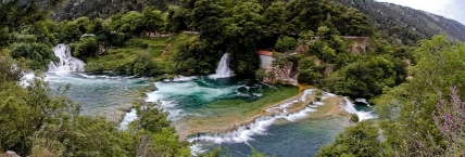
Skradinski buk
Skradinski buk is one of the most attractive parts of the park. It is a massive, clear, natural pool with high waterfalls at one end and cascades at the other, located in the Krka National Park in Croatia. It is the lowest of the three sets of waterfalls formed along the Krka ![]() river. In an area 400 m in length and 100 m in width there are 17 waterfalls and the total difference in height between the first and the last falls is 47.7 m. Due to the wealth and variety of geomorphological forms, vegetation, and the various effects caused by the play of light on the whirlpools, Skradinski buk is considered to be one of the most beautiful calcium carbonate waterfalls in Europe.
river. In an area 400 m in length and 100 m in width there are 17 waterfalls and the total difference in height between the first and the last falls is 47.7 m. Due to the wealth and variety of geomorphological forms, vegetation, and the various effects caused by the play of light on the whirlpools, Skradinski buk is considered to be one of the most beautiful calcium carbonate waterfalls in Europe.
The rate of flow is 43 m3 a second in winter, 18 m3 in summer, with an average of 55 cubic metres a second flowing down Skradinski buk annually. It is the largest travertine cascade system in Europe.
Roški Slap
Roški Slap, located near Miljevci ![]() , is the second most popular attraction of the Krka National Park in terms of numbers of visitors. These cascades can be visited throughout the year. The most attractive way to reach Roški Slap is to take one of the excursion boats operated by the Krka National Park, although the falls can also be reached with a public road.
, is the second most popular attraction of the Krka National Park in terms of numbers of visitors. These cascades can be visited throughout the year. The most attractive way to reach Roški Slap is to take one of the excursion boats operated by the Krka National Park, although the falls can also be reached with a public road.
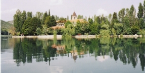
Visovac
Inside the park is the island of Visovac which was founded during the reign of Louis I of Hungary, home to the Roman Catholic Visovac Monastery ![]() founded by the Franciscans in 1445 near Miljevci
founded by the Franciscans in 1445 near Miljevci ![]() village. The park also includes the Eastern Orthodox
village. The park also includes the Eastern Orthodox ![]() Monastery Krka
Monastery Krka ![]() founded in 1345. The island can be visited by a boat tour from Skradinski buk.
founded in 1345. The island can be visited by a boat tour from Skradinski buk.
The Krka monastery is a spiritual center of the Orthodox Dalmatian Eparchy (Diocese), which has its see in Šibenik. It was first mentioned in written documents in the year 1402 as the pious endowment of Jelena Šubić, the sister of Emperor Dušan. The monastery was built and rebuilt until the late 18th century.
Information about copyright | |
|---|---|
Rights characteristic / license | by-sa: CREATIVE COMMONS Attribution-ShareAlike |
Link to the description of the license | |
Input taken over from: |
Wikipedia contributors, 'Krka National Park', Wikipedia, The Free Encyclopedia, 11 August 2014, 01:17 UTC, <http://en.wikipedia.org/w/index.php?title=Krka_National_Park&oldid=620708551> [accessed 11 September 2014] |
taken over / edited on | 12 Sep 2014
|
taken over / edited by |
|
Hours of opening
From 8:00 am to 8:00 pm
385 km
2,1 km
27 m
Information about copyright | |
|---|---|
Rights owner | Jerzy Strzelecki |
Rights characteristic / license | by-sa: CREATIVE COMMONS Attribution-ShareAlike |
Link to the description of the license | |
Image taken over from | |
Image has been uploaded | by biroto-Redaktion on 11 Sep 2014
|
Information about copyright | |
|---|---|
Rights owner | |
Rights characteristic / license | by-sa: CREATIVE COMMONS Attribution-ShareAlike |
Link to the description of the license | |
Image taken over from | commons.wikimedia.org/wiki/File:St._Jacobuskathedraal_;_Sibenik.jpg |
Image has been uploaded | by biroto-Redaktion on 11 Sep 2014
|
Information about copyright | |
|---|---|
Rights owner | |
Rights characteristic / license | by-sa: CREATIVE COMMONS Attribution-ShareAlike |
Link to the description of the license | |
Image taken over from | commons.wikimedia.org/wiki/File:St_Jacobs_Cathedral_inside.JPG |
Image has been uploaded | by biroto-Redaktion on 11 Sep 2014
|
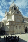
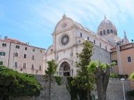
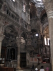
The Cathedral of St. James (Croatian: Katedrala sv. Jakova) in Šibenik ![]() , Croatia is a triple-nave basilica with three apses and a dome (32 m high inside) in the city of Šibenik, Croatia. It is the church of the Catholic Church in Croatia, and the see of the Šibenik diocese. It is also the most important architectural monument of the Renaissance in the entire country. Since 2000, the Cathedral has been on the UNESCO World Heritage List.
, Croatia is a triple-nave basilica with three apses and a dome (32 m high inside) in the city of Šibenik, Croatia. It is the church of the Catholic Church in Croatia, and the see of the Šibenik diocese. It is also the most important architectural monument of the Renaissance in the entire country. Since 2000, the Cathedral has been on the UNESCO World Heritage List.
Information about copyright | |
|---|---|
Rights characteristic / license | by-sa: CREATIVE COMMONS Attribution-ShareAlike |
Link to the description of the license | |
Input taken over from: |
Wikipedia contributors, 'Šibenik Cathedral', Wikipedia, The Free Encyclopedia, 30 May 2014, 09:14 UTC, <http://en.wikipedia.org/w/index.php?title=%C5%A0ibenik_Cathedral&oldid=610765085> [accessed 11 September 2014] |
taken over / edited on | 11 Sep 2014
|
taken over / edited by |
|
434 km
2,7 km
3 m
Information about copyright | |
|---|---|
Rights owner | |
Rights characteristic / license | by-sa: CREATIVE COMMONS Attribution-ShareAlike |
Link to the description of the license | |
Image taken over from | |
Image has been uploaded | by biroto-Redaktion on 11 Sep 2014
|
Information about copyright | |
|---|---|
Rights owner | |
Rights characteristic / license | by-sa: CREATIVE COMMONS Attribution-ShareAlike |
Link to the description of the license | |
Image taken over from | |
Image has been uploaded | by biroto-Redaktion on 11 Sep 2014
|
Information about copyright | |
|---|---|
Rights owner | |
Rights characteristic / license | cc0: Public Domain no Rights reserved |
Link to the description of the license | |
Image taken over from | commons.wikimedia.org/wiki/File:Cathedral_St._Lawrence-Trogir-7.jpg |
Image has been uploaded | by biroto-Redaktion on 11 Sep 2014
|
Information about copyright | |
|---|---|
Rights owner | |
Rights characteristic / license | by-sa: CREATIVE COMMONS Attribution-ShareAlike |
Link to the description of the license | |
Image taken over from | commons.wikimedia.org/wiki/File:Trogir_kula_Kamerlengo_064.jpg |
Image has been uploaded | by biroto-Redaktion on 11 Sep 2014
|
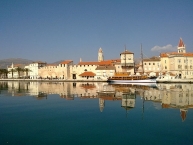
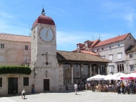
Trogir (or Traù) is a historic town and harbour on the Adriatic coast in Split-Dalmatia County, Croatia, with a population of 10,818 (2011) and a total municipality population of 13,260 (2011). The historic city of Trogir is situated on a small island between the Croatian mainland and the island of Čiovo ![]() . It lies 27 kilometres (17 miles) west of the city of Split
. It lies 27 kilometres (17 miles) west of the city of Split ![]() .
.
Since 1997, the historic centre of Trogir has been included in the UNESCO list of World Heritage Sites.
Main sights
Trogir has 2300 years of continuous urban tradition. Its culture was created under the influence of the ancient Greeks, and then the Romans, and Venetians. Trogir has a high concentration of palaces, churches, and towers, as well as a fortress on a small island, and in 1997 was inscribed in the UNESCO World Heritage List. "The orthogonal street plan of this island settlement dates back to the Hellenistic period and it was embellished by successive rulers with many fine public and domestic buildings and fortifications. Its beautiful Romanesque churches are complemented by the outstanding Renaissance and Baroquebuildings from the Venetian period", says the UNESCO report.
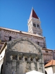
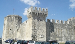
Trogir is the best-preserved Romanesque-Gothic complex not only in the Adriatic, but in all of Central Europe. Trogir's medieval core, surrounded by walls, comprises a preserved castle and tower and a series of dwellings and palaces from the Romanesque, Gothic, Renaissance and Baroque periods. Trogir's grandest building is the church of St. Lawrence ![]() , whose main west portal is a masterpiece by Radovan, and the most significant work of the Romanesque-Gothic style in Croatia.
, whose main west portal is a masterpiece by Radovan, and the most significant work of the Romanesque-Gothic style in Croatia.
The most important sites include:
- Historical city core, with about 10 churches and numerous buildings from 13th century
- The city gate (17th century) and city walls (15th century)
- The Fortress Kamerlengo
 (15th century)
 - The Duke's Palace (13th century)
- The Cathedral (13th century) with the Portal of Master Radovan, the unique work of this Croatian artist
- The big and small palaces Cipiko from the 15th century
- The city loggia from 15th century
Information about copyright | |
|---|---|
Rights characteristic / license | by-sa: CREATIVE COMMONS Attribution-ShareAlike |
Link to the description of the license | |
Input taken over from: |
Wikipedia contributors, 'Trogir', Wikipedia, The Free Encyclopedia, 6 September 2014, 10:03 UTC, <http://en.wikipedia.org/w/index.php?title=Trogir&oldid=624398143> [accessed 11 September 2014] |
taken over / edited on | 11 Sep 2014
|
taken over / edited by |
|
![]()