
Cycle Route Hodonín-Olmútz
No. of cycle route 4
Actions
![]()
Please wait - map data are loading
Added on 16 Dec 2012,
last edited by biroto-Redaktion on 28 Oct 2023
Actions
Cycle route metrics
Total distance in km
315
Information about rights to the gps-track data | |
|---|---|
Rights owner | OpenStreetMap and Contributors + biroto-Redaktion (biroto.eu) |
Rights characteristic / license | Contains information from OpenStreetMap, which is made available here under the Open Database License(ODbL) |
Link to the description of the license | |
GPX file taken from | |
GPX file uploaded | by biroto-Redaktion on 28 Oct 2023
|
Track points in total
5.068
Track points per km (avg)
16
Start/endpoint
Start location
Břeclav, JM, CZ (162 m NHN)
End location
Mikulovice, OL, CZ (309 m NHN)
Signposting
|
|

Beds4Cyclists, worth visiting and infrastructure
Name and address
Latitude / Longitude
Phone
Fax
Mobile
Type of accommodation
Rating for cyclists
Route km
Dist. to route
Elevation
0 km
4,5 km
154 m
0 km
1,4 km
159 m
0 km
0,3 km
174 m
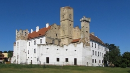
Information about copyright | |
|---|---|
Rights owner | |
Rights characteristic / license | by-sa: CREATIVE COMMONS Attribution-ShareAlike |
Link to the description of the license | |
Image taken over from | https://commons.wikimedia.org/wiki/File:Breclav_zamek_001.jpg |
Image has been uploaded | by biroto-Redaktion on 10 Oct 2019
|
Břeclav (deutsch: Lundenburg) ist eine Stadt und wichtiger Bahnknoten in der Region Südmähren, am Dreiländereck Tschechien-Österreich-Slowakei unweit der Mündung der Thaya in die March.
Sehenswürdigkeiten
- Schloss. Aus dem 16. Jahrhundert, im 19. Jahrhundert zu einer künstlichen Ruine im neugotischen Stil umgebaut.
- Pfarrkirche Poštorná. (1895–1898).
- Wenzelskirche. Moderne Kirche (1992–1995).
- Synagoge. Neuromanischer Stil, Architekt Max Fleischer, seit dem 2. Weltkrieg ohne religiöse Nutzung. Heute befinden sich in dem Gebäude das Stadtmuseum und die Kunstgalerie.
- Jüdischer Friedhof. u.a. Grabmal der Familie Kuffner, 1899).
- Gymnasium.
- Apollo-Tempel
 . Pavillon mit Aussichtsterrasse - Architekt Joseph Kornhäusel (1817–1819) - an der westlichen Gemeindegrenze auf dem Hügel des Mühlteiches (Mlýnský rybník, auch Apollo-Teich). Nachgebauter altgriechischer Tempel und Teil des Unesco-Welterbekomplexes Kulturlandschaft Lednice-Valtice
  .
. - Bahnhof. Das Aufnahmegebäude versprüht immer noch den Charme der KuK-Nordbahn um 1900.
Information about copyright | |
|---|---|
Rights characteristic / license | by-sa: CREATIVE COMMONS Attribution-ShareAlike |
Link to the description of the license | |
Input taken over from: |
Wikivoyage-Bearbeiter, 'Břeclav', Wikivoyage, Freie Reiseinformationen rund um die Welt, 20. Februar 2019, 20:04 UTC, https://de.wikivoyage.org/w/index.php?title=B%C5%99eclav&oldid=1178576 [abgerufen am 10. Oktober 2019] |
taken over / edited on | 10 Oct 2019
|
taken over / edited by |
|
5 km
0,1 km
157 m
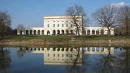
Information about copyright | |
|---|---|
Rights owner | |
Rights characteristic / license | by-sa: CREATIVE COMMONS Attribution-ShareAlike |
Link to the description of the license | |
Image taken over from | https://commons.wikimedia.org/wiki/File:Zamek_Pohansko_05.jpg |
Image has been uploaded | by biroto-Redaktion on 11 Oct 2019
|
Pohansko ist ein Reichsjagdschloss im Gebiet Lednice-Valtice, etwa 3,5 km südöstlich des Zentrums von Břeclav ![]() .
.
Das Schloss Pohansko wurde 1811 - 1812 von Fürst Johann I. von Liechtenstein erbaut. Der Entwurf stammt von Josef Hardtmuth und Josef Kornhäusel.
Derzeit ist das Schloss Eigentum der Stadt Břeclav. In seinen Räumen befindet sich seit 1998 eine archäologische Ausstellung des Stadtmuseums Břeclav. Es werden Funde aus Ausgrabungen der gleichnamigen slawischen Wehrsiedlung nordöstlich der Burg präsentiert.
Das Herrenhaus Pohansko hat einen rechteckiger Grundriss. Säulenarkaden ziehen sich durch das gesamte Erdgeschoss. In der nordöstlichen Fassade des ersten Stocks befindet sich eine Loggia mit zwölf ionischen Säulen. Die Fassade ist mit runden Medaillons und rechteckigen Reliefs mit Jagdszenen verziert. Der Künstler war wahrscheinlich der Wiener Bildhauer Josef Klieber.
Information about copyright | |
|---|---|
Rights characteristic / license | by-sa: CREATIVE COMMONS Attribution-ShareAlike |
Link to the description of the license | |
taken over / edited on | 11 Oct 2019
|
taken over / edited by |
|
38 km
4,7 km
181 m
![]()