
Cycle Route Všeruby-Cheb
No. of cycle route 36
Actions
![]()
Please wait - map data are loading
Added on 12 Apr 2012,
last edited by biroto-Redaktion on 25 Oct 2023
Actions
Cycle route metrics
Total distance in km
158
Information about rights to the gps-track data | |
|---|---|
Rights owner | OpenStreetMap and Contributors + biroto-Redaktion (biroto.eu) |
Rights characteristic / license | Contains information from OpenStreetMap, which is made available here under the Open Database License(ODbL) |
Link to the description of the license | |
GPX file taken from | |
GPX file uploaded | by biroto-Redaktion on 25 Oct 2023
|
Track points in total
2.520
Track points per km (avg)
16
Start/endpoint
Start location
Všeruby, PL, CZ (447 m NHN)
End location
Cheb, KA, CZ (448 m NHN)
Signposting
|
|

Beds4Cyclists, worth visiting and infrastructure
Name and address
Latitude / Longitude
Phone
Fax
Mobile
Type of accommodation
Rating for cyclists
Route km
Dist. to route
Elevation
0 km
4,3 km
489 m
7 km
3,4 km
561 m
49 km
0,0 km
528 m
133 km
3,7 km
573 m
Information about copyright | |
|---|---|
Rights owner | |
Rights characteristic / license | cc0: Public Domain no Rights reserved |
Link to the description of the license | |
Image taken over from | |
Image has been uploaded | by biroto-Redaktion on 04 Aug 2014
|
Information about copyright | |
|---|---|
Rights owner | |
Rights characteristic / license | by-sa: CREATIVE COMMONS Attribution-ShareAlike |
Link to the description of the license | |
Image taken over from | |
Image has been uploaded | by biroto-Redaktion on 04 Aug 2014
|
Information about copyright | |
|---|---|
Rights owner | |
Rights characteristic / license | by-sa: CREATIVE COMMONS Attribution-ShareAlike |
Link to the description of the license | |
Image taken over from | commons.wikimedia.org/wiki/File:Kynžvart_Chateau_in_summer_2012_(5).JPG |
Image has been uploaded | by biroto-Redaktion on 04 Aug 2014
|
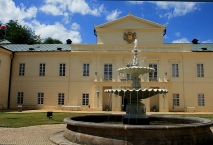
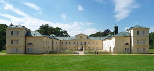
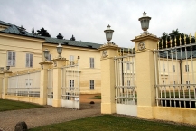
Kynžvart Castle (German: Schloss Königswart) is located in the District of Cheb in the Czech Republic and is built in neoclassical archytectural style. After extensive renovations, the castle was reopened to the public in 2000. The guided tour takes visitors through 25 rooms of the castle.
The first castle, built in 1623, collapsed. After the Battle of White Mountain during the Thirty Years' War remains of the castle were confiscated and later in 1630 granted to the Metternich family. From 1682 to 1691, Count Philipp Emmerich turned the decayed ruins into a Baroque castle; from 1821 to 1836, the Austrian Chancellor Klemens Wenzel von Metternich remodeled it in the imperial style with the help of architect Pietro Nobile.
The castle was confiscated from his family in 1945 by the Czechoslovak government.
The castle has a library that includes over 200 examples of incunabula), medieval manuscripts, valuable prints, scientific books, and scientific encyclopedias. In 1828 a museum was founded to display the castle's natural science collections, coins, historical and technological curiosities, manuscripts, ancient Egyptian monuments, marble sculptures, and pieces of Oriental art.
Information about copyright | |
|---|---|
Rights characteristic / license | by-sa: CREATIVE COMMONS Attribution-ShareAlike |
Link to the description of the license | |
Input taken over from: |
Wikipedia contributors, 'Kynžvart Castle', Wikipedia, The Free Encyclopedia, 17 April 2014, 16:24 UTC, <http://en.wikipedia.org/w/index.php?title=Kyn%C5%BEvart_Castle&oldid=604612291> [accessed 4 August 2014] |
taken over / edited on | 04 Aug 2014
|
taken over / edited by |
|
Hours of opening
| Januar | geschlossen | |
| Februar, März | nur mit bestätigter Reservierung; Bedingungen | |
| April | samstags und sonntags | 9.00 - 12.00, 12.30 - 16.00 |
| Mai, Juni | dienstags bis sonntags | 9.00 - 12.00, 12.30 - 16.00 |
| Juli, August | täglich ausser montags | 9.00 - 12.00, 13.00 - 17.00 |
| September | dienstags bis sonntags | 9.00 - 12.00, 12.30 - 16.00 |
| Oktober | samstags und sonntags | 9.00 - 12.00, 12.30 - 16.00 |
| November | nur mit bestätigter Vorbestellung; Bedingungen - siehe 1) | |
| Dezember | bis 27.12. - geschlossen | |
| Dezember | von 28. 12. bis zum 31. 12; | |
Mittagspause: | vom 12:00 bis 12:30 Uhr, Juni-August bis 13.00 Uhr |
Ruhetag: | Montag |
157 km
0,8 km
Hours of opening
Monday till Friday from 9.00 till 17.00 o´clock.
Saturday and Sunday from 9.00 till 12.30 o´clock.
Languages spoken:
čeština ▪ Deutsch
![]()