
Cycle Route Zhoř u Tábora-Slavonice
No. of cycle route 32
Actions
![]()
Please wait - map data are loading
Added on 16 Dec 2012,
last edited by biroto-Redaktion on 16 Oct 2023
Actions
Cycle route metrics
Total distance in km
89
Information about rights to the gps-track data | |
|---|---|
Rights owner | OpenStreetMap and Contributors + biroto-Redaktion (biroto.eu) |
Rights characteristic / license | Contains information from OpenStreetMap, which is made available here under the Open Database License(ODbL) |
Link to the description of the license | |
GPX file taken from | |
GPX file uploaded | by biroto-Redaktion on 16 Oct 2023
|
Track points in total
1.389
Track points per km (avg)
16
Start/endpoint
Start location
Lom, JC, CZ (466 m NHN)
End location
Slavonice, JC, CZ (519 m NHN)
Signposting
|
|

Beds4Cyclists, worth visiting and infrastructure
Name and address
Latitude / Longitude
Phone
Fax
Mobile
Type of accommodation
Rating for cyclists
Route km
Dist. to route
Elevation
6 km
2,3 km
408 m
6 km
2,4 km
421 m
23 km
0,0 km
467 m
Information about copyright | |
|---|---|
Rights owner | |
Rights characteristic / license | by-sa: CREATIVE COMMONS Attribution-ShareAlike |
Link to the description of the license | |
Image taken over from | |
Image has been uploaded | by biroto-Redaktion on 22 Dec 2012
|
Information about copyright | |
|---|---|
Rights owner | |
Rights characteristic / license | by-sa: CREATIVE COMMONS Attribution-ShareAlike |
Link to the description of the license | |
Image taken over from | |
Image has been uploaded | by biroto-Redaktion on 22 Dec 2012
|
Information about copyright | |
|---|---|
Rights owner | |
Rights characteristic / license | by-sa: CREATIVE COMMONS Attribution-ShareAlike |
Link to the description of the license | |
Image taken over from | |
Image has been uploaded | by biroto-Redaktion on 22 Dec 2012
|
Information about copyright | |
|---|---|
Rights owner | |
Rights characteristic / license | by-sa: CREATIVE COMMONS Attribution-ShareAlike |
Link to the description of the license | |
Image taken over from | |
Image has been uploaded | by biroto-Redaktion on 22 Dec 2012
|
Dírná (deutsch Dirna) ist eine Gemeinde in der Tschechischen Republik, und befindet sich 10 Kilometer östlich der Stadt Soběslav ![]() .
.
Erstmals urkundlich erwähnt wurde das Dorf 1340, als sich dort die Festung der Ritter von Dírná befand. Ab 1357 befand sich der Ort im Besitz der Herren Ruth von Dírná. 1597 erwarb Wilhelm Ruth das Schloss Nová Lhota ![]() das er zum Zentrum seiner Herrschaft machte. Barbara Ruth verkaufte Dírná 1607 an Adam Wratislaw von Mitrowitz
das er zum Zentrum seiner Herrschaft machte. Barbara Ruth verkaufte Dírná 1607 an Adam Wratislaw von Mitrowitz ![]() . Die ursprüngliche Festung verschwand. Im 18. Jahrhundert errichteten die Wratislaw die barocke Villa in Dírná, die durch den in den Felsen gemeißelten Burggraben verstärkt wurde. Eine Brauerei, eine Brennerei und der englische Park befanden sich auch in der Nähe.
. Die ursprüngliche Festung verschwand. Im 18. Jahrhundert errichteten die Wratislaw die barocke Villa in Dírná, die durch den in den Felsen gemeißelten Burggraben verstärkt wurde. Eine Brauerei, eine Brennerei und der englische Park befanden sich auch in der Nähe.
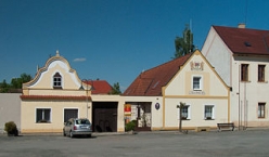
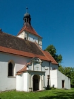
Auf einem kleinen Platz im Dorf befinden sich das Rathaus mit dem barocken Giebel, die gotische St. Laurentiuskirche aus dem 14. Jahrhundert und der barocke Getreidespeicher aus dem 18. Jahrhundert.
Information about copyright | |
|---|---|
Rights characteristic / license | by-sa: CREATIVE COMMONS Attribution-ShareAlike |
Link to the description of the license | |
Input taken over from: |
Seite „Dírná“. In: Wikipedia, Die freie Enzyklopädie. Bearbeitungsstand: 16. Dezember 2012, 19:08 UTC. URL: http://de.wikipedia.org/w/index.php?title=D%C3%ADrn%C3%A1&oldid=111748807 (Abgerufen: 22. Dezember 2012, 13:40 UTC) |
taken over / edited on | 22 Dec 2012
|
taken over / edited by |
|
27 km
0,1 km
485 m
Information about copyright | |
|---|---|
Rights owner | |
Rights characteristic / license | by-sa: CREATIVE COMMONS Attribution-ShareAlike |
Link to the description of the license | |
Image taken over from | |
Image has been uploaded | by biroto-Redaktion on 22 Dec 2012
|
Information about copyright | |
|---|---|
Rights owner | |
Rights characteristic / license | by-sa: CREATIVE COMMONS Attribution-ShareAlike |
Link to the description of the license | |
Image taken over from | commons.wikimedia.org/wiki/File:057_Zámek_červená_Lhota.Okres_JIndřichův_Hradec.Česko..jpg |
Image has been uploaded | by biroto-Redaktion on 22 Dec 2012
|
Information about copyright | |
|---|---|
Rights owner | |
Rights characteristic / license | by-sa: CREATIVE COMMONS Attribution-ShareAlike |
Link to the description of the license | |
Image taken over from | |
Image has been uploaded | by biroto-Redaktion on 22 Dec 2012
|
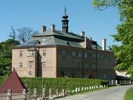
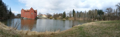
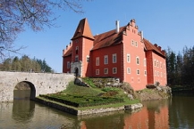
Červená Lhota is a château situated about 20 km north-west of Jindřichův Hradec ![]() in south Bohemia, Czech Republic. It stands at the middle of a lake on a rocky island. Its picturesque Renaissance building is a destination of thousands of tourists every year. Its name Červená Lhota meaning "red village" can be explained by the colour of the château's bright-red roof tiles. There is also a park, where the Chapel of Holly Trinity (Czech: Nejsvětější Trojice) is located.
in south Bohemia, Czech Republic. It stands at the middle of a lake on a rocky island. Its picturesque Renaissance building is a destination of thousands of tourists every year. Its name Červená Lhota meaning "red village" can be explained by the colour of the château's bright-red roof tiles. There is also a park, where the Chapel of Holly Trinity (Czech: Nejsvětější Trojice) is located.
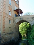
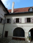
The four-winged two-storey château, with a small coutyard in the center, occupies the whole rock and juts into the fishpond. A stone bridge, built in 1622, links the château with the banks of the pond, replacing the original drawbridge. The interiors have an extensive collection of historic furniture, tiled stoves, pictures, porcelain and other items. The southern edge of the fishpond is covered in thick forest, which forms a backdrop to the château. On the northern side is a landscaped park where the Renaissance Chapel of the Holy Trinity is situated. A marked circular path tretches around the fishpond. Rowing across the fishpond is a pleasant diversion on a hot summer day, and boats can be hired near the château.
Information about copyright | |
|---|---|
Rights characteristic / license | by-sa: CREATIVE COMMONS Attribution-ShareAlike |
Link to the description of the license | |
Input taken over from: |
Wikipedia contributors, 'Červená Lhota Castle', Wikipedia, The Free Encyclopedia, 25 July 2012, 14:20 UTC, http://en.wikipedia.org/w/index.php?title=%C4%8Cerven%C3%A1_Lhota_Castle&oldid=504117026 [accessed 22 December 2012] |
taken over / edited on | 22 Dec 2012
|
taken over / edited by |
|
33 km
0,6 km
573 m
![]()