
Cycle Route Routes of the Forests and Lakes
No. of cycle route EE3
Actions
![]()
Please wait - map data are loading
Added on 05 Jun 2011,
on 12 Feb 2024
Actions
Cycle route metrics
Total distance in km
403
Information about rights to the gps-track data | |
|---|---|
Rights owner | OpenStreetMap and Contributors + biroto-Redaktion (biroto.eu) |
Rights characteristic / license | Contains information from OpenStreetMap, which is made available here under the Open Database License(ODbL) |
Link to the description of the license | |
GPX file taken from | |
GPX file uploaded | by biroto-Redaktion on 12 Feb 2024
|
Track points in total
3.742
Track points per km (avg)
9
Start/endpoint
Start location
Valga city, EE (50 m NHN)
End location
Narva linn, EE (30 m NHN)
Character
A segment of this cycling route, that between Valga and Tartu, is part of EuroVelo Route No. 11 extending from Athens to the North Cape. The more eye-catching areas are Karula National Park in the vicinity of Lüllemäe; Otepää Highlands, the main tourist magnet in South Estonia; and the summer vacationers’ town Elva. There are two gravel road sections between Lüllemäe and Otepää, totalling 17 km. It is worthwhile to take a longer stop in the region of Otepää to bike on the numerous routes (No. 261 – 265, currently not furnished with signposts). If you prefer gravel and forest paths to asphalt roads you can cycle from Otepää to Elva along the Tartu Bicycle Marathon track (Route 266, length 62 km).
The university city of Tartu also deserves a longer stay for sightseeing. Next we make for Lake Peipsi. A diversion to the lakeshore villages of Varnja and Kolkja involves 11 km of gravel roads, yet the peculiar milieu of these Russian Old Orthodox villagers makes it a memorable interlude. Scenes of village life can also be caught at the approach to Mustvee. After Mustvee the route turns away from the lake. The remaining distance to Rannapungerja offers pleasurable roads with little traffic, including 7 km of gravel cover.
Turning towards Peipsi again, we enter the cutest coastal areas of the lake. On beautiful summer days we can enjoy the pleasures of the beach and tender nights by the lakeside.
Next we pass through Iisaku; absolutely advisable is a diversion to Kuremäe Convent before we reach the landscape conservation area of Kurtna. The region is highly attractive yet the roads have suffered from poor maintenance at the hands of the local roadmasters. Here and there, noisy party-throwers may prove an annoyance.
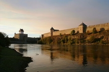
Jõhvi has little to offer as a town; after reaching the northern coast the route coincides with Route 1 until Narva. The places of interest on this stretch are the park of Toila-Oru, the high limestone bluff, the Stalinist-style industrial town of Sillamäe, the former holiday resort Narva-Jõesuu and the border city of Narva.
Slightly uncomfortable for the cyclist is an approximately 5-km stretch of gravel and dirt roads from Voka to the Tallinn-Narva highway; as well, the highway has to be used for three shorter stretches.
Information about copyright | |
|---|---|
Rights characteristic / license | © all rights reserved. |
Input taken over from: |
Copied from Esto Velo, permission received from Rein Lepik on 13 Oct. 2013. |
taken over / edited on | 13 Oct 2013 - 12 Feb 2024
|
taken over / edited by |
|
Signposting
|

Beds4Cyclists, worth visiting and infrastructure
Name and address
Latitude / Longitude
Phone
Fax
Mobile
Type of accommodation
Rating for cyclists
Route km
Dist. to route
Elevation
127 km
0,1 km
38 m
Tartu (formerly known as Dorpat or Yuryev) is the second largest city in Estonia with a population of 100,000.
Understand
Tartu is a Hanseatic city and a university town. It is the oldest city in Estonia, dating back to 1030. Its ancient name of 'Tarbatu' was shortened to 'Tartu' in Estonian and to 'Dorpat' in German. Although large parts of the town were destroyed in WWII, Tartu still has a charming old town surrounded by large parks (some of which used to be fully built-up neighbourhoods before the war).
The Emajõgi River, which connects the two largest lakes of Estonia, flows for 10 km within the city limits.
See
- ⊙Main building of the University of Tartu.
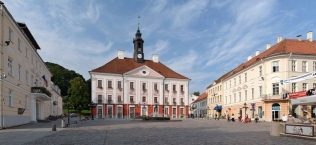
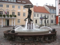
- ⊙Town Hall Square (Raekoja plats). The kissing students fountain is a symbol of Tartu.
- ⊙Statue of Oscar Wilde and Eduard Vilde (Kirjanike Oscar Wilde ja Eduard Vilde mälestusmärk).
- ⊙Soup Neighbourhood (Supilinn). Neighbourhood where all of the streets are named after soup ingredients. Features charming old wooden houses.
Museums
- ⊙Estonian National Museum (ERM), Muuseumi tee 2. 10AM to 6PM, closed on Mondays. The new building of the Estonian National Museum (Eesti Rahvamuuseum, ERM) is located north of the city centre near the Raadi mansion. It features a permanent exhibition on Estonian and Finno-Ugric culture, language, and traditions as well as various temporary installations. The museum can be easily reached from the city center on foot by following the newly constructed walkway along Roosi street (ca. 2 km total distance). €14. (updated Jun 2018)
- ⊙KGB Museum, Riia 15b, ☎ +372 746 1717. This nondescript building was known as the Gray House and was the headquarters of the Estonian KGB. It tells the story of how the prisoners were treated there, and some stories about the Estonian resistance heroes, the Forest Brothers. The museum is small and does not have a very big sign, so look carefully.
- ⊙Tartu Art Museum, Raekoja plats 18. W, F–Su 11–18:00 / Th 11–21:00.
 (updated Jan 2017)
 - ⊙Tartu City Museum, Narva 23. Classicist style structure was built as a town palace in 1790. The building is popularly called Catherine's House. The legend has it that Empress Catherine II made a short stay there. It is not true, though. The permanent exhibition provides a good insight into Tartu's long history up to 1920.
- ⊙Estonian Sports and Olympic Museum, Rüütli 15. M-Su 11-19. The Baltics biggest museum designated to sports, with several interactive exhibits. Please note that the winter sports exhibition is at another site, in Otepää town, which is about 45km from Tartu. 6 Euro, concession 5 Euro, family 15 Euro. (updated Oct 2018)
Parks and squares
- ⊙Botanic Garden of the University of Tartu, 38/40 Lai.
- ⊙Toome Hill. Many monuments, statues and historical buildings
- ⊙Raadi Park (Located on cross of the streets Vahi and Narva maantee).
- ⊙Barclay Park.
Churches
- ⊙St. John's Church (Tartu Jaani Church). 14th century church is famous for its thousands of medieval terracotta figures.
- ⊙Cathedral ruins (on top of the Dome Hill). From the 13th century and were dedicated to apostles St. Peter and Paul. Today the choir part houses the Tartu University History Museum, and the towers are reconstructed to sightseeing platforms.
- ⊙St. Paul's Church, Riia. An outstanding redbrick Finnish National Romanticist style building by the famous Finnish architect Eliel Saarinen.
- ⊙St. Peter's Church, 104 Narva St. A Neogothic Lutheran church from 1903, is built on the grounds of the first general Estonian song festival which took place in 1869.
- ⊙Roman Catholic Church, 1 Veski St. A beautiful neo-Historical redbrick building from 1899.
- ⊙St. Alexander's Orthodox Church, 19a Sõbra St. A two-story church, designed by architect V. Lunski, with cupolas inspired by the Old Russian church architecture. It was deconsecrated 40 years ago but reconsecrated in summer 2003.
- ⊙Uspensky Orthodox Church, 1 Magasini St. An early classical church built in 1783 with typical Russian classical elements. It's located on the same place as the St. Mary Magdalene Church of a Dominican cloister founded before 1300.
Other buildings
- ⊙Gunpowder Cellar. Dug into the side of the hill in 1767 as part of the complex of the bishop's citadel. It was used as a gunpowder cellar until 1809. Until 1982 it served as a storage room for many different enterprises, and was later developed into a eating place. Today, the building hosts a bar/restaurant of the same name.
- ⊙National Court, Lossi 17 (Dome Hill). Construction of the building began in 1763 as military barracks. Onto its ruins was built the university hospital in 1808, which functioned until 1990. Since 1993, the national court is again in Tartu, which is Estonia's supreme judiciary court.
- ⊙Old Observatory, Lossi 40 (on the old castle ruins on the Dome Hill). The observatory, designed by university architect J.W. Krause, was built at the beginning of the 19th century. Working place of many famous astronomers including Struve; indeed the observatory is a point on the world heritage listed Struve Geodetic Arc
 spanning from the Arctic Sea to the Black Sea.
 - ⊙Old Anatomical Theatre, Lossi 38 (On the Dome Hill). One of the first buildings of the re-opened Tartu University which was built in 1803-1805 according to the drawings of university architect J. Krause. Today the visitors are offered an exhibition of the history of medicine with preparates.
- ⊙Barclay House, Raekoja 18. Late 18th century building. Duchess Barclay bought the house in 1819 after the death of her husband, Barclay de Tolly. The longitudinal wall of the building toward the river was built on the basis of the old town wall, while the other side was built on a new foundation. This is why the house is now askew and is popularly called the Tower of Pisa.
- ⊙Tartu Centre for Creative Industries, Kalevi 13, 15, 17 (Kalevi St is the continuation of Ülikooli St after Riia St). Congregates several creative enterprises and creates therefore a creative atmosphere. The three buildings of the centre were built between 1830 and 1913 and represent different architectural styles: historicism and Art Nouveau.
- Remains of the Town Wall.
Modern architecture
During the last decade, Tartu has seen several interesting pieces of modern architecture being built. They are well worth a visit and give an insight of how people in modern Tartu think and live, in addition to traditionally history-driven image of the city. Some of them are right in the city-centre. See the yellow markers on the official Tartu Modern Architecture map. The map is in Estonian only, but selected images speak louder than words.
Information about copyright | |
|---|---|
Rights characteristic / license | by-sa: CREATIVE COMMONS Attribution-ShareAlike |
Link to the description of the license | |
Input taken over from: |
Wikivoyage contributors, 'Tartu', Wikivoyage, The FREE worldwide travel guide that anyone can edit, 7 December 2018, 12:34 UTC, <https://en.wikivoyage.org/w/index.php?title=Tartu&oldid=3666297> [accessed 14 December 2018] |
taken over / edited on | 14 Dec 2018
|
taken over / edited by |
|
366 km
0,0 km
19 m
402 km
0,2 km
7 m
402 km
2,1 km
22 m
402 km
0,4 km
11 m
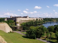
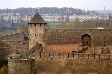
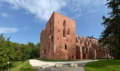
Die Festung Iwangorod wurde unter der Herrschaft Iwans III. im Sommer 1492 am rechten Ufer der Narva ![]() errichtet. Sie bestand noch völlig aus Holz. Die Festung sollte Iwans Anspruch auf Zugang zur Ostsee bekräftigen und zugleich ein Bollwerk gegen den das Baltikum beherrschenden Deutschen Orden bilden. Am linken Ufer stand seit dem 13. Jahrhundert die mächtige Hermannsfeste
errichtet. Sie bestand noch völlig aus Holz. Die Festung sollte Iwans Anspruch auf Zugang zur Ostsee bekräftigen und zugleich ein Bollwerk gegen den das Baltikum beherrschenden Deutschen Orden bilden. Am linken Ufer stand seit dem 13. Jahrhundert die mächtige Hermannsfeste ![]() , eine Burg des Deutschen Ordens.
, eine Burg des Deutschen Ordens.
In den nächsten Jahrzehnten wurden die Anlagen der Festung ständig erweitert und verstärkt. Nach dem Zerfall des Deutschen Ordens kam Estland unter schwedische Herrschaft und seit dem Ende des Livländischen Krieges 1583 gehörte auch Iwangorod ![]() zu Schweden. 1704, während des Großen Nordischen Krieges, eroberte Peter der Große die Festung zurück. Nach dem Zerfall des Zarenreichs kam Iwangorod im Frieden von Dorpat 1920 zur neugegründeten Republik Estland. Nach der Einverleibung Estlands durch die Sowjetunion 1940 wurde Iwangorod Teil der Russischen Sowjetrepublik von 1945. Die Stadt und Festung verblieben nach dem Zerfall der Sowjetunion und der Wiederaufrichtung der unabhängigen Republik Estland 1990 bei Russland.
zu Schweden. 1704, während des Großen Nordischen Krieges, eroberte Peter der Große die Festung zurück. Nach dem Zerfall des Zarenreichs kam Iwangorod im Frieden von Dorpat 1920 zur neugegründeten Republik Estland. Nach der Einverleibung Estlands durch die Sowjetunion 1940 wurde Iwangorod Teil der Russischen Sowjetrepublik von 1945. Die Stadt und Festung verblieben nach dem Zerfall der Sowjetunion und der Wiederaufrichtung der unabhängigen Republik Estland 1990 bei Russland.
Information about copyright | |
|---|---|
Rights characteristic / license | by-sa: CREATIVE COMMONS Attribution-ShareAlike |
Link to the description of the license | |
Input taken over from: |
Seite „Festung Iwangorod“. In: Wikipedia, Die freie Enzyklopädie. Bearbeitungsstand: 25. April 2012, 11:34 UTC. URL: http://de.wikipedia.org/w/index.php?title=Festung_Iwangorod&oldid=102468415 (Abgerufen: 1. September 2012, 16:17 UTC) |
taken over / edited on | 01 Sep 2012 - 07 Feb 2017
|
taken over / edited by |
|
![]()