
Alpe Adria Cycle Route
Actions
![]()
Please wait - map data are loading
Added on 13 Oct 2013,
on 07 Jan 2023
Actions
Cycle route metrics
Total distance in km
404
Information about rights to the gps-track data | |
|---|---|
Rights owner | OpenStreetMap and Contributors + biroto-Redaktion (biroto.eu) |
Rights characteristic / license | Contains information from OpenStreetMap, which is made available here under the Open Database License(ODbL) |
Link to the description of the license | |
GPX file taken from | |
GPX file uploaded | by biroto-Redaktion on 08 Sep 2022
|
Track points in total
6.904
Track points per km (avg)
17
Start/endpoint
Start location
Salzburg, Salzburg, AT (423 m NHN)
End location
Grado, Friuli Venezia Giulia, IT (1 m NHN)
Character
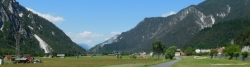
Mit Salzburg als Start-, den Alpen als Etappen- und Grado an der Adria als Zielort verbindet der Radweg äußerst schöne und beliebte Urlaubsziele miteinander. Dadurch und dem Umstand, dass hohe Alpenpässe durch die Tauernschleuse mit dem Zug überbrückt werden und somit wegfallen stellt der Radweg seit seiner Eröffnung 2012 eine beliebte, da technisch und konditionell nicht allzu schwierige Tour eine mittlerweile recht beliebte Transalp dar. Die besten Monate einer Befahrung sind Juni, Juli und September, im August kann es insbesondere im Friaul sehr heiß werden.
Information about copyright | |
|---|---|
Rights characteristic / license | by-sa: CREATIVE COMMONS Attribution-ShareAlike |
Link to the description of the license | |
Input taken over from: |
Seite „Alpe Adria Radweg“. In: Wikipedia, Die freie Enzyklopädie. Bearbeitungsstand: 29. Februar 2016, 09:24 UTC. URL: https://de.wikipedia.org/w/index.php?title=Alpe_Adria_Radweg&oldid=152022218 |
taken over / edited on | 22 Jun 2016 - 06 Sep 2022
|
taken over / edited by |
|
Signposting
In Österreich ist die Route mit dem Alpe-Adria-Logo beschildert. In Italien ist der nördliche Teil der Route ebenso beschildert, der restliche Teil wird nach und nach beschildert werden. |
|

Travel to and from ...
Bustransfers zurück von Italien
Von Grado aus gibt es keine Möglichkeit mit dem Zug zurück zum Startort zu fahren. Von Aquileia ist es schwierg – erst ab Udine ist es möglich! Auch ab Villach gibt es wieder eine Zugverbindung.
Für den Alpe-Adria-Radweg gibt es aber diverse Möglichkeiten, mit dem Bus zurückzukommen, viele der Bustransfers fahren auch nach Salzburg.
Sources of information
Web sites:
- Official site Alpe-Adria-Cycle-Route
Travel reports about cycle tours
27 Jun 2016
95 km
A stage of the tour »Tauern-Adria-Dolomiten-Runde« of user Tandemteam-Traudel_und_Dieter
28 Jun 2016
43 km
A stage of the tour »Tauern-Adria-Dolomiten-Runde« of user Tandemteam-Traudel_und_Dieter
20 May 2016
90 km
A stage of the tour »Spittal - Szeged - Cracow« of user ThimbleU
29 Jun 2016
99 km
A stage of the tour »Tauern-Adria-Dolomiten-Runde« of user Tandemteam-Traudel_und_Dieter

30 Jun 2016
89 km
A stage of the tour »Tauern-Adria-Dolomiten-Runde« of user Tandemteam-Traudel_und_Dieter
Beds4Cyclists, worth visiting and infrastructure
Name and address
Latitude / Longitude
Phone
Fax
Mobile
Type of accommodation
Rating for cyclists
Route km
Dist. to route
Elevation
0 km
0,6 km
422 m
0 km
0,9 km
432 m
0 km
0,1 km
422 m
0 km
0,1 km
422 m
1 km
1,4 km
412 m
![]()