
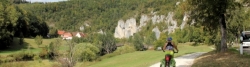
Danube Cycle Route
No. of cycle route D6
Actions
![]()
Please wait - map data are loading
Added on 28 Mar 2012,
last edited by biroto-Redaktion on 01 Nov 2020
Actions
Cycle route metrics
Total distance in km
614
Information about rights to the gps-track data | |
|---|---|
Rights owner | OpenStreetMap and Contributors + biroto-Redaktion (biroto.eu) |
Rights characteristic / license | Contains information from OpenStreetMap, which is made available here under the Open Database License(ODbL) |
Link to the description of the license | |
GPX file taken from | |
GPX file uploaded | by biroto-Redaktion on 01 Nov 2020
|
Track points in total
9.612
Track points per km (avg)
16
Start/endpoint
Start location
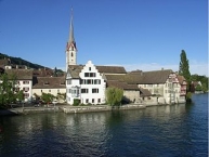
Stein am Rhein, Schaffhausen, CH (405 m NHN)
End location
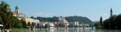
Passau, Bayern, DE (299 m NHN)
Signposting
|
|

Connecting cycle path
In Germany concurrent with the Rivers Route (Atlantic - Black Sea) (EV6).
Travel reports about cycle tours
10 Sep 2018
72 km
A stage of the tour »Upper Danube and Neckar« of user ThimbleU
09 Sep 2018
93 km
A stage of the tour »Upper Danube and Neckar« of user ThimbleU
08 Sep 2018
30 km
A stage of the tour »Upper Danube and Neckar« of user ThimbleU
Information about copyright | |
|---|---|
Rights owner | |
Rights characteristic / license | © all rights reserved. |
Image has been uploaded | by biroto-Redaktion on 04 Nov 2011
|
20 Aug 2010
96 km
A stage of the tour »From Munich via Salzburg, Passau to Günzburg« of user ThimbleU
Information about copyright | |
|---|---|
Rights owner | |
Rights characteristic / license | © all rights reserved. |
Image has been uploaded | by biroto-Redaktion on 04 Nov 2011
|
23 Jul 2011
98 km
A stage of the tour »Passau - Linz - Salzburg - Lake Constance« of user ThimbleU
Beds4Cyclists, worth visiting and infrastructure
Name and address
Latitude / Longitude
Phone
Fax
Mobile
Type of accommodation
Rating for cyclists
Route km
Dist. to route
Elevation
0 km
0,1 km
403 m
Information about copyright | |
|---|---|
Rights owner | |
Rights characteristic / license | by-sa: CREATIVE COMMONS Attribution-ShareAlike |
Link to the description of the license | |
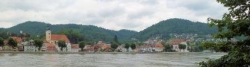
Image taken over from | commons.wikimedia.org/wiki/File:Stein_am_Rhein_(Panorama_Osten).jpg |
Image has been uploaded | by biroto-Redaktion on 17 Dec 2011
|
Information about copyright | |
|---|---|
Rights owner | |
Rights characteristic / license | by-sa: CREATIVE COMMONS Attribution-ShareAlike |
Link to the description of the license | |
Image taken over from | |
Image has been uploaded | by biroto-Redaktion on 17 Dec 2011
|
Information about copyright | |
|---|---|
Rights owner | |
Rights characteristic / license | by-sa: CREATIVE COMMONS Attribution-ShareAlike |
Link to the description of the license | |
Image taken over from | |
Image has been uploaded | by biroto-Redaktion on 17 Dec 2011
|
Information about copyright | |
|---|---|
Rights owner | |
Rights characteristic / license | cc0: Public Domain no Rights reserved |
Link to the description of the license | |
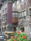
Image taken over from | commons.wikimedia.org/wiki/File:Stein_am_Rhein_-_frescoes.jpg |
Image has been uploaded | by biroto-Redaktion on 17 Dec 2011
|
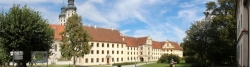
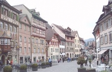
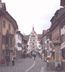
Stein am Rhein is a town in the canton of Schaffhausen in Switzerland. It is situated on the river Rhine, at the westend of Lake Constance (Untersee). It is famous for its medieval town centre, including many half-timbered houses and frescoes. The town is split across the Rhine, with the old town centre on the North side.
Understand
Stein am Rhine was just a small fishing village until 1007, when St. Georges's abbey was moved there. Stein am Rhine was at an intersection between major roadways and the river, and both the town and the abbey prospered. The town now has a population of a little over 3000, and is a popular tourist destination.
See
- ⊙Rathausplatz. A square surrounded by beautiful old buildings.
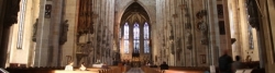
- ⊙St. George's Abbey, ☎ +41 52 741 2142. October to April, 10:00 to 17:00. Closed Mondays. A Benedictine abbey with a late gothic cloister and frescoes dating from 1515.
- ⊙Lindwurm Museum, Understadt 18, ☎ +41 52 741 2512. March to October, 10:00 to 17:00. Tuesdays closed. This museum displays the lifestyle of a middle class family in about 1850. 3.50 CHF.
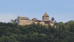
- ⊙Hohenklingen Castle (Up on the hill at the north edge of Stein am Rhein.), ☎ +41 52 741 2137. You can drive to it or walk the stairs up the hillside. From the castle you get a gorgeous view of the town. The best views are (of course) from the restaurant in the castle. Entrance is free.
Information about copyright | |
|---|---|
Rights characteristic / license | by-sa: CREATIVE COMMONS Attribution-ShareAlike |
Link to the description of the license | |
Input taken over from: |
Wikivoyage contributors, 'Stein am Rhein', Wikivoyage, The FREE worldwide travel guide that anyone can edit, 9 May 2016, 15:50 UTC, https://en.wikivoyage.org/w/index.php?title=Stein_am_Rhein&oldid=2992588 |
taken over / edited on | 23 Aug 2016 - 17 May 2021
|
taken over / edited by |
|
0 km
0,0 km
405 m
Hours of opening
| Montag - Freitag | 09.30 - 12.00 13.30 - 17.00 |
| Samstag und Sonntag von Mai bis September | 09.30 - 12.00 13.30 - 16.00 |
0 km
0,9 km
599 m
Information about copyright | |
|---|---|
Rights owner | |
Rights characteristic / license | by-sa: CREATIVE COMMONS Attribution-ShareAlike |
Link to the description of the license | |
Image taken over from | |
Image has been uploaded | by biroto-Redaktion on 22 Apr 2013
|
Information about copyright | |
|---|---|
Rights owner | |
Rights characteristic / license | by-sa: CREATIVE COMMONS Attribution-ShareAlike |
Link to the description of the license | |
Image taken over from | |
Image has been uploaded | by biroto-Redaktion on 22 Apr 2013
|
Information about copyright | |
|---|---|
Rights owner | |
Rights characteristic / license | by-sa: CREATIVE COMMONS Attribution-ShareAlike |
Link to the description of the license | |
Image taken over from | |
Image has been uploaded | by biroto-Redaktion on 22 Apr 2013
|
Information about copyright | |
|---|---|
Rights owner | |
Rights characteristic / license | by-sa: CREATIVE COMMONS Attribution-ShareAlike |
Link to the description of the license | |
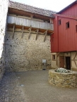
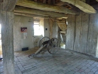
Image taken over from | commons.wikimedia.org/wiki/File:Hohenklingen_Dachgeschoss.jpg |
Image has been uploaded | by biroto-Redaktion on 22 Apr 2013
|
Die Burg Hohenklingen ist eine Burganlage bei Stein am Rhein ![]() im Kanton Schaffhausen in der Schweiz. Sie liegt fast 200 Meter oberhalb des Städtchens auf einem schmalen, von Ost nach West verlaufenden Nagelfluhgrat
im Kanton Schaffhausen in der Schweiz. Sie liegt fast 200 Meter oberhalb des Städtchens auf einem schmalen, von Ost nach West verlaufenden Nagelfluhgrat ![]() , dem Schiener Berg
, dem Schiener Berg ![]() .
.
Die Burg Hohenklingen blieb im Verlauf ihrer Geschichte von kriegerischen Zerstörungen verschont. Ihre Silhouette mit Mauern und Dächern entspricht auch heute noch dem mittelalterlichen Erscheinungsbild von 1200 bis 1422.
Information about copyright | |
|---|---|
Rights characteristic / license | by-sa: CREATIVE COMMONS Attribution-ShareAlike |
Link to the description of the license | |
Input taken over from: |
Seite „Burg Hohenklingen“. In: Wikipedia, Die freie Enzyklopädie. Bearbeitungsstand: 3. April 2013, 03:38 UTC. URL: http://de.wikipedia.org/w/index.php?title=Burg_Hohenklingen&oldid=116711787 (Abgerufen: 22. April 2013, 21:27 UTC) |
taken over / edited on | 22 Apr 2013
|
taken over / edited by |
|
1 km
0,3 km
431 m
1 km
0,9 km
415 m
![]()