
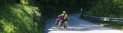
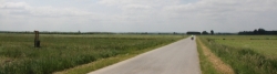
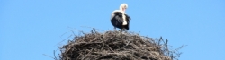
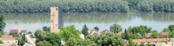
Drava Cycle Route
Actions
![]()
Please wait - map data are loading
Added on 09 Apr 2012,
last edited by biroto-Redaktion on 10 Jan 2024
Actions
Cycle route metrics
Total distance in km
744
Information about rights to the gps-track data | |
|---|---|
Rights owner | OpenStreetMap and Contributors + biroto-Redaktion (biroto.eu) |
Rights characteristic / license | Contains information from OpenStreetMap, which is made available here under the Open Database License(ODbL) |
Link to the description of the license | |
GPX file taken from | |
GPX file uploaded | by biroto-Redaktion on 10 Jan 2024
|
Track points in total
11.003
Track points per km (avg)
15
Start/endpoint
Start location
Dobbiaco, 32, IT (1211 m NHN)
End location
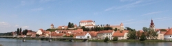
Erdut, HR (92 m NHN)
Signposting
in Österreich |
|
| |
in Slovenien |
|
in Kroatien |
|
| |
zukünftige einheitliche Beschilderung |
|


Sources of information
Portale:
- Homepage des Drauradweges von der Quelle bis Maribor
Bücher:
- Esterbauer bikeline: Drau-Radweg
Von der Quelle nach Maribor. Radtourenbuch 1:50.000, 360 km, wetterfest/reißfest
Travel reports about cycle tours
17 May 2022
82 km
A stage of the tour »Northern Italy round trip part 1« of user ThimbleU
16 May 2022
88 km
A stage of the tour »Northern Italy round trip part 1« of user ThimbleU
20 May 2016
90 km
A stage of the tour »Spittal - Szeged - Cracow« of user ThimbleU
21 May 2016
84 km
A stage of the tour »Spittal - Szeged - Cracow« of user ThimbleU
22 May 2016
70 km
A stage of the tour »Spittal - Szeged - Cracow« of user ThimbleU
23 May 2016
95 km
A stage of the tour »Spittal - Szeged - Cracow« of user ThimbleU
24 May 2016
97 km
A stage of the tour »Spittal - Szeged - Cracow« of user ThimbleU
25 May 2016
80 km
A stage of the tour »Spittal - Szeged - Cracow« of user ThimbleU
26 May 2016
105 km
A stage of the tour »Spittal - Szeged - Cracow« of user ThimbleU
Information about copyright | |
|---|---|
Rights owner | |
Rights characteristic / license | © all rights reserved. |
Image has been uploaded | by ThimbleU on 20 Jun 2016
|
27 May 2016
92 km
A stage of the tour »Spittal - Szeged - Cracow« of user ThimbleU
Beds4Cyclists, worth visiting and infrastructure
Name and address
Latitude / Longitude
Phone
Fax
Mobile
Type of accommodation
Rating for cyclists
Route km
Dist. to route
Elevation
0 km
0,9 km
1.223 m
0 km
0,2 km
1.211 m
0 km
4,6 km
1.144 m
Hours of opening
Mo-Fr: 9.00-12.00 Uhr und 15.00 – 18.00 Uhr
Sa: 9.00-12.00 Uhr
An Sonn- und Feiertagen geschlossen
August:
Mo-Sa: 9.00-12.00 Uhr und 15.00 – 18.00 Uhr
So: 10.00-12.00 Uhr
15. August: 11.00-12.00 Uhr
0 km
0,5 km
1.207 m
Hours of opening
Mo-Fr: 9.00 – 12.00 Uhr und 15.00 – 18.00 Uhr
Sa: 9.00 – 12.00 Uhr
An Sonn- und Feiertagen geschlossen
Juli und August:
Mo-Fr: 8.30 – 12.30 Uhr und 13.30 – 19.00 Uhr
Sa: 9.00 – 12.30 Uhr und 14.00 – 18.00 Uhr
So: 10.00 – 12.00 Uhr
15.8. geschlossen
Weihnachten/Neujahr:
zusätzlich am Sonntag und an Feiertagen außer 25.12. und 1.1. von 10.00 – 12.00 Uhr geöffnet
0 km
1,2 km
1.245 m
Information about copyright | |
|---|---|
Rights owner | |
Rights characteristic / license | by-sa: CREATIVE COMMONS Attribution-ShareAlike |
Link to the description of the license | |
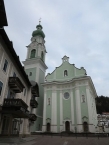
Image taken over from | commons.wikimedia.org/wiki/File:Toblach_PfarrkircheA_2013.JPG |
Image has been uploaded | by biroto-Redaktion on 22 Sep 2013
|
Information about copyright | |
|---|---|
Rights owner | |
Rights characteristic / license | by-sa: CREATIVE COMMONS Attribution-ShareAlike |
Link to the description of the license | |
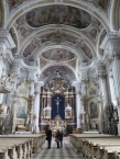
Image taken over from | commons.wikimedia.org/wiki/File:Toblach_PfarrkircheI_2013.JPG |
Image has been uploaded | by biroto-Redaktion on 22 Sep 2013
|
Information about copyright | |
|---|---|
Rights owner | |
Rights characteristic / license | by-sa: CREATIVE COMMONS Attribution-ShareAlike |
Link to the description of the license | |
Image taken over from | |
Image has been uploaded | by biroto-Redaktion on 22 Sep 2013
|
Information about copyright | |
|---|---|
Rights owner | |
Rights characteristic / license | by-sa: CREATIVE COMMONS Attribution-ShareAlike |
Link to the description of the license | |
Image taken over from | commons.wikimedia.org/wiki/File:Toblach_Herbstenburg_2013.JPG |
Image has been uploaded | by biroto-Redaktion on 22 Sep 2013
|
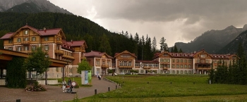
Toblach (italienisch Dobbiaco) ist eine Gemeinde mit 3399 Einwohnern (2012) im Südtiroler Pustertal in Italien. Das Dorf, das sich in Alt- und Neu-Toblach aufteilt, befindet sich auf einem Schuttkegel des Silvesterbaches. Hier auf dem Toblacher Feld verläuft die Wasserscheide zwischen Adria und Schwarzem Meer.
Sehenswürdigkeiten
Sehenswürdigkeiten von Toblach sind:
- ⊙die Pfarrkirche zum Hl. Johannes dem Täufer
 : eine Barockkirche auf den Fundamenten einer romanischen und später gotischen Kirche erbaut. Sie zählt zu den stattlichsten Barockkirchen des Pustertals.
 - ⊙der älteste Kreuzweg Tirols: 5 Passionskapellen entlang der Maximilianstraße
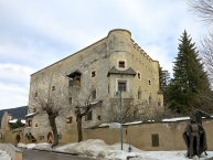
- ⊙der im Jahre 1500 durch die Gebrüder Konrad und Christoph von Herbst erbaute Ansitz Herbstenburg
- ⊙der „Rote Turm“, 1430 erbaut
- ⊙das Grand Hotel Toblach , mit Naturparkhaus
- der Toblacher See und der Dürrensee
Information about copyright | |
|---|---|
Rights characteristic / license | by-sa: CREATIVE COMMONS Attribution-ShareAlike |
Link to the description of the license | |
Input taken over from: |
Seite „Toblach“. In: Wikipedia, Die freie Enzyklopädie. Bearbeitungsstand: 7. Mai 2013, 15:20 UTC. URL: http://de.wikipedia.org/w/index.php?title=Toblach&oldid=118283142 |
taken over / edited on | 22 Sep 2013 - 05 May 2022
|
taken over / edited by |
|
![]()