
Eifel-Ardennen-Cycle Route
Actions
![]()
Please wait - map data are loading
Added on 18 Jul 2019,
last edited by biroto-Redaktion on 05 Nov 2023
Actions
Cycle route metrics
Total distance in km
109
Information about rights to the gps-track data | |
|---|---|
Rights owner | OpenStreetMap and Contributors + biroto-Redaktion (biroto.eu) |
Rights characteristic / license | Contains information from OpenStreetMap, which is made available here under the Open Database License(ODbL) |
Link to the description of the license | |
GPX file taken from | |
GPX file uploaded | by biroto-Redaktion on 05 Nov 2023
|
Track points in total
2.188
Track points per km (avg)
20
Start/endpoint
Start location
Nürburg, RP, DE (609 m NHN)
End location
Sankt-Vith, WAL, BE (460 m NHN)
Signposting
|

Beds4Cyclists, worth visiting and infrastructure
Name and address
Latitude / Longitude
Phone
Fax
Mobile
Type of accommodation
Rating for cyclists
Route km
Dist. to route
Elevation
11 km
1,0 km
504 m
24 km
4,0 km
419 m
27 km
0,2 km
434 m
27 km
0,3 km
438 m
27 km
0,3 km
421 m
Information about copyright | |
|---|---|
Rights owner | |
Rights characteristic / license | by-sa: CREATIVE COMMONS Attribution-ShareAlike |
Link to the description of the license | |
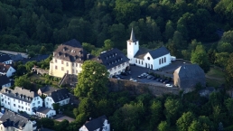
Image taken over from | https://commons.wikimedia.org/wiki/File:Daun_009x_Burg_Daun.jpg |
Image has been uploaded | by biroto-Redaktion on 09 Jan 2021
|
Information about copyright | |
|---|---|
Rights owner | |
Rights characteristic / license | by-sa: CREATIVE COMMONS Attribution-ShareAlike |
Link to the description of the license | |
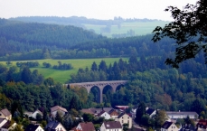
Image taken over from | https://commons.wikimedia.org/wiki/File:Daun,_Eisenbahnviadukt_(2).jpg |
Image has been uploaded | by biroto-Redaktion on 09 Jan 2021
|
Daun ist Sitz der Kreisverwaltung des Landkreises Vulkaneifel in Rheinland-Pfalz sowie ein heilklimatischer und Kneippkurort.
Sie befindet sich südlich der Hohen Eifel ![]() am Fluss Lieser
am Fluss Lieser ![]() . Die Landschaft ist durch den vulkanischen Charakter geprägt. 2,5 km bis 3,5 km südöstlich vom Dauner Stadtkern befinden sich die sogenannten Dauner Maare, drei unmittelbar aneinandergrenzende Maare, die nur durch ihre Tuffwälle getrennt sind.
. Die Landschaft ist durch den vulkanischen Charakter geprägt. 2,5 km bis 3,5 km südöstlich vom Dauner Stadtkern befinden sich die sogenannten Dauner Maare, drei unmittelbar aneinandergrenzende Maare, die nur durch ihre Tuffwälle getrennt sind.
Sehenswürdigkeiten
Bauwerke
- ⊙Burg Daun

- Kurtrierisches Amtshaus (heute Hotel) von 1712
- Evangelische Kirche (1865/67)
- Zehntscheune von 1740
- Burgmannenhäuser: Waldenhof, Hof Rademacher
- ⊙Dauner Viadukt , Eisenbahnbrücke von 1909
Museen
- ⊙Vulkanmuseum Daun, Leopoldstr. 9, Daun, ☎ +49 6592 985 353
Das Vulkanmuseum im alten Dauner Landratsamt ist als Ergänzung zu den bestehenden Geopfaden Hillesheim, Manderscheid und Gerolstein entstanden und Teil des Natur- und Geoparks Vulkaneifel.Neben vielen Informationstafeln vermitteln Fotos und Exponate aus der Vulkaneifel, aber auch von zurzeit noch aktiven Vulkanen aus Europa und Asien Einblicke in die erdgeschichtliche Entwicklung der Vulkaneifel.
Information about copyright | |
|---|---|
Rights characteristic / license | by-sa: CREATIVE COMMONS Attribution-ShareAlike |
Link to the description of the license | |
Input taken over from: |
Seite „Daun“. In: Wikipedia, Die freie Enzyklopädie. Bearbeitungsstand: 31. Dezember 2020, 17:14 UTC. URL: https://de.wikipedia.org/w/index.php?title=Daun&oldid=207110328 (Abgerufen: 9. Januar 2021, 12:04 UTC) |
taken over / edited on | 09 Jan 2021
|
taken over / edited by |
|
![]()