
Cycle Route Kingfisher Cycle Trail
Actions
![]()
Please wait - map data are loading
Added on 17 Jan 2019,
last edited by biroto-Redaktion on 04 Nov 2023
Actions
Cycle route metrics
Total distance in km
358
Information about rights to the gps-track data | |
|---|---|
Rights owner | OpenStreetMap and Contributors + biroto-Redaktion (biroto.eu) |
Rights characteristic / license | Contains information from OpenStreetMap, which is made available here under the Open Database License(ODbL) |
Link to the description of the license | |
GPX file taken from | |
GPX file uploaded | by biroto-Redaktion on 04 Nov 2023
|
Track points in total
5.785
Track points per km (avg)
16
Start/endpoint
Start location
Carrick-on-Shannon, IE (46 m NHN)
End location
Carrick-on-Shannon, IE (47 m NHN)
Beds4Cyclists, worth visiting and infrastructure
Name and address
Latitude / Longitude
Phone
Fax
Mobile
Type of accommodation
Rating for cyclists
Route km
Dist. to route
Elevation
121 km
0,4 km
39 m
Information about copyright | |
|---|---|
Rights owner | https://www.panoramio.com/user/7590076?with_photo_id=95905461 |
Rights characteristic / license | by: CREATIVE COMMONS Attribution |
Link to the description of the license | |
Image taken over from | https://commons.wikimedia.org/wiki/File:Crom_Castle_-_panoramio_(6).jpg |
Image has been uploaded | by ThimbleU on 18 Jan 2019
|
Information about copyright | |
|---|---|
Rights owner | |
Rights characteristic / license | by: CREATIVE COMMONS Attribution |
Link to the description of the license | |
Image taken over from | https://commons.wikimedia.org/wiki/File:Crom_Castle_in_2008.jpg |
Image has been uploaded | by ThimbleU on 18 Jan 2019
|
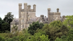
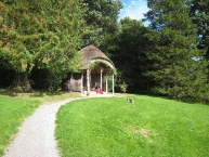
Crom Castle (Irish: Caisleán na Croime) is situated on the shores of the Upper Lough Erne ![]() in County Fermanagh, Northern Ireland, and set within a 1,900-acre (7.7 km2) estate.
in County Fermanagh, Northern Ireland, and set within a 1,900-acre (7.7 km2) estate.
History
The present structure was built in 1820 and, although Queen Victoria's reign began in 1837, the building was built in the Victorian style and has since been the home to the Creighton (later Crichton) family, Earls of Erne.
Crom Estate also contains the ruins of the Old Castle, a tower house, which was previously owned by the Balfour family until the Creightons acquired it in 1609.
Today
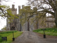
The castle is privately owned by the Creighton family, Earls of Erne, and the estate is managed by the National Trust.
The estate includes many features of times past including the old farmyard and visitors centre, The boathouse, once the home of Lough Erne Yacht Club, the tea house, the church, schoolhouse, etc. Guests are able to use the west wing for weddings, or to stay in the West Wing of Crom Castle on weekly or long weekend basis.
Information about copyright | |
|---|---|
Rights characteristic / license | by-sa: CREATIVE COMMONS Attribution-ShareAlike |
Link to the description of the license | |
Input taken over from: |
Wikipedia contributors, 'Crom Castle', Wikipedia, The Free Encyclopedia, 10 June 2018, 01:36 UTC, <https://en.wikipedia.org/w/index.php?title=Crom_Castle&oldid=845187251> [accessed 18 January 2019] |
taken over / edited on | 18 Jan 2019
|
taken over / edited by |
|
161 km
2,3 km
81 m
Information about copyright | |
|---|---|
Rights owner | |
Rights characteristic / license | by-sa: CREATIVE COMMONS Attribution-ShareAlike |
Link to the description of the license | |
Image taken over from | https://commons.wikimedia.org/wiki/File:Florence_Court_frontage.jpg |
Image has been uploaded | by biroto-Redaktion on 17 Jan 2019
|
Information about copyright | |
|---|---|
Rights owner | |
Rights characteristic / license | by: CREATIVE COMMONS Attribution |
Link to the description of the license | |
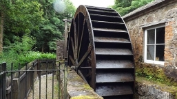
Image taken over from | https://commons.wikimedia.org/wiki/File:Water_Wheel_at_Florence_Court_-_panoramio_(1).jpg |
Image has been uploaded | by biroto-Redaktion on 17 Jan 2019
|
Information about copyright | |
|---|---|
Rights owner | |
Rights characteristic / license | by-sa: CREATIVE COMMONS Attribution-ShareAlike |
Link to the description of the license | |
Image taken over from | |
Image has been uploaded | by biroto-Redaktion on 17 Jan 2019
|
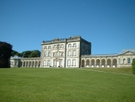
Florence Court is a large 18th-century house and estate located 8 miles south-west of Enniskillen ![]() , County Fermanagh, Northern Ireland. It is set in the foothills of Cuilcagh Mountain. The nearby village is distinguished by the one-word name Florencecourt
, County Fermanagh, Northern Ireland. It is set in the foothills of Cuilcagh Mountain. The nearby village is distinguished by the one-word name Florencecourt ![]() . It is owned and managed by the National Trust and is the sister property of nearby Castle Coole
. It is owned and managed by the National Trust and is the sister property of nearby Castle Coole ![]() .
.
The house features exquisite Rococo decoration and fine Irish furniture, many pieces of which were acquired for the property by the National Trust and others loaned from other Irish houses. The majority of the original furnishings were removed when the Cole family moved to Perthshire in 1973 but many were returned at the bequest of the Dowager Countess of Enniskillen on her death in 1998.
Information about copyright | |
|---|---|
Rights characteristic / license | by-sa: CREATIVE COMMONS Attribution-ShareAlike |
Link to the description of the license | |
Input taken over from: |
Wikipedia contributors, 'Florence Court', Wikipedia, The Free Encyclopedia, 9 April 2018, 13:12 UTC, <https://en.wikipedia.org/w/index.php?title=Florence_Court&oldid=835562564> [accessed 17 January 2019] |
taken over / edited on | 17 Jan 2019
|
taken over / edited by |
|
Hours of opening
Admission to Castle Coole is by guided tour only. Please consult the National Trust's webpage via the external link for opening times.
174 km
0,0 km
42 m
Information about copyright | |
|---|---|
Rights owner | |
Rights characteristic / license | by-sa: CREATIVE COMMONS Attribution-ShareAlike |
Link to the description of the license | |
Image taken over from | https://commons.wikimedia.org/wiki/File:Enniskillen_Castle_02.jpg |
Image has been uploaded | by biroto-Redaktion on 17 Jan 2019
|
Information about copyright | |
|---|---|
Rights owner | |
Rights characteristic / license | by: CREATIVE COMMONS Attribution |
Link to the description of the license | |
Image taken over from | https://commons.wikimedia.org/wiki/File:Enniskillen_Castle_03.jpg |
Image has been uploaded | by biroto-Redaktion on 17 Jan 2019
|
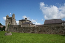
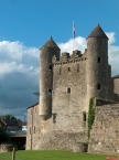
Enniskillen Castle is situated in Enniskillen ![]() , County Fermanagh, Northern Ireland. It was originally built in the 16th century and now houses the Fermanagh County Museum and the regimental museum of the Royal Inniskilling Fusiliers and the 5th Royal Inniskilling Dragoon Guards.
, County Fermanagh, Northern Ireland. It was originally built in the 16th century and now houses the Fermanagh County Museum and the regimental museum of the Royal Inniskilling Fusiliers and the 5th Royal Inniskilling Dragoon Guards.
History
The first Enniskillen castle was built on this site by Hugh Macguire in 1428. It featured greatly in Irish rebellions against English rule in the 16th century and was taken after an eight-day siege in 1594. Captain William Cole remodelled and refurbished the castle adding the riverside tower at the south, known as the Watergate, in 1609. The castle was remodelled as “Castle Barracks” as part of the response to a threat of a French invasion in 1796. Castle Barracks became the home of the 27th Regiment of Foot in 1853. The regiment moved to purpose-built facilities at St Lucia Barracks, Omagh in 1875 and evolved, after amalgamation, to become the Royal Inniskilling Fusiliers in 1881.
The barracks continued to be used by other regiments and, from November 1939, they became to home of the North Irish Horse, a Territorial Army unit. The barracks were decommissioned in 1950 and were converted for use as council depot. The castle was subsequently opened to the public as a heritage centre.
Features and collections
The Castle provided the main defence for the west end of the town and guarded the Sligo ![]() road. It consists of two sections, a central tower keep and a curtain wall which was strengthened with small turrets called Bartizans. The design of the castle has strong Scottish influences. This can be particularly seen in the Watergate, which features two corbelled circular tourelles which were built about 1609. It is a State Care Historic Monument.
road. It consists of two sections, a central tower keep and a curtain wall which was strengthened with small turrets called Bartizans. The design of the castle has strong Scottish influences. This can be particularly seen in the Watergate, which features two corbelled circular tourelles which were built about 1609. It is a State Care Historic Monument.
The castle is now home to the Fermanagh County Museum, which focuses on the county's history, culture and natural history. Exhibits include the area's prehistory, natural history, traditional rural life, local crafts and Belleek Pottery, and history of the castle. It also contains information on the Maguire family. The castle also houses the Inniskillings Museum, which is the regimental museum of the Royal Inniskilling Fusiliers and the 5th Royal Inniskilling Dragoon Guards.
Information about copyright | |
|---|---|
Rights characteristic / license | by-sa: CREATIVE COMMONS Attribution-ShareAlike |
Link to the description of the license | |
Input taken over from: |
Wikipedia contributors, 'Enniskillen Castle', Wikipedia, The Free Encyclopedia, 3 December 2018, 06:24 UTC, <https://en.wikipedia.org/w/index.php?title=Enniskillen_Castle&oldid=871757422> [accessed 17 January 2019] |
taken over / edited on | 17 Jan 2019
|
taken over / edited by |
|
Hours of opening
Monday to Friday (all year round): 9.30am - 5.00pm
Saturdays (all year round): 11.00am - 5.00pm
Sundays (Jun to Sept): 11.00am - 5.00pm
176 km
0,1 km
46 m
176 km
1,0 km
48 m
Information about copyright | |
|---|---|
Rights owner | |
Rights characteristic / license | by-sa: CREATIVE COMMONS Attribution-ShareAlike |
Link to the description of the license | |
Image taken over from | https://commons.wikimedia.org/wiki/File:Castle_Coole_Frontage.JPG |
Image has been uploaded | by biroto-Redaktion on 17 Jan 2019
|
Information about copyright | |
|---|---|
Rights owner | |
Rights characteristic / license | by-sa: CREATIVE COMMONS Attribution-ShareAlike |
Link to the description of the license | |
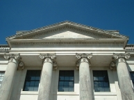
Image taken over from | https://commons.wikimedia.org/wiki/File:Castle_Coole_Portico_Detail.jpg |
Image has been uploaded | by biroto-Redaktion on 17 Jan 2019
|
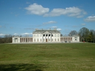
Castle Coole (from Irish: Cúl) is a townland and a late-18th-century neo-classical mansion situated in Enniskillen ![]() , County Fermanagh, Northern Ireland. Set in a 1,200-acre (490 ha) wooded estate, it is one of three properties owned and managed by the National Trust in County Fermanagh.
, County Fermanagh, Northern Ireland. Set in a 1,200-acre (490 ha) wooded estate, it is one of three properties owned and managed by the National Trust in County Fermanagh.
The townland, which is 529 acres (214 ha) in size, is situated in the civil parish of Derryvullan, in the historic barony of Tirkennedy, as well as Fermanagh and Omagh district.
History
The Castle Coole estate was purchased in 1656 by the Belfast merchant John Corry, grandfather of the first Earl. The estate is named for Lough Coole (from Irish Gaelic cúil, 'seclusion'), a lake surrounded by the Killynure hills. A ráth here and a crannog in Lough Coole itself are reminders that the area has been settled since prehistoric times. Other lakes on the estate include Lough Yoan and Brendrum Lough.
The site of a 17th-century house and bawn and formal garden at Castle Coole (grid ref: H2574 4333) are Scheduled Historic Monuments.
Castle Coole was constructed between 1789 and 1798 as the summer retreat of Armar Lowry-Corry, the 1st Earl Belmore.
Following the passage in 1800 of the Act of Union, the law politically uniting Britain and Ireland, the family moved from their main residence – a small townhouse in Sackville Street, Dublin – to Castle Coole, as the reason for living in Dublin, to be close to the Parliament, no longer applied.
In 1951 the 7th Earl Belmore transferred the mansion to the National Trust, prompted by two sets of death duties or inheritance tax when the 5th and 6th Earls Belmore died without issue 18 months apart. However, the contents of the mansion, including much that is today shown to visitors, remain the Earl Belmore's property.
Information about copyright | |
|---|---|
Rights characteristic / license | by-sa: CREATIVE COMMONS Attribution-ShareAlike |
Link to the description of the license | |
Input taken over from: |
Wikipedia contributors, 'Castle Coole', Wikipedia, The Free Encyclopedia, 1 July 2018, 01:24 UTC, <https://en.wikipedia.org/w/index.php?title=Castle_Coole&oldid=848293262> [accessed 17 January 2019] |
taken over / edited on | 17 Jan 2019
|
taken over / edited by |
|
Hours of opening
Admission to Castle Coole is by guided tour only. Please consult the National Trust's webpage via the external link for opening times.