
Cycle Route La Hennuyère-Fagne-Famenne
No. of cycle route RV3
Actions
![]()
Please wait - map data are loading
Added on 25 Nov 2011,
last edited by biroto-Redaktion on 27 Nov 2020
Actions
Cycle route metrics
Total distance in km
227
Information about rights to the gps-track data | |
|---|---|
Rights owner | OpenStreetMap and Contributors + biroto-Redaktion (biroto.eu) |
Rights characteristic / license | Contains information from OpenStreetMap, which is made available here under the Open Database License(ODbL) |
Link to the description of the license | |
GPX file taken from | |
GPX file uploaded | by biroto-Redaktion on 27 Nov 2020
|
Track points in total
3.616
Track points per km (avg)
16
Start/endpoint
Start location
Geraardsbergen, Flanders, BE (16 m NHN)
End location
Gedinne, Wallonia, BE (396 m NHN)
Beds4Cyclists, worth visiting and infrastructure
Name and address
Latitude / Longitude
Phone
Fax
Mobile
Type of accommodation
Rating for cyclists
Route km
Dist. to route
Elevation
38 km
0,1 km
78 m
51 km
4,9 km
101 m
89 km
0,1 km
112 m
Hours of opening
September to June:
Open from Tuesday to Friday from 09:00 to 12:00 and from 12:30 to 16:00.
July and August:
Open Tuesday to Friday from 9am to 12pm and from 12h30 to 16h00 and weekends from 10h to 16h.
Closed Mondays and holidays.
91 km
0,4 km
114 m
Information about copyright | |
|---|---|
Rights owner | |
Rights characteristic / license | by: CREATIVE COMMONS Attribution |
Link to the description of the license | |
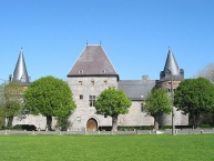
Image taken over from | commons.wikimedia.org/wiki/File:00_Solre-sur-Sambre_JPG2.jpg |
Image has been uploaded | by biroto-Redaktion on 01 Apr 2015
|
Information about copyright | |
|---|---|
Rights owner | |
Rights characteristic / license | by-sa: CREATIVE COMMONS Attribution-ShareAlike |
Link to the description of the license | |
Image taken over from | |
Image has been uploaded | by biroto-Redaktion on 01 Apr 2015
|
Information about copyright | |
|---|---|
Rights owner | |
Rights characteristic / license | by: CREATIVE COMMONS Attribution |
Link to the description of the license | |
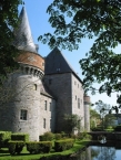
Image taken over from | commons.wikimedia.org/wiki/File:00_Solre-sur-Sambre_JPG4.jpg |
Image has been uploaded | by biroto-Redaktion on 01 Apr 2015
|
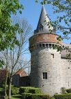
Solre-sur-Sambre Castle (French: Château de Solre-sur-Sambre) is a castle in Solre-sur-Sambre in the municipality of Erquelinnes ![]() , province of Hainaut, Belgium.
, province of Hainaut, Belgium.
The castle was built around the turn of the 13th and 14th centuries and retains much of the medieval structure. It is the property of the Princes de Merode.
Information about copyright | |
|---|---|
Rights characteristic / license | by-sa: CREATIVE COMMONS Attribution-ShareAlike |
Link to the description of the license | |
Input taken over from: |
Wikipedia contributors, 'Solre-sur-Sambre Castle', Wikipedia, The Free Encyclopedia, 11 March 2013, 17:35 UTC, <http://en.wikipedia.org/w/index.php?title=Solre-sur-Sambre_Castle&oldid=543459268> [accessed 1 April 2015] |
taken over / edited on | 01 Apr 2015
|
taken over / edited by |
|
112 km
4,3 km
180 m
![]()