
Radweg La Transwallone
Nr. des Radweges RV8
Aktionen
![]()
Bitte warten - Kartendaten werden geladen
Erstellt am 25.11.2011,
zuletzt geändert von biroto-Redaktion am 27.11.2020
Aktionen
Strecken-Merkmale
Gesamtlänge in km
406
Informationen zu Rechten an den GPS-Track-Daten | |
|---|---|
Rechte-Inhaber | OpenStreetMap and Contributors + biroto-Redaktion (biroto.eu) |
Rechte-Ausprägung / Lizenz | Enthält Daten von OpenStreetMap, die hier unter der Open Database License(ODbL) verfügbar gemacht werden |
Link zur Rechtebeschreibung | |
gpx-Datei übernommen aus | |
gpx-Datei hochgeladen | durch biroto-Redaktion am 27.11.2020
|
Gesamtzahl Trackpoints
5.707
Trackpoint-Dichte per km
14
Endorte
Start
Mont-de-l'Enclus, Wallonia, BE (112 m NHN)
Ziel
Ulflingen, LU (501 m NHN)
Fahrradfreundliche Unterkünfte, Sehenswertes und Infrastruktur
Name u. Anschrift
Breite / Länge
Tel.
Fax.
Mobile
Art d. Unterkunft
Radler-freund-lichkeit
Strecken-km
km zur Strecke
Höhe
28 km
0,2 km
14 m
114 km
4,9 km
114 m
Informationen zu Urheber-Rechten | |
|---|---|
Rechte-Inhaber | |
Rechte-Ausprägung / Lizenz | by: CREATIVE COMMONS Namensnennung |
Link zur Rechtebeschreibung | |
Bild übernommen aus | commons.wikimedia.org/wiki/File:00_Solre-sur-Sambre_JPG2.jpg |
Bild hochgeladen | durch biroto-Redaktion am 01.04.2015
|
Informationen zu Urheber-Rechten | |
|---|---|
Rechte-Inhaber | |
Rechte-Ausprägung / Lizenz | by-sa: CREATIVE COMMONS Namensnennung, Weitergabe unter gleichen Bedingungen |
Link zur Rechtebeschreibung | |
Bild übernommen aus | |
Bild hochgeladen | durch biroto-Redaktion am 01.04.2015
|
Informationen zu Urheber-Rechten | |
|---|---|
Rechte-Inhaber | |
Rechte-Ausprägung / Lizenz | by: CREATIVE COMMONS Namensnennung |
Link zur Rechtebeschreibung | |
Bild übernommen aus | commons.wikimedia.org/wiki/File:00_Solre-sur-Sambre_JPG4.jpg |
Bild hochgeladen | durch biroto-Redaktion am 01.04.2015
|
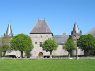
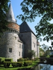
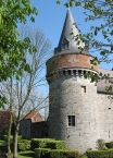
Solre-sur-Sambre Castle (French: Château de Solre-sur-Sambre) is a castle in Solre-sur-Sambre in the municipality of Erquelinnes ![]() , province of Hainaut, Belgium.
, province of Hainaut, Belgium.
The castle was built around the turn of the 13th and 14th centuries and retains much of the medieval structure. It is the property of the Princes de Merode.
Informationen zu Urheber-Rechten | |
|---|---|
Rechte-Ausprägung / Lizenz | by-sa: CREATIVE COMMONS Namensnennung, Weitergabe unter gleichen Bedingungen |
Link zur Rechtebeschreibung | |
Text(e) übernommen von: |
Wikipedia contributors, 'Solre-sur-Sambre Castle', Wikipedia, The Free Encyclopedia, 11 March 2013, 17:35 UTC, <http://en.wikipedia.org/w/index.php?title=Solre-sur-Sambre_Castle&oldid=543459268> [accessed 1 April 2015] |
übernommen / bearbeitet am | 01.04.2015
|
übernommen / bearbeitet durch |
|
123 km
0,3 km
160 m
Informationen zu Urheber-Rechten | |
|---|---|
Rechte-Inhaber | |
Rechte-Ausprägung / Lizenz | by: CREATIVE COMMONS Namensnennung |
Link zur Rechtebeschreibung | |
Bild übernommen aus | https://commons.wikimedia.org/wiki/File:Thuin_-_jardins_suspendus_-_2018-09-09_-_16.jpg |
Bild hochgeladen | durch biroto-Redaktion am 09.06.2023
|
Informationen zu Urheber-Rechten | |
|---|---|
Rechte-Inhaber | |
Rechte-Ausprägung / Lizenz | by-sa: CREATIVE COMMONS Namensnennung, Weitergabe unter gleichen Bedingungen |
Link zur Rechtebeschreibung | |
Bild übernommen aus | https://commons.wikimedia.org/wiki/File:Thuin_-_beffroi_-_2018-09-08_-_01.jpg |
Bild hochgeladen | durch biroto-Redaktion am 09.06.2023
|
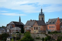
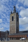
Thuin is a small, partly hilltop town south-west of Charleroi in the Belgian province of Hainaut on the river Sambre. For rail fans, there is the ASVi museum featuring historic trams from the Vicinal era.
Understand
The municipality of Thuin (roughly pronounced TWAYNg) consists of the lower town (ville basse) and the upper town (ville-haute) plus a number of surrounding villages and the country-side in between. Lobbes is a nearby independent municipality. In the centre of Thuin, buildings in the upper town are generally older than those in the lower town.
See
- ⊙Belfry (Beffroi)
 (in the main square). The belfry, dating from the 17th century, has been named a
  UNESCO World Heritage Site. A splendid view on the Thuin area can be seen from the top. If you don't feel like climbing the Belfry, you can still get a good view from Place du Chapitre, the square beside the Belfry.
 - ⊙North Wall (Rempart du Nord). The medieval wall offers a good view of the Sambre Valley. On the wall, next to Place du Chapitre, an old cannon nicknamed Le Spantôle can be seen.
- ⊙Grand-Rue. There are a number of older buildings along this narrow street in the upper town.
- ⊙Hanging Gardens (Jardins suspendus). The charming Hanging Gardens on the southern flank of the Thuin hill can be visited on foot, following a path enhanced by several explanation signs.
- ⊙Notre-Dame d'El Vaulx. In this church in the lower town there is a 12th-century oak statue of sedes sapientiae (our lady of wisdom). There is a vaulted passageway under the choir.
- ⊙Tram Museum (ASVi museum), Rue du Fosteau 2A, ☎ +32 71 370005. Open only certain days of the week from April to October.
Tram operation (circulations) is generally only on Sundays plus Saturdays in July and August. Specializing in the history of the Belgian Vicinal tramway system. This includes a museum tramway with 3 routes. One route runs through the streets of the lower town to Place de la Ville-Basse. A second route runs to the nearby town of Lobbes. Until 1983, both of these routes were part of a much longer route used by electric trams that extended to Anderlues and Charleroi . The museum created a new route for diesel trams by converting a few kilometers of a former standard gauge railway line to metric gauge. (updated Aug 2019) - ⊙House of Printing (Maison de l'imprimerie), Rue Verte 1B. Open from Tuesday to Friday from 9:00 to 12:00 and from 13:00 to 17:00; open on Saturday from 9:00 to 12:00 and from 12:30 to 16:00.
The museum houses a collection of printing tools. There are demonstrations of production of paper, manual typesetting and printing. (updated Aug 2019)
Informationen zu Urheber-Rechten | |
|---|---|
Rechte-Ausprägung / Lizenz | by-sa: CREATIVE COMMONS Namensnennung, Weitergabe unter gleichen Bedingungen |
Link zur Rechtebeschreibung | |
Text(e) übernommen von: |
Wikivoyage contributors, 'Thuin', Wikivoyage, 27 January 2023, 01:46 UTC, https://en.wikivoyage.org/w/index.php?title=Thuin&oldid=4608164 |
übernommen / bearbeitet am | 09.06.2023
|
übernommen / bearbeitet durch |
|
123 km
0,2 km
160 m
Öffnungszeiten
From 01/04 to 30/09: from 10h to 12h, 13h to 18h
From 01/10 to 31/03: from 10h to 12h, 13h to 17h
Closed on: November 1st, November 11th, December 25th, January 1st and Monday of St Roch
132 km
0,1 km
108 m
Informationen zu Urheber-Rechten | |
|---|---|
Rechte-Inhaber | |
Rechte-Ausprägung / Lizenz | by-sa: CREATIVE COMMONS Namensnennung, Weitergabe unter gleichen Bedingungen |
Link zur Rechtebeschreibung | |
Bild übernommen aus | |
Bild hochgeladen | durch biroto-Redaktion am 01.04.2015
|
Informationen zu Urheber-Rechten | |
|---|---|
Rechte-Inhaber | |
Rechte-Ausprägung / Lizenz | by-sa: CREATIVE COMMONS Namensnennung, Weitergabe unter gleichen Bedingungen |
Link zur Rechtebeschreibung | |
Bild übernommen aus | |
Bild hochgeladen | durch biroto-Redaktion am 01.04.2015
|
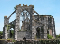
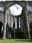
Die Abtei von Aulne (Alna) ist ein unweit von Thuin ![]() in der belgischen Provinz Hennegau im Tal der Sambre
in der belgischen Provinz Hennegau im Tal der Sambre ![]() gelegenes ehemaliges Kloster.
gelegenes ehemaliges Kloster.
Der Überlieferung nach wurde das Kloster um 656 vom später heiliggesprochenen Landelin von Crespin als Benediktinerkloster gegründet, nachdem er aus der wenige Kilometer entfernten Abtei Lobbes ![]() fortgegangen war. Er stattete das neue Kloster mit ihm von den merowingischen Frankenkönigen geschenktem Grundbesitz aus. Die Benediktiner blieben bis um 974. Nachdem sich zwischenzeitlich Augustiner-Chorherren angesiedelt hatten, wurde Aulne auf Anweisung des Bischofs Heinrich II. von Lüttich als Tochterkloster der Zisterzienser-Primarabtei Clairvaux
fortgegangen war. Er stattete das neue Kloster mit ihm von den merowingischen Frankenkönigen geschenktem Grundbesitz aus. Die Benediktiner blieben bis um 974. Nachdem sich zwischenzeitlich Augustiner-Chorherren angesiedelt hatten, wurde Aulne auf Anweisung des Bischofs Heinrich II. von Lüttich als Tochterkloster der Zisterzienser-Primarabtei Clairvaux ![]() 1147/48 unter dem Abt Franco de Morvaux neu gegründet.
1147/48 unter dem Abt Franco de Morvaux neu gegründet.
Im 15. Jahrhundert wurde es im Zug der Kriege der Burgunder gegen die Lütticher geplündert. Im 16. Jahrhundert erfolgten Überfälle der Geusen und der Franzosen. In der ersten Hälfte des 18. Jahrhunderts wurde das Kloster aufwendig erneuert und erweitert, dann aber im Zuge der Französischen Revolution um 1794 aufgelöst und niedergebrannt. Dabei wurde auch die Bibliothek mit 40.000 Büchern und 5.000 Manuskripten zerstört.
Heutiger Zustand
Erhalten ist die Ruine der Abteikirche mit einer Fassade aus dem Jahr 1728 und dem Querschiff und Chor aus dem 16. Jahrhundert. Das Abtshaus aus den Jahren 1772 bis 1778 wurde im 19. Jahrhundert, der Kapitelsaal im 18. Jahrhundert erneuert.
Informationen zu Urheber-Rechten | |
|---|---|
Rechte-Ausprägung / Lizenz | by-sa: CREATIVE COMMONS Namensnennung, Weitergabe unter gleichen Bedingungen |
Link zur Rechtebeschreibung | |
Text(e) übernommen von: |
Seite „Abtei Aulne“. In: Wikipedia, Die freie Enzyklopädie. Bearbeitungsstand: 29. September 2014, 14:55 UTC. URL: http://de.wikipedia.org/w/index.php?title=Abtei_Aulne&oldid=134462190 (Abgerufen: 1. April 2015, 21:37 UTC) |
übernommen / bearbeitet am | 01.04.2015
|
übernommen / bearbeitet durch |
|
![]()