
Ohře Cycle Route
No. of cycle route 6
Actions
![]()
Please wait - map data are loading
Added on 15 Nov 2014,
last edited by biroto-Redaktion on 19 Jan 2024
Actions
Cycle route metrics
Total distance in km
226
Information about rights to the gps-track data | |
|---|---|
Rights owner | OpenStreetMap and Contributors + biroto-Redaktion (biroto.eu) |
Rights characteristic / license | Contains information from OpenStreetMap, which is made available here under the Open Database License(ODbL) |
Link to the description of the license | |
GPX file taken from | |
GPX file uploaded | by biroto-Redaktion on 19 Jan 2024
|
Track points in total
4.021
Track points per km (avg)
18
Start/endpoint
Start location
Waldsassen, Bayern, DE (479 m NHN)
End location
Litoměřice, CZ (151 m NHN)
Signposting
| |
|


Beds4Cyclists, worth visiting and infrastructure
Name and address
Latitude / Longitude
Phone
Fax
Mobile
Type of accommodation
Rating for cyclists
Route km
Dist. to route
Elevation
0 km
4,4 km
486 m
0 km
3,9 km
477 m
Information about copyright | |
|---|---|
Rights owner | Ulrich Fech |
Rights characteristic / license | by-sa: CREATIVE COMMONS Attribution-ShareAlike |
Link to the description of the license | |
Image taken over from | |
Image has been uploaded | by biroto-Redaktion on 02 Jun 2015
|
Information about copyright | |
|---|---|
Rights owner | |
Rights characteristic / license | by-sa: CREATIVE COMMONS Attribution-ShareAlike |
Link to the description of the license | |
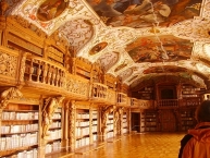
Image taken over from | commons.wikimedia.org/wiki/File:Waldsassen_Kloster_Bibliothek_1.JPG |
Image has been uploaded | by biroto-Redaktion on 02 Jun 2015
|
Information about copyright | |
|---|---|
Rights owner | |
Rights characteristic / license | by-sa: CREATIVE COMMONS Attribution-ShareAlike |
Link to the description of the license | |
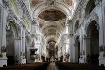
Image taken over from | commons.wikimedia.org/wiki/File:Kloster_Waldsassen_interior_1.jpg |
Image has been uploaded | by biroto-Redaktion on 02 Jun 2015
|
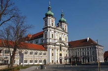
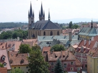
Waldsassen is a town in the district of Tirschenreuth ![]() in the Upper Palatinate region of Bavaria.
in the Upper Palatinate region of Bavaria.
The Cistercian Waldsassen Abbey was founded on 1 October 1133 by the Bavarian noble Margrave Diepold III of Vohburg. An Imperial abbey from 1214 onwards, it fell to Palatinate-Mosbach-Neumarkt branch of the House of Wittelsbach under the rule of Count Palatine Otto II in 1465.
The Palatinate rulers had the monastery dissolved in the course of the Protestant Reformation in 1571, whereafter the premises were used as tenements. Not until the 17th century new building arose in the vicinity, while after the Counter-Reformation, the abbey from 1661 onwards was resettled with Cistercian monks descending from Fürstenfeld Abbey. However, Waldsassen again was secularised during the 1803 German Mediatisation.
Part of the Kingdom of Bavaria from 1806, the local economy, mainly porcelain and glassblowing industries, was boosted by the opening of the Wiesau–Cheb railway line in 1865. Prince Regent Luitpold vested Waldsassen with city rights in 1896. The monastery again became a priory of Cistercian nuns in 1863 and again achieved the status of an independent abbey in 1925. The monastery church received the papal title of basilica minor in 1969.
Information about copyright | |
|---|---|
Rights characteristic / license | by-sa: CREATIVE COMMONS Attribution-ShareAlike |
Link to the description of the license | |
Input taken over from: |
Wikipedia contributors, 'Waldsassen', Wikipedia, The Free Encyclopedia, 20 May 2015, 00:56 UTC, <http://en.wikipedia.org/w/index.php?title=Waldsassen&oldid=663177626> [accessed 2 June 2015] |
taken over / edited on | 02 Jun 2015
|
taken over / edited by |
|
0 km
3,9 km
477 m
Hours of opening
23. März 2015 bis 30. Oktober 2015:
Montag bis Freitag von 9 bis 17 Uhr
Samstag/Sonntag/Feiertage von 10 bis 12 Uhr
31. Oktober 2015 bis März 2016:
Montag bis Freitag von 9 bis 13 Uhr
Allerheiligen, Heiligabend, 1. und 2. Weihnachtsfeiertag sowie Silvester, Neujahr und Dreikönig geschlossen.
9 km
0,4 km
Hours of opening
Monday till Friday from 9.00 till 17.00 o´clock.
Saturday and Sunday from 9.00 till 12.30 o´clock.
Languages spoken:
čeština ▪ Deutsch
9 km
0,5 km
453 m
Information about copyright | |
|---|---|
Rights owner | |
Rights characteristic / license | cc0: Public Domain no Rights reserved |
Link to the description of the license | |
Image taken over from | |
Image has been uploaded | by biroto-Redaktion on 04 Aug 2014
|
Information about copyright | |
|---|---|
Rights owner | |
Rights characteristic / license | cc0: Public Domain no Rights reserved |
Link to the description of the license | |
Image taken over from | |
Image has been uploaded | by biroto-Redaktion on 04 Aug 2014
|
Information about copyright | |
|---|---|
Rights owner | |
Rights characteristic / license | by-sa: CREATIVE COMMONS Attribution-ShareAlike |
Link to the description of the license | |
Image taken over from | |
Image has been uploaded | by biroto-Redaktion on 04 Aug 2014
|
Information about copyright | |
|---|---|
Rights owner | |
Rights characteristic / license | by-sa: CREATIVE COMMONS Attribution-ShareAlike |
Link to the description of the license | |
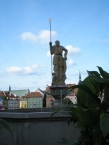
Image taken over from | commons.wikimedia.org/wiki/File:Kašna_s_Rolandem,nám.Jiřího_z_Poděbrad,Cheb.JPG |
Image has been uploaded | by biroto-Redaktion on 04 Aug 2014
|
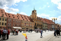
Cheb is a city in Bohemia ![]() in Western Czech Republic with a population of 33,500 and is close to the German border.
in Western Czech Republic with a population of 33,500 and is close to the German border.
Understand
The name is pronounced "khep" (the first sound like a German or Scottish "ch" or a Spanish "j" not as in "Chicken" - locals will make fun of you if you make this mistake). The city features a very quaint and pretty town square and winding alleys. However, outside of the center, the city is characterized by grimy heavy industry.
See
Museums and galleries:
- ⊙Cheb Museum. 9am-5pm, closed Sun & Mon. 20th-century paintings of Cheb. 50Kc.
- ⊙Art centrum Galerie 4 (photography gallery), Františkánské náměstí 30/1, ☎ +420 354 422838. Tu-Su: 10:00-18:00 (no entry after 17:00), closed on state holidays. (updated Nov 2017)
Buildings:
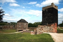
- ⊙Cheb Castle. Mostly in ruins except for its towers. Features the biggest Romanesque chapel in Bohemia. 30Kc.
On the rock, to the north-west of the city center, lies Cheb castle, built in the 12th century, and now mostly in ruins. The main attractions are the Chapel of St Erhard and Ursula, the Black Tower and the ruins of a palace; all from around 1180. The chapel has two stories; the lower storey is in Romanesque style, while the upper storey is Gothic. An eight-cornered opening connects the two storeys. The upper-storey contains a ribbed vault supported on four polygonal columns with statues depicting sins, including a statue of a prostitute and Onan. In the banquet room of this castle, Wallenstein's officers Terzky, Kinsky, Illo and Neumann were assassinated on 25 February 1634. Wallenstein himself was murdered few hours later by Captain Devereux in the burgomaster's house at the main square. The house, a 15th-century gothic town hall (Pachelbel House), was transformed in 1872, it contains many historical relics and antiquities of the town of Cheb. - ⊙Namesti Krale Jiriho z Podebrad - Main Square. 16th century former Jewish merchant houses.
On the Market Place dating from the 13th century are a group of houses originating from the late-Gothic period known as Špalíček. This distinctive feature of the market place is a bizarre complex of eleven houses. The outline of the two blocks can still be seen on the oldest existing records of 1472.
The Green House on the market place belonged to the well-known Wrendl dynasty, whose family crest lies above the entrance. Johann Wolfgang von Goethe frequently spent time here. - ⊙New Town Hall & State Gallery of the Arts. Boroque building from the 18th century. Features Czech modern art. 80Kc.
Churches:
- ⊙St. Wencelas Church.
- ⊙St. Nicolas Church. Baroque building from the 13th century.
The Church of St. Nicholas was established in the 13th century as a three-naved basilica, of which the western portal and the lower part of the tower remain in place. The three-part nave, presbytery and sacristy stem from the Gothic era. After the fire of 1742, the tower was rebuilt with a baroque cupola, after the design of the indigenous architect Balthasar Neumann. The top of the twin steeples were destroyed by German artillery fire during World War II and restored in summer 2008. - ⊙Frantiskanske Namesti. Features the St. Clare Church and the Church of the Herald of the Virgin Mary.
The Franciscan Church is located in the town center. The Church of St. Clara was built between 1708 and 1711 according to a design of Christoph Dientzenhofer.
Information about copyright | |
|---|---|
Rights characteristic / license | by-sa: CREATIVE COMMONS Attribution-ShareAlike |
Link to the description of the license | |
Input taken over from: |
|
taken over / edited on | 04 Aug 2014 - 17 Jun 2021
|
taken over / edited by |
|
![]()