
Radweg Parenzana
Aktionen
![]()
Bitte warten - Kartendaten werden geladen
Erstellt am 25.11.2019,
zuletzt geändert von biroto-Redaktion am 05.11.2023
Aktionen
Strecken-Merkmale
Gesamtlänge in km
118
Informationen zu Rechten an den GPS-Track-Daten | |
|---|---|
Rechte-Inhaber | OpenStreetMap and Contributors + biroto-Redaktion (biroto.eu) |
Rechte-Ausprägung / Lizenz | Enthält Daten von OpenStreetMap, die hier unter der Open Database License(ODbL) verfügbar gemacht werden |
Link zur Rechtebeschreibung | |
gpx-Datei übernommen aus | |
gpx-Datei hochgeladen | durch biroto-Redaktion am 05.11.2023
|
Gesamtzahl Trackpoints
2.716
Trackpoint-Dichte per km
23
Endorte
Start
Muggia, 36, IT (1 m NHN)
Ziel
Poreč, HR (1 m NHN)
Fahrradfreundliche Unterkünfte, Sehenswertes und Infrastruktur
Name u. Anschrift
Breite / Länge
Tel.
Fax.
Mobile
Art d. Unterkunft
Radler-freund-lichkeit
Strecken-km
km zur Strecke
Höhe
28 km
2,7 km
8 m
28 km
2,8 km
5 m
Informationen zu Urheber-Rechten | |
|---|---|
Rechte-Inhaber | |
Rechte-Ausprägung / Lizenz | by-sa: CREATIVE COMMONS Namensnennung, Weitergabe unter gleichen Bedingungen |
Link zur Rechtebeschreibung | |
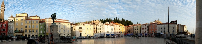
Bild übernommen aus | commons.wikimedia.org/wiki/File:Piran_Tartini-Platz_Panoramabild.jpg |
Bild hochgeladen | durch biroto-Redaktion am 21.10.2014
|
Informationen zu Urheber-Rechten | |
|---|---|
Rechte-Inhaber | |
Rechte-Ausprägung / Lizenz | by-sa: CREATIVE COMMONS Namensnennung, Weitergabe unter gleichen Bedingungen |
Link zur Rechtebeschreibung | |
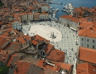
Bild übernommen aus | en.wikipedia.org/wiki/File:Tartini_Square_from_above,_Piran,_May_2009.jpg |
Bild hochgeladen | durch biroto-Redaktion am 21.10.2014
|
Informationen zu Urheber-Rechten | |
|---|---|
Rechte-Inhaber | |
Rechte-Ausprägung / Lizenz | cc0: Public Domain keine Rechte vorbehalten |
Link zur Rechtebeschreibung | |
Bild übernommen aus | |
Bild hochgeladen | durch biroto-Redaktion am 21.10.2014
|
Informationen zu Urheber-Rechten | |
|---|---|
Rechte-Inhaber | |
Rechte-Ausprägung / Lizenz | by-sa: CREATIVE COMMONS Namensnennung, Weitergabe unter gleichen Bedingungen |
Link zur Rechtebeschreibung | |
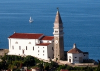
Bild übernommen aus | commons.wikimedia.org/wiki/File:Piran,_Kirche_St._Georg_mit_Baptisterium.JPG |
Bild hochgeladen | durch biroto-Redaktion am 21.10.2014
|
Piran (italienisch Pirano, deutsch veraltet: Pirian) ist eine Stadt im äußersten Südwesten Sloweniens an der Küste des Adriatischen Meeres. Mit ihrer malerischen Lage, ihrer Altstadt und venezianischen Architektur ist die Stadt an der Slowenischen Riviera eines der bekanntesten Touristenzentren Sloweniens.
Altstadt
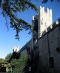
Die malerische Altstadt mit ihren engen Gassen erstreckt sich auf einer etwa einen Kilometer langen, spitz zulaufenden Landzunge in ost-westlicher Richtung. Zur Landseite hin wird sie durch eine teilweise erhaltene historische Verteidigungsanlage mit Wehrgängen und -türmen abgegrenzt.
Der Stadtkern im italienisch-venezianischen Stil wartet mit sehenswerten Baudenkmälern und eindrucksvollen Aussichtspunkten auf. Die südliche Strandpromenade, vom kleinen Hafen bis zur Spitze der Landzunge, ist gesäumt von zahlreichen exklusiven Restaurants für das touristische Publikum.
Sehenswürdigkeiten
- ⊙An der westlichen Spitze der Landzunge findet sich das burgartig wirkende Kirchlein „Sankt Clementa“ (Sv. Klementa), das als Wahrzeichen der Stadt gilt.
- ⊙Als besonderes Schmuckstück und Zentrum des städtischen Lebens wird der restaurierte Tartiniplatz (Tartinijev trg, Piazza Tartini) betrachtet. Er entstand im Jahr 1894, als der damals an dieser Stelle liegende, zu klein gewordene und als Müllkippe verwendete Hafen endgültig zugeschüttet wurde. Mitten auf dem Platz steht das Denkmal für den Komponisten Giuseppe Tartini als überlebensgroße Bronzestatue. Zu den schönsten Gebäuden des Platzes gehören das klassizistische Rathaus an der Nordseite und rechts davon ein rotes gotisches Patrizierhaus. Das "Venezianerhaus"("Benečanka") wurde von einem reichen aus Venedig stammenden und dort verheirateten Kaufmann für seine in Piran lebende Geliebte gebaut. Die Hausecke gibt das Antlitz der Geliebten wieder. Die zum Tartiniplatz gerichtete Fassade enthält ein Relief mit der italienischen Aufschrift "lassa pur dir" (Lass sie reden). (www.medievalpiran.com)
- ⊙Ca. 100 m östlich des Tartiniplatzes steht das Franziskanerkloster, das im Sommer für Konzerte genutzt wird und in dessen Untergeschoss eine Gemäldesammlung venezianischer Maler zu sehen ist.
- ⊙Auf der nördlichen Klippe der Halbinsel überragt die Sankt-Georgs-Kathedrale (Sv. Jurij) die Stadt, die 1637 errichtet wurde. Von hier aus bietet sich ein malerischer Blick über die verwinkelten Gassen und Dächer der Altstadt. Der Kirchenturm der Kathedrale ist dem venezianischen Markusturm nachempfunden. Die Kirchturmspitze schmückt eine schwerttragende Statue des Stadtpatrons Sankt Georg. Die Figur dreht sich entsprechend der Windrichtung und dient den Bürgern der Stadt somit als Wetterfahne.
- Auf dem Gebiet der Gemeinde – unmittelbar an der kroatischen Grenze – befindet sich der Naturpark Salinen von Sečovlje
 . In der Nähe des Ortsteils Strunjan findet man zudem die nördlichsten noch bewirtschafteten Salinen des Mittelmeerraums.
Museen
Am Hafen der Altstadt sind die folgenden drei Museen rund um das Thema Meer zu besichtigen:
- ⊙Das Aquarium (Kidriĉevo nabrežje 4) zeigt die Meeresfauna der Adria. Geöffnet Juni-August, täglich 9 bis 22 Uhr, sonst 9 bis 17 Uhr (www.aquariumpiran.com)
- ⊙Das Meeresmuseum ("Pomorski muzej, Cankarjevo nabrežje 3) präsentiert die wirtschaftliche Nutzung des Meeres (Fischerei, slovenische Seefahrt, Salzgewinnung). Geöffnet Juni bis September, Dienstag bis Sonntag 9 bis 12 und 17 bis 21 Uhr, sonst 9 bis 17 Uhr (www.pommuz-pi.si)
- ⊙Das Unterwassermuseum (Muzej pod vodnihdejavnosti, Župančičeva 24) zeigt Wracks und alles um das Thema Tauchen. Geöffnet Juni bis September, Dienstag bis Sonntag 10 bis 20 Uhr, sonst 11 bis 18 Uhr (www.muzejpodvodnihdejavnosti.si)
Informationen zu Urheber-Rechten | |
|---|---|
Rechte-Ausprägung / Lizenz | by-sa: CREATIVE COMMONS Namensnennung, Weitergabe unter gleichen Bedingungen |
Link zur Rechtebeschreibung | |
Text(e) übernommen von: |
Seite „Piran“. In: Wikipedia, Die freie Enzyklopädie. Bearbeitungsstand: 7. Oktober 2014, 21:30 UTC. URL: http://de.wikipedia.org/w/index.php?title=Piran&oldid=134694155 |
übernommen / bearbeitet am | 21.10.2014 - 28.11.2023
|
übernommen / bearbeitet durch |
|
49 km
0,1 km
122 m
85 km
0,5 km
271 m
85 km
0,5 km
268 m
Informationen zu Urheber-Rechten | |
|---|---|
Rechte-Inhaber | https://commons.wikimedia.org/w/index.php?title=User:Vid_Pogacnik |
Rechte-Ausprägung / Lizenz | by-sa: CREATIVE COMMONS Namensnennung, Weitergabe unter gleichen Bedingungen |
Link zur Rechtebeschreibung | |
Bild übernommen aus | |
Bild hochgeladen | durch biroto-Redaktion am 17.02.2019
|
Informationen zu Urheber-Rechten | |
|---|---|
Rechte-Inhaber | https://commons.wikimedia.org/w/index.php?title=User:Dguendel |
Rechte-Ausprägung / Lizenz | by-sa: CREATIVE COMMONS Namensnennung, Weitergabe unter gleichen Bedingungen |
Link zur Rechtebeschreibung | |
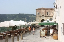
Bild übernommen aus | https://commons.wikimedia.org/wiki/File:Motovun,_the_square_"trg_Josef_Ressel",_image_2.jpg |
Bild hochgeladen | durch biroto-Redaktion am 17.02.2019
|
Informationen zu Urheber-Rechten | |
|---|---|
Rechte-Inhaber | |
Rechte-Ausprägung / Lizenz | cc0: Public Domain keine Rechte vorbehalten |
Link zur Rechtebeschreibung | |
Bild übernommen aus | https://commons.wikimedia.org/wiki/File:Motovun_–_Sveti_Stjepan_-_01.jpg |
Bild hochgeladen | durch biroto-Redaktion am 17.02.2019
|
Informationen zu Urheber-Rechten | |
|---|---|
Rechte-Inhaber | |
Rechte-Ausprägung / Lizenz | by: CREATIVE COMMONS Namensnennung |
Link zur Rechtebeschreibung | |
Bild übernommen aus | |
Bild hochgeladen | durch biroto-Redaktion am 17.02.2019
|
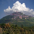
Motovun (Croatian pronunciation: [mɔtɔ̌ʋuːn], Italian: Montona or Montona d'Istria) is a village in central Istria, Croatia. The population of the village itself is 531, with a total of 983 residents in the municipality (2001); 192 of the residents speak Italian as their mother language. The Parenzana ![]() was a narrow gauge railroad that ran from Trieste
was a narrow gauge railroad that ran from Trieste ![]() to Poreč
to Poreč ![]() /Parenzo between 1902–1935, passed valley below the town.
/Parenzo between 1902–1935, passed valley below the town.
Background
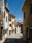
Motovun/Montona is a medieval town that grew up on the site of an ancient city called Castellieri. It is situated on a hill 270 metres (886 feet) above sea level with houses scattered all over the hill. On the inner walls are several coats-of-arms of different Motovun/Montona ruling families and two gravestones of Roman inhabitants (dating from the 1st century).
In the 10th and 11th centuries it belonged to the Bishop of Parenzo/Poreč ![]() . From 1278 it was taken over by Venice
. From 1278 it was taken over by Venice ![]() and surrounded by solid walls which are still intact today, and used as a walkway with unique views over the four corners of Istria. All three parts of the town are connected by a system of internal and external fortifications with towers and city gates containing elements of Romanesque, Gothic and Renaissance styles, built between the 14th and 17th centuries. It is a typical example of Venetian colonial architecture.
and surrounded by solid walls which are still intact today, and used as a walkway with unique views over the four corners of Istria. All three parts of the town are connected by a system of internal and external fortifications with towers and city gates containing elements of Romanesque, Gothic and Renaissance styles, built between the 14th and 17th centuries. It is a typical example of Venetian colonial architecture.
See
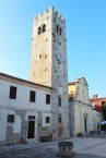
- ⊙Parish Church of St. Stephen (Sveti Stjepan)
The late-Renaissance church of St. Stephen was built right at the beginning of the 17th century according to sketches probably designed by the well-known Venetian architect Andrea Palladio (1508–1580). The church contains several works of art: the marble statues of St. Stephen and St. Laurence by Francesco Bonazzo and the 17th-century painting of the Last Supper over the altar by an unknown Venetian artist. The water cisterns in the square in front of the church date from the 14th and 15th centuries. - The forest of Motovun/Montona
The river Mirna
or Quieto river flows below the hill and on the other side of the river there is the famous Motovun/Montona forest, an area of about 10 square kilometres (4 sq mi) in the valley of the river Mirna, of which 280 hectares (690 acres) is specially protected. This area differs completely not only from the nearby forests, but also from those of the entire surrounding karst region because of its wild life, moist soil and rich-with-prized-black-and-white truffles (Tuber magnatum), which grows successfully there. Since this fungus grows underground, it is gathered with the aid of specially trained dogs.The most common tree in the forest is the English or brown oak (Quercus robur). In order to preserve natural conditions for the development of the Motovun/Montona forest, the protected area is occasionally flooded, even though the River Mirna/Quieto is controlled and its entire valley protected from flooding.
On the slopes of the hill, grapes for famous Istrian wines are grown: the Teran
and the Malvazija wine.
Informationen zu Urheber-Rechten | |
|---|---|
Rechte-Ausprägung / Lizenz | by-sa: CREATIVE COMMONS Namensnennung, Weitergabe unter gleichen Bedingungen |
Link zur Rechtebeschreibung | |
Text(e) übernommen von: |
Wikipedia contributors, 'Motovun', Wikipedia, The Free Encyclopedia, 26 July 2018, 14:31 UTC, https://en.wikipedia.org/w/index.php?title=Motovun&oldid=852084201 |
übernommen / bearbeitet am | 17.02.2019 - 19.09.2023
|
übernommen / bearbeitet durch |
|
![]()