
Cycle Route Picardie-Ardennes
No. of cycle route RV6
Actions
![]()
Please wait - map data are loading
Added on 25 Nov 2011,
last edited by biroto-Redaktion on 27 Nov 2020
Actions
Cycle route metrics
Total distance in km
330
Information about rights to the gps-track data | |
|---|---|
Rights owner | OpenStreetMap and Contributors + biroto-Redaktion (biroto.eu) |
Rights characteristic / license | Contains information from OpenStreetMap, which is made available here under the Open Database License(ODbL) |
Link to the description of the license | |
GPX file taken from | |
GPX file uploaded | by biroto-Redaktion on 27 Nov 2020
|
Track points in total
4.905
Track points per km (avg)
15
Start/endpoint
Start location
Lille, Nord-Pas-de-Calais and Picardy, FR (0 m NHN)
End location
Wiltz, LU (320 m NHN)
Beds4Cyclists, worth visiting and infrastructure
Name and address
Latitude / Longitude
Phone
Fax
Mobile
Type of accommodation
Rating for cyclists
Route km
Dist. to route
Elevation
0 km
2,6 km
24 m
0 km
2,7 km
27 m
0 km
1,2 km
25 m
Information about copyright | |
|---|---|
Rights characteristic / license | by-sa: CREATIVE COMMONS Attribution-ShareAlike |
Link to the description of the license | |
taken over / edited on | 08 Jun 2018
|
taken over / edited by |
|
0 km
2,8 km
48 m
0 km
2,1 km
49 m
Information about copyright | |
|---|---|
Rights owner | |
Rights characteristic / license | by-sa: CREATIVE COMMONS Attribution-ShareAlike |
Link to the description of the license | |
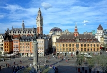
Image taken over from | https://commons.wikimedia.org/wiki/File:Lille_vue_gd_place.JPG |
Image has been uploaded | by biroto-Redaktion on 18 Oct 2017
|
Information about copyright | |
|---|---|
Rights owner | |
Rights characteristic / license | by-sa: CREATIVE COMMONS Attribution-ShareAlike |
Link to the description of the license | |
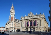
Image taken over from | https://commons.wikimedia.org/wiki/File:Lille_place_theatre_CCI_opera.jpg |
Image has been uploaded | by biroto-Redaktion on 18 Oct 2017
|
Information about copyright | |
|---|---|
Rights owner | |
Rights characteristic / license | by-sa: CREATIVE COMMONS Attribution-ShareAlike |
Link to the description of the license | |
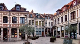
Image taken over from | https://commons.wikimedia.org/wiki/File:Lille_place_oignons_ass.jpg |
Image has been uploaded | by biroto-Redaktion on 18 Oct 2017
|
Information about copyright | |
|---|---|
Rights owner | |
Rights characteristic / license | by-sa: CREATIVE COMMONS Attribution-ShareAlike |
Link to the description of the license | |
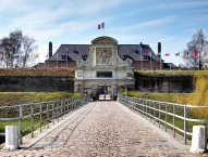
Image taken over from | https://commons.wikimedia.org/wiki/File:Lille_citadelle_entree.jpg |
Image has been uploaded | by biroto-Redaktion on 18 Oct 2017
|
Lille (Dutch: Rijsel) is a medium-sized city in the Hauts-de-France region of northern France with a very large student population. This city has a strong industrial background, but, after some difficult years, it is now known throughout France for its handsome city centre and its very active cultural life.
Understand
Lille is France's fifth largest metropolitan area. It is located to the country's north, on the Deûle River, near the border with Belgium.
See
Lille has a very nice city centre, excellently suited for a city trip. Most of the sights can be combined in a walking tour.
Must see
- ⊙La Vieille Bourse. 1653. Right between two picturesque squares, Place du Général-de-Gaulle and Place du Théâtre, this former commercial exchange still plays a central part in the life of the city. You may find booksellers and flower markets in the inner court.
- ⊙Place du Général-de-Gaulle (Grand'place). The main square of Lille. It has many lovely historic houses, like the neo-Flemish headquarters of local newspaper La Voix du Nord, and a fountain with the statue of a goddess, "la Grande Déesse" (1843).
- ⊙Place Rihour. Surrounded by restaurants, houses the tourist information centre inside its main attraction, the Palais Rihour (1453).
- ⊙Town Hall. Worth a look and can be combined nicely with a visit to the Porte de Paris (1692).
- ⊙Opera, 2 rue des Bons Enfants, ☎ +33 328 384050. Built in 1923.

- ⊙ Place du Théàtre. Built in 1921. Offers a magnificent sight, especially when lit-up at night.
- ⊙Citadelle. An interesting example of defensive military architecture, built by Vauban, a famous French military architect, under the reign of Louis the Fourteenth. In the same area is a zoo (free of charge) and a lovely park.
- ⊙Cathédrale Notre Dame de la Treille. The construction of this cathedral started in 1854 and was eventually finished only in 1999.
- Take a stroll through the old quarter of the city, known as Vieux Lille, and enjoy the quiet, cobble-stone streets, the variety of stylish designer shops and gourmet restaurants. More notable streets like ⊙Rue de la Monnaie and ⊙Rue Esquermoise are definitely worth the trip.
Museums
- ⊙Musée des Beaux-Arts, Place de la République, ☎ +33 320 067800. M: 14:00-18:00. W-Su: 10:00-18:00. Tu closed. A famed museum covering European art from 15th - 20th century. €8 regular, €4 concession (and after 4:30p for all).
- ⊙Museum of Natural History, 19 Rue de Bruxelles, ☎ +33 328 553080. A large collection of stuffed mammals, insects, fossils, etc.
- ⊙Musée de l'Hospice Comtesse, 32 Rue de la Monnaie, ☎ +33 328 368400. A former hospital now presenting art.
- ⊙Birth House of Charles de Gaulle (Maison Natale de Charles de Gaulle), 9 Rue Princesse, ☎ +33 359 730030. The birthplace of Charles de Gaulle, Leader of the French Resistance and later President of France.
Information about copyright | |
|---|---|
Rights characteristic / license | by-sa: CREATIVE COMMONS Attribution-ShareAlike |
Link to the description of the license | |
Input taken over from: |
Wikivoyage contributors, 'Lille', Wikivoyage, The FREE worldwide travel guide that anyone can edit, 14 October 2017, 15:13 UTC, <https://en.wikivoyage.org/w/index.php?title=Lille&oldid=3305058> [accessed 17 October 2017] |
taken over / edited on | 18 Oct 2017 - 12 Apr 2018
|
taken over / edited by |
|
![]()