
Cycle Route Val Müstair
No. of cycle route 27
Actions
![]()
Please wait - map data are loading
Added on 19 Oct 2016,
last edited by biroto-Redaktion on 27 Nov 2020
Actions
Cycle route metrics
Total distance in km
52
Information about rights to the gps-track data | |
|---|---|
Rights owner | OpenStreetMap and Contributors + biroto-Redaktion (biroto.eu) |
Rights characteristic / license | Contains information from OpenStreetMap, which is made available here under the Open Database License(ODbL) |
Link to the description of the license | |
GPX file taken from | |
GPX file uploaded | by biroto-Redaktion on 27 Nov 2020
|
Track points in total
1.260
Track points per km (avg)
24
Start/endpoint
Start location
Zernez, Graubünden, CH (1471 m NHN)
End location
Mals - Malles Venosta, Trentino-Alto Adige/Südtirol, IT (1035 m NHN)
Signposting
Beschilderung in der Schweiz |
|

Connecting cycle path
Verbindung über den Ofenpass zwischen
und
Beds4Cyclists, worth visiting and infrastructure
Name and address
Latitude / Longitude
Phone
Fax
Mobile
Type of accommodation
Rating for cyclists
Route km
Dist. to route
Elevation
0 km
0,3 km
1.464 m
1 km
0,0 km
1.476 m
Information about copyright | |
|---|---|
Rights owner | |
Rights characteristic / license | by-sa: CREATIVE COMMONS Attribution-ShareAlike |
Link to the description of the license | |
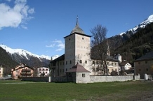
Image taken over from | commons.wikimedia.org/wiki/File:Zernez_Schloss_Wildenberg_.jpg |
Image has been uploaded | by biroto-Redaktion on 01 May 2013
|
Information about copyright | |
|---|---|
Rights owner | |
Rights characteristic / license | by-sa: CREATIVE COMMONS Attribution-ShareAlike |
Link to the description of the license | |
Image taken over from | |
Image has been uploaded | by biroto-Redaktion on 02 May 2013
|
Information about copyright | |
|---|---|
Rights owner | |
Rights characteristic / license | by-sa: CREATIVE COMMONS Attribution-ShareAlike |
Link to the description of the license | |
Image taken over from | |
Image has been uploaded | by biroto-Redaktion on 02 May 2013
|
Information about copyright | |
|---|---|
Rights owner | |
Rights characteristic / license | by-sa: CREATIVE COMMONS Attribution-ShareAlike |
Link to the description of the license | |
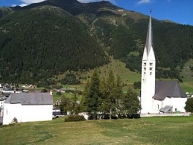
Image taken over from | commons.wikimedia.org/wiki/File:Zernez_mit_reformierter_Kirche_Zernez.JPG |
Image has been uploaded | by biroto-Redaktion on 02 May 2013
|
Zernez ist eine politische Gemeinde des Kreises Sur Tasna, Bezirk Inn des Kantons Graubünden in der Schweiz.
Sehenswürdigkeiten
- Barocke evangelische Pfarrkirche
 mit dem romanischen Turm des Vorgängerbaus.
 - Gotische reformierte Kapelle San Bastian . Nach der Reformation nicht kirchlich genutzt und ist erst seit 1952 wieder in Betrieb.
- Schloss Planta-Wildenberg , Mittelalterlicher Wohnturm mit barocken Nebengebäuden.
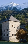
- Morenturm, Mittelalterlicher Wohnturm.
- Das neue Nationalparkhaus , Museum zum schweizerischen Nationalpark.
- Im Ortsteil Brail: mittelalterliche evangelische Kirche .
- ehemalige Talsperre von La Serra
- Fuorcha , der alte Gerichtsgalgen an der Grenze zu Susch
Information about copyright | |
|---|---|
Rights characteristic / license | by-sa: CREATIVE COMMONS Attribution-ShareAlike |
Link to the description of the license | |
Input taken over from: |
Seite „Zernez“. In: Wikipedia, Die freie Enzyklopädie. Bearbeitungsstand: 3. April 2013, 15:53 UTC. URL: http://de.wikipedia.org/w/index.php?title=Zernez&oldid=116827407 (Abgerufen: 1. Mai 2013, 21:50 UTC) |
taken over / edited on | 01 May 2013
|
taken over / edited by |
|
41 km
0,4 km
1.254 m
51 km
1,9 km
913 m
Information about copyright | |
|---|---|
Rights owner | |
Rights characteristic / license | by-sa: CREATIVE COMMONS Attribution-ShareAlike |
Link to the description of the license | |
Image taken over from | commons.wikimedia.org/wiki/File:2011-04-09_13-28-45_Italy_Trentino-Alto_Adige_Glurns.jpg |
Image has been uploaded | by biroto-Redaktion on 28 Jul 2012
|
Information about copyright | |
|---|---|
Rights owner | |
Rights characteristic / license | by: CREATIVE COMMONS Attribution |
Link to the description of the license | |
Image taken over from | |
Image has been uploaded | by biroto-Redaktion on 28 Jul 2012
|
Information about copyright | |
|---|---|
Rights owner | |
Rights characteristic / license | by-sa: CREATIVE COMMONS Attribution-ShareAlike |
Link to the description of the license | |
Image taken over from | |
Image has been uploaded | by biroto-Redaktion on 28 Jul 2012
|
Information about copyright | |
|---|---|
Rights owner | |
Rights characteristic / license | by-sa: CREATIVE COMMONS Attribution-ShareAlike |
Link to the description of the license | |
Image taken over from | |
Image has been uploaded | by biroto-Redaktion on 28 Jul 2012
|
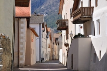
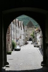
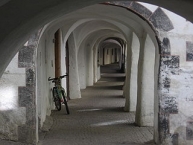
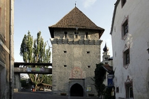
Glurns ist mit 880 Einwohnern (Stand 31. Dezember 2010) eine der kleinsten Städte der Alpen. Sie liegt im Vinschgau ![]() in der Autonomen Provinz Bozen (Südtirol). Ein besonderes Merkmal der Stadt sind ihre vollständig erhaltenen Stadtmauern. Diese trennen die Stadt in eine so genannte Inner- und eine Außerstadt.
in der Autonomen Provinz Bozen (Südtirol). Ein besonderes Merkmal der Stadt sind ihre vollständig erhaltenen Stadtmauern. Diese trennen die Stadt in eine so genannte Inner- und eine Außerstadt.
Aufgrund der überdurchschnittlich gut erhaltenen mittelalterlichen Bausubstanz, die mit dem Stadtbild von Rothenburg ob der Tauber vergleichbar ist, wird Glurns auch als das Rothenburg Südtirols genannt.
Ab den 1970er-Jahren begann unter Mitwirkung mehrerer Universitäten und Hochschulen eine umfassende Sanierung und Revitalisierung der Stadt, die nun die Vorteile des intakten malerischen Stadtbildes als Fremdenverkehrsattraktion nutzen kann.
Information about copyright | |
|---|---|
Rights characteristic / license | by-sa: CREATIVE COMMONS Attribution-ShareAlike |
Link to the description of the license | |
Input taken over from: |
Seite „Glurns“. In: Wikipedia, Die freie Enzyklopädie. Bearbeitungsstand: 21. Juni 2012, 06:41 UTC. URL: http://de.wikipedia.org/w/index.php?title=Glurns&oldid=104628314 (Abgerufen: 28. Juli 2012, 15:47 UTC) |
taken over / edited on | 28 Jul 2012
|
taken over / edited by |
|
51 km
2,0 km
908 m
![]()