Vennbahn Cycle Route
Actions
![]()
Please wait - map data are loading
Added on 15 Jun 2013,
last edited by biroto-Redaktion on 14 Jan 2021
Actions
Cycle route metrics
Total distance in km
124
Information about rights to the gps-track data | |
|---|---|
Rights owner | OpenStreetMap and Contributors + biroto-Redaktion (biroto.eu) |
Rights characteristic / license | Contains information from OpenStreetMap, which is made available here under the Open Database License(ODbL) |
Link to the description of the license | |
GPX file taken from | |
GPX file uploaded | by biroto-Redaktion on 14 Jan 2021
|
Track points in total
1.635
Track points per km (avg)
13
Start/endpoint
Start location
Aachen, Nordrhein-Westfalen, DE (170 m NHN)
End location
Ulflingen, LU (432 m NHN)
Character
Der Vennbahnradweg ist ein grenzüberschreitender Fernradweg zwischen Deutschland, Belgien und Luxemburg, der auf der Trasse der zur Zeit Preußens entstandenen ehemaligen Vennbahn über rund 130 Km von Aachen durch den Naturpark Hohes Venn-Eifel und den Ardennen nach Troisvierges (dt.: Ulflingen) verläuft. Er ist Teil des RAVeL-Netzes (frz.: Réseau Autonome de Voies Lentes), welches ein Radwegenetz in der belgischen Wallonie ist und im Oktober 1995 ins Leben gerufen wurde. Im deutsprachigem Raum erhielt der Radweg den Namen Vennbahn und ist in seiner Gesamtlänge als Premiumradweg eingestuft.
Seit Ende 2012 ist er bis auf den Abschnitt Kalterherberg-Sourbrodt zum größten Teil fertiggestellt und im Verlauf des Jahres 2013 werden sowohl dort als auch die restlichen Feinarbeiten an anderen Streckenabschnitten, wie beispielsweise zwischen Walheim und Raeren zu Ende gebracht werden. Auf den bereits fahrbereiten Abschnitten wird der Radweg von zahlreichen Radfahrern, Skatern und Wanderer angenommen und die Anrainergemeinden versprechen sich für die Zukunft eine Steigerung des lokalen Tourismus. Dies wird dadurch unterstützt, dass bereits einige ehemalige Bahnhofsgebäude zu Raststätten umgebaut worden sind, Hotels und Pensionen sich auf Tagestouristen einrichten und der öffentliche Personennahverkehr so genannte Fahrradbusse als Pendelverkehr zur Verfügung stellt. Darüber hinaus werden im Laufe des Jahres 2013 zwischen Roetgen und Kalterherberg noch sieben Stahlhäuschen im Stile eines "Verlorenen Waggons" aufgebaut, die als Wetterschutz oder Rastplatz gedacht sind.
Information about copyright | |
|---|---|
Rights characteristic / license | by-sa: CREATIVE COMMONS Attribution-ShareAlike |
Link to the description of the license | |
Input taken over from: |
Seite „Vennbahn (Radweg)“. In: Wikipedia, Die freie Enzyklopädie. Bearbeitungsstand: 11. Juni 2013, 11:54 UTC. URL: http://de.wikipedia.org/w/index.php?title=Vennbahn_(Radweg)&oldid=119444722 (Abgerufen: 15. Juni 2013, 09:47 UTC) |
taken over / edited on | 15 Jun 2013
|
taken over / edited by |
|
Signposting
|
Sources of information
Portale:
- Offizielles Portal des Vennbahnweges
- Vennbahn auf eastbelgium.com
Bücher:
- Esterbauer bikeline: Vennbahn-Radweg: Von Aachen durch den Naturpark Hohes Venn nach Luxemburg, 230 km, 1:50.000, wetterfest/reißfest
Travel reports about cycle tours
Information about copyright | |
|---|---|
Rights owner | |
Rights characteristic / license | by-sa: CREATIVE COMMONS Attribution-ShareAlike |
Link to the description of the license | |
Image has been uploaded | by ThimbleU on 23 Aug 2023
|
04 Jul 2023
58 km
A stage of the tour »Aachen - Vennbahn - Mosel - Saar - Mosel - Erft - Solingen« of user ThimbleU
Information about copyright | |
|---|---|
Rights owner | |
Rights characteristic / license | by-sa: CREATIVE COMMONS Attribution-ShareAlike |
Link to the description of the license | |
Image has been uploaded | by ThimbleU on 22 Aug 2023
|
05 Jul 2023
100 km
A stage of the tour »Aachen - Vennbahn - Mosel - Saar - Mosel - Erft - Solingen« of user ThimbleU
Beds4Cyclists, worth visiting and infrastructure
Name and address
Latitude / Longitude
Phone
Fax
Mobile
Type of accommodation
Rating for cyclists
Route km
Dist. to route
Elevation
0 km
1,7 km
176 m
Information about copyright | |
|---|---|
Rights owner | |
Rights characteristic / license | cc0: Public Domain no Rights reserved |
Link to the description of the license | |
Image taken over from | commons.wikimedia.org/wiki/File:2007-05-01_11-40_Aachen_1-250_sec_F4_38mm_-001.JPG |
Image has been uploaded | by biroto-Redaktion on 06 Apr 2015
|
Information about copyright | |
|---|---|
Rights owner | |
Rights characteristic / license | by-sa: CREATIVE COMMONS Attribution-ShareAlike |
Link to the description of the license | |
Image taken over from | commons.wikimedia.org/wiki/File:Aachen,_Elisenbrunnen,_2011-07_CN-01.jpg |
Image has been uploaded | by biroto-Redaktion on 06 Apr 2015
|
Information about copyright | |
|---|---|
Rights owner | |
Rights characteristic / license | by-sa: CREATIVE COMMONS Attribution-ShareAlike |
Link to the description of the license | |
Image taken over from | |
Image has been uploaded | by biroto-Redaktion on 06 Apr 2015
|
Information about copyright | |
|---|---|
Rights owner | |
Rights characteristic / license | by-sa: CREATIVE COMMONS Attribution-ShareAlike |
Link to the description of the license | |
Image taken over from | commons.wikimedia.org/wiki/File:Aachen,_Mitte,_Couven-Museum,_2011-08_CN-01.jpg |
Image has been uploaded | by biroto-Redaktion on 06 Apr 2015
|
Aachen (German pronunciation: [ˈʔaːxən]) is a historically important city, spa and university centre in North Rhine-Westphalia, situated at the "three lands corner" where the borders of Germany, Belgium and the Netherlands meet. Known as Aix-la-Chapelle in French and Aken in Dutch, the city has played a prominent role in early Medieval Europe, when it became the favoured residence of Charlemagne, the first Holy Roman Emperor who created the empire in the late 8th and early 9th century and built the city's impressive cathedral, where he is now buried along with a succession of later German rulers, many of whom were also crowned in the city.
Apart from its medieval significance and a wealth of preserved artifacts, Aachen is also known for its springs, which have been attracting visitors since the Ancient Roman times and continue to do so today, with a number of historic baths and hotels sprinkled around the city. Contributing to the city's wealth and prominence is also the technical university, which made Aachen a hub for modern technologies and provides a sizeable student population (over 40 000 of the total 250 000 inhabitants). With all this, Aachen is now a multi-cultural, popular tourist destination.
Historically this spa-town was a prominent city, the place where the German Kings were crowned, and a famously favoured residence of Charlemagne who still lies buried in the impressive cathedral he himself had built. The city is packed with historic sights that remind of those days, including medieval buildings, city gates and beautiful fountains.
Understand
Aachen was the preferred residence of Charlemagne, "Roman" Emperor from 800 to 814 AD and king of an empire covering much of modern day Italy, France, Germany and the Benelux. Additional information can be found at the Route Charlemagne Aachen website.
As Aachen is a legally recognised spa, it could technically call itself Bad Aachen, but refuses to do so, as it then wouldn't be listed first in almost all alphabetical lists.
The city lies at the borders of Germany with Belgium and the Netherlands, forming the economic region called the Euregio. There are several Euregios in Europe, but regionally speaking just of "the Euregio" is understood to mean the one centered on Aachen.
See
- ⊙Aachen Cathedral
 , Domhof 1, ☎ +49 241 477090. Opening times of the Cathedral: Jan-Mar: Daily 7AM-6PM, Apr-Dec: Daily 7AM-7PM. Note that during mass access is restricted to attending in the services. Touristic visits are recommended for Mon-Fri after 11AM; Sat-Sun after 12:30 PM. Aachen Cathedral is one of the most famous examples of occidental architecture. Around 800, the core building of the Palace Chapel was built. During the 14th and 15th centuries, the Gothic choir (the "Aachen glasshouse"), the north and south chapel were added. Through the centuries, many other constructions and decorations were completed. Today, it is a unique and beautiful two-storey cathedral of classical pillars, bronze railings, golden masterpieces, glassworks, etc.
The cathedral is the memorial and funeral place of Charlemagne (+814). During 936-1531, 30 kings and 12 queens were anointed, crowned and enthroned here. In the Middle Ages, it was one of Christendom's most important venues for pilgrimage, together with Jerusalem, Rome and Santiago de Compostela. Heiligtumsfahrt (the Aachen pilgrimage) takes place every year since 1349 (the next one will be in June 2014). In 1978 it was the first German building to be inscribed as a UNESCO World Heritage Site. - ⊙Cathedral Treasury (Domschatzkammer), Johannes-Paul-II.-Straße. Opening times of the treasure grove (Schatzkammer): Jan-Mar: M 10AM-1PM; Tu-Su 10AM-5PM. Apr-Dec: M 10AM-1PM; Tu-Su 10AM-6PM; closed on 24 and 25 Dec, 31 Dec, 01 Jan, and some days around carnival. Ecclesiastical treasures from Antique, Carolingian, Ottonian and Staufian epochs,including Cross of Lothair and the Bust of Charlemagne.
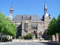
- ⊙Rathaus, Markt, ☎ +49 241 4320. The city hall
, dated from 1330, lies between two central places, the Markt (market place) and the Katschhof (between city hall and cathedral). The coronation hall is on the first floor of the building. Inside you can find five frescoes by the Aachen artist Alfred Rethel which show legendary scenes from the life of Charlemagne, as well as Charlemagne's signature. It also contains the hall of the emperors, along with replicas of the imperial crown jewels.
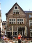
- ⊙ The Grashaus, a late medieval house at the Fisch Markt, is one of the oldest non-religious buildings in downtown Aachen. It hosted the city archive. The Grashaus was the former city hall before the present building took over this function.
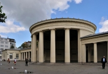
- The ⊙Elisenbrunnen is one of the most famous sights of Aachen. It is a neo-classical hall covering one of the city's famous fountains. It is just a minute away from the cathedral.
- Also of note are two remaining city gates, the ⊙Ponttor
, one half-mile northwest of the cathedral, and the ⊙Kleinmarschiertor, close to the central railway station. There are also a few parts of both medieval city walls left, most of them integrated into more recent buildings, but some others still visible. There are even five towers left, some of which are used for housing.
- St. Michael's Church
was built as a church of the Aachen Jesuit Collegium in 1628. It is attributed to the Rhine mannerism and a sample of a local Renaissance-architecture. The rich façade remained unfinished until 1891 when the historistic architect Peter Friedrich Peters added to it. The church is a Greek Orthodox church today, but the building is used also for concerts because of its good acoustics.
- The Jewish synagogue in Aachen which was destroyed at the Night of Broken Glass (Kristallnacht) on 9 November 1938, was reinaugurated on 18 May 1995.
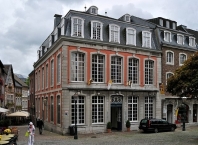
- There are numerous other notable churches and monasteries, a few remarkable 17th- and 18th-century buildings in the particular Baroque style typical of the region, a Jewish synagogue, a collection of statues and monuments, park areas, cemeteries, among others.
- Among the museums in the town are the ⊙Suermondt-Ludwig Museum
, which has a fine sculpture collection and the ⊙ Aachen Museum of the International Press, which is dedicated to newspapers from the 16th century to the present.
- The area's industrial history is reflected in dozens of 19th- and early 20th-century manufacturing sites in the city.
Eat
Aachen offers many different cuisines, from traditional German food to exotic cuisines. The centre offers restaurants of all categories, prices being relatively cheap in comparison with other German cities. Students prefer the snack bars and light meals offered at Pontstraße.
- ⊙Goldener Schwan, Markt 37 (Opposite Rathaus), ☎ +49 241 31649. 15th century building where you can now get local and German meals. For example Aachener Puttes a type of Blutwurst similar to English black pudding.
Information about copyright | |
|---|---|
Rights characteristic / license | by-sa: CREATIVE COMMONS Attribution-ShareAlike |
Link to the description of the license | |
Input taken over from: |
|
taken over / edited on | 06 Apr 2015 - 22 May 2021
|
taken over / edited by |
|
0 km
1,5 km
177 m
0 km
1,3 km
180 m
0 km
1,3 km
170 m
0 km
2,8 km
147 m
Information about copyright | |
|---|---|
Rights owner | |
Rights characteristic / license | by: CREATIVE COMMONS Attribution |
Link to the description of the license | |
Image taken over from | |
Image has been uploaded | by ThimbleU on 29 Dec 2013
|
Information about copyright | |
|---|---|
Rights owner | |
Rights characteristic / license | by-sa: CREATIVE COMMONS Attribution-ShareAlike |
Link to the description of the license | |
Image taken over from | commons.wikimedia.org/wiki/File:Aachen,_Neuer_Tivoli,_innen.jpg |
Image has been uploaded | by ThimbleU on 29 Dec 2013
|
Information about copyright | |
|---|---|
Rights owner | |
Rights characteristic / license | by-sa: CREATIVE COMMONS Attribution-ShareAlike |
Link to the description of the license | |
Image taken over from | |
Image has been uploaded | by ThimbleU on 29 Dec 2013
|
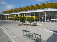
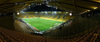
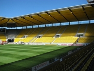
The New Tivoli is a football stadium in the Sport Park Soers in Aachen
, Germany, that opened on 17 August 2009 replacing the Old Tivoli nearby. It hosts the home matches of Alemannia Aachen in the 3. Liga. The stadium has a capacity of 32,960 spectators – space for 11,681 standing spectators and 19,345 seats. The (all-)seating capacity for international games is set at 27,250.
The city first suggested the new stadium should be built outside the city, near the local airport. However, fans wanted the stadium built within the city. After much debate, plans were released in February 2007, showing that the new stadium would be built in Sportpark Soers, the sporting area the previous stadium was in.
About € 4.2 million of the construction costs were financed by bonds mainly targeted at supporters of Alemannia Aachen.
The first match in the new stadium was against the Belgium team Lierse SK, but it was closed for the public. The first Bundesliga-match took place on 17 August 2009 against FC St. Pauli which Aachen lost 0–5, which was the highest home-defeat in Aachen's history.
The first international match was on 4 September 2009 when the Germany national under-21 football team played their first match of the 2011 UEFA European Under-21 Football Championship qualification against San Marino.
Information about copyright | |
|---|---|
Rights characteristic / license | by-sa: CREATIVE COMMONS Attribution-ShareAlike |
Link to the description of the license | |
Input taken over from: |
Wikipedia contributors, 'New Tivoli', Wikipedia, The Free Encyclopedia, 17 November 2013, 18:26 UTC, http://en.wikipedia.org/w/index.php?title=New_Tivoli&oldid=582081535 [accessed 29 December 2013] |
taken over / edited on | 29 Dec 2013 - 30 Dec 2013
|
taken over / edited by |
|
![]()


