
Cycle Route Coeur de France à vélo
No. of cycle route V46
Actions
![]()
Please wait - map data are loading
Added on 21 May 2021,
on 21 May 2021
Actions
Cycle route metrics
Total distance in km
51
Information about rights to the gps-track data | |
|---|---|
Rights owner | OpenStreetMap and Contributors + biroto-Redaktion (biroto.eu) |
Rights characteristic / license | Contains information from OpenStreetMap, which is made available here under the Open Database License(ODbL) |
Link to the description of the license | |
GPX file taken from | |
GPX file uploaded | by biroto-Redaktion on 21 May 2021
|
Track points in total
629
Track points per km (avg)
12
Start/endpoint
Start location
Saint-Amand-Montrond, Centre-Loire Valley, FR (160 m NHN)
End location
Montluçon, Auvergne-Rhône-Alpes, FR (202 m NHN)
Beds4Cyclists, worth visiting and infrastructure
Name and address
Latitude / Longitude
Phone
Fax
Mobile
Type of accommodation
Rating for cyclists
Route km
Dist. to route
Elevation
2 km
0,5 km
159 m
Hours of opening
from Monday to Saturday from 09:00 - 12:00 and from 13:30 - 17:30
2 km
0,4 km
168 m
2 km
0,7 km
157 m
2 km
0,5 km
165 m
3 km
3,8 km
147 m
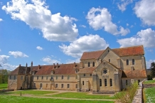
Das Kloster Noirlac (Nerlac; La Maison-Dieu; Niger lacus) ist eine ehemalige Zisterzienserabtei in der Gemeinde Bruère-Allichamps ![]() bei Saint-Amand-Montrond
bei Saint-Amand-Montrond ![]() im Département Cher, Region Centre-Val de Loire, in Frankreich. Es liegt rund 40 km südlich von Bourges am rechten Ufer des Flusses Cher nahe einer Römerstraße.
im Département Cher, Region Centre-Val de Loire, in Frankreich. Es liegt rund 40 km südlich von Bourges am rechten Ufer des Flusses Cher nahe einer Römerstraße.
Geschichte
Das Kloster wurde dank einer Stiftung von Ebbe V, dem Herrn von Charenton, 1136 gegründet und von einem Gründungskonvent unter Robert, wohl dem Vetter von Bernhard von Clairvaux, besiedelt. Es befand sich zunächst in La Celle ![]() , wurde aber bald an seinen jetzigen Ort am Rand des Walds von Meillant (Forêt de Meilland) verlegt. Die Neugründung wurde vom Erzbischof von Bourges, Pierre de la Châtre, im Jahr 1159 bestätigt. Im gleichen Jahr wurde dem Kloster die Zisterzienserinnenabtei Kloster Bussières
, wurde aber bald an seinen jetzigen Ort am Rand des Walds von Meillant (Forêt de Meilland) verlegt. Die Neugründung wurde vom Erzbischof von Bourges, Pierre de la Châtre, im Jahr 1159 bestätigt. Im gleichen Jahr wurde dem Kloster die Zisterzienserinnenabtei Kloster Bussières ![]() unterstellt. 1175 wurde die Gemeinschaft durch eine Epidemie dezimiert. In der zweiten Hälfte des 12. Jahrhunderts erhielt das Kloster bedeutende Zuwendungen. Seit 1276 verdrängte der Name Noirlac den früheren Maison-Dieu. 1277 setzte das Generalkapitel den Abt ab. Während des Hundertjährigen Kriegs wurde die Abtei von den Grandes Compagnies verheert, was zu seiner Befestigung führte. Mangelnde Disziplin führte 1506 zu einer Visitation durch die Äbte der Klöster Reigny, Fontmorigny und Chalivoy. 1510 fiel das Kloster in Kommende. 1562 oder bei Auseinandersetzungen in der Mitte des 17. Jahrhunderts (Fronde gegen die Familie de Condé) wurde es von den Hugenotten eingenommen, dabei erlitt es erheblichen Schaden. 1654 lebten nurmehr vier Mönche in Noirlac. Im 17. und 18. Jahrhundert wurden Instandsetzungsarbeiten durchgeführt. In der Französischen Revolution wurde die Abtei als Nationalgut eingezogen und anschließend verkauft. In seinen Räumen wurde 1822 eine Porzellanfabrik eingerichtet. In die Kirche kamen Brennöfen. Seit 1862 ist die Abtei als Monument historique klassifiziert. 1890 kam ein Waisenhaus in das Kloster, anschließend eine Gruppe von Nonnen, die 1901 aufgelöst wurde. Nach 1910 wurde es vom Département Cher aufgekauft, das Restaurierungsmaßnahmen einleitete. Im spanischen Bürgerkrieg diente das Kloster als Flüchtlingslager und anschließend wurden die Insassen des Altersheims von Saint-Amand in ihm untergebracht. Ab 1949 erfolgte eine umfassende Restaurierung.
unterstellt. 1175 wurde die Gemeinschaft durch eine Epidemie dezimiert. In der zweiten Hälfte des 12. Jahrhunderts erhielt das Kloster bedeutende Zuwendungen. Seit 1276 verdrängte der Name Noirlac den früheren Maison-Dieu. 1277 setzte das Generalkapitel den Abt ab. Während des Hundertjährigen Kriegs wurde die Abtei von den Grandes Compagnies verheert, was zu seiner Befestigung führte. Mangelnde Disziplin führte 1506 zu einer Visitation durch die Äbte der Klöster Reigny, Fontmorigny und Chalivoy. 1510 fiel das Kloster in Kommende. 1562 oder bei Auseinandersetzungen in der Mitte des 17. Jahrhunderts (Fronde gegen die Familie de Condé) wurde es von den Hugenotten eingenommen, dabei erlitt es erheblichen Schaden. 1654 lebten nurmehr vier Mönche in Noirlac. Im 17. und 18. Jahrhundert wurden Instandsetzungsarbeiten durchgeführt. In der Französischen Revolution wurde die Abtei als Nationalgut eingezogen und anschließend verkauft. In seinen Räumen wurde 1822 eine Porzellanfabrik eingerichtet. In die Kirche kamen Brennöfen. Seit 1862 ist die Abtei als Monument historique klassifiziert. 1890 kam ein Waisenhaus in das Kloster, anschließend eine Gruppe von Nonnen, die 1901 aufgelöst wurde. Nach 1910 wurde es vom Département Cher aufgekauft, das Restaurierungsmaßnahmen einleitete. Im spanischen Bürgerkrieg diente das Kloster als Flüchtlingslager und anschließend wurden die Insassen des Altersheims von Saint-Amand in ihm untergebracht. Ab 1949 erfolgte eine umfassende Restaurierung.
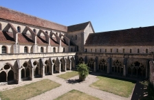
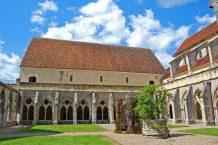
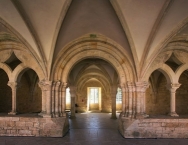
Bauten und Anlage
Die Kirche ist eine dreischiffige Basilika von 59 m Länge mit acht Langhausjochen, einem wenig ausladenden Querhaus mit je zwei Seitenkapellen im Osten und einem gerade geschlossenen, spitztonnengewölbten Chor mit drei Lanzettfenstern und einem von einer auf zwei Säulen aufliegenden Archivolte eingefassten Rundfenster darüber. Der spitzbogige Triumphbogen stützt sich auf zwei Pilaster. Über ihm liegt ein spitzbogiges Fenster. Das Kreuzrippengewölbe des Querhauses ist wesentlich höher als das Chorgewölbe. Der Glockenturm über der Vierung ist abgegangen. Die Ostteile stammen noch aus der Zeit um 1150 bis 1160. Vom südlichen Querschiffarm führt die Treppe zum Dormitorium. Das kreuzrippengewölbte Mittelschiff ist von den Seitenschiffen durch spitzbogige Arkaden getrennt. Über den Arkanden liegen spitzbogige Fenster. Die Fassade aus dem 13. Jahrhundert weist eine sechsteilige Fensterrose auf. Die Vorhalle ist nicht mehr vorhanden. Der südlich (rechts) von der Kirche gelegene, reich dekorierte Kreuzgang aus dem 13. und 14. Jahrhundert ist mit seinen Gewölben auf drei Seiten erhalten; die Gewölbe der Südseite sind eingestürzt. Auf der Ostseite des Kreuzgangs liegen die Sakristei, von deren ursprünglich drei Jochen zwei erhalten sind. Der Kapitelsaal aus sechs quadratischen, rippengewölbten Jochen hat einen rundbogigen Eingang vom Kreuzgang, der von zwei Fensteröffnungen flankiert wird. Der südlich gelegene Mönchssaal wird von acht Kreuzgratgewölben überspannt. Das Dormitorium im Obergeschoss, ist im 17. und 18. Jahrhundert umgebaut worden. Auf der Südseite des Kreuzgangs liegt das Refektorium, das ein unregelmäßiges zweischiffiges mit acht Jochen Rechteck bildet. Vom Konversenhaus ist nur der nördliche Teil mit einem zehnjochigen, kreuzgratgewölbten Raum erhalten. Östlich und südlich schließen sich an die Abtei Gartenanlagen an.
Information about copyright | |
|---|---|
Rights characteristic / license | by-sa: CREATIVE COMMONS Attribution-ShareAlike |
Link to the description of the license | |
Input taken over from: |
Seite „Kloster Noirlac“. In: Wikipedia, Die freie Enzyklopädie. Bearbeitungsstand: 21. Juni 2019, 08:21 UTC. URL: https://de.wikipedia.org/w/index.php?title=Kloster_Noirlac&oldid=189734638 (Abgerufen: 24. April 2020, 10:22 UTC) |
taken over / edited on | 24 Apr 2020
|
taken over / edited by |
|
![]()