
Cycle Route Von der Loire an die Garonne
No. of cycle route V87
Actions
![]()
Please wait - map data are loading
Added on 16 Nov 2016,
last edited by biroto-Redaktion on 06 Dec 2020
Actions
Cycle route metrics
Total distance in km
332
Information about rights to the gps-track data | |
|---|---|
Rights owner | OpenStreetMap and Contributors + biroto-Redaktion (biroto.eu) |
Rights characteristic / license | Contains information from OpenStreetMap, which is made available here under the Open Database License(ODbL) |
Link to the description of the license | |
GPX file taken from | |
GPX file uploaded | by biroto-Redaktion on 06 Dec 2020
|
Track points in total
7.195
Track points per km (avg)
22
Start/endpoint
Start location
Montluçon, Auvergne-Rhône-Alpes, FR (200 m NHN)
End location
Saint-Sozy, Occitania, FR (107 m NHN)
Beds4Cyclists, worth visiting and infrastructure
Name and address
Latitude / Longitude
Phone
Fax
Mobile
Type of accommodation
Rating for cyclists
Route km
Dist. to route
Elevation
1 km
0,6 km
214 m
Information about copyright | |
|---|---|
Rights owner | |
Rights characteristic / license | by-sa: CREATIVE COMMONS Attribution-ShareAlike |
Link to the description of the license | |
Image taken over from | |
Image has been uploaded | by biroto-Redaktion on 06 Dec 2020
|
Information about copyright | |
|---|---|
Rights owner | |
Rights characteristic / license | by-sa: CREATIVE COMMONS Attribution-ShareAlike |
Link to the description of the license | |
Image taken over from | https://commons.wikimedia.org/wiki/File:Maison_des_douze_apôtres_à_Montluçon_en_juillet_2014_-_1.jpg |
Image has been uploaded | by biroto-Redaktion on 06 Dec 2020
|
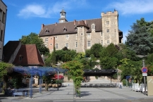
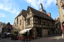
Montluçon ist eine französische Stadt in der Region Auvergne-Rhône-Alpes. Mit 35.653 Einwohnern (Stand 2017) ist sie die größte Stadt im Département Allier. Montluçon liegt im Zentrum Frankreichs an einer Flussbiegung des oberen Cher ![]() und ist Endpunkt des aufgelassenen Canal de Berry
und ist Endpunkt des aufgelassenen Canal de Berry ![]() .
.
Sehenswürdigkeiten
- Altstadt
- ⊙Kirche St-Pierre: 12./13. Jahrhundert, romanisch, einschiffig, von vier Rundsäulen getragener Vierungsturm; Taufbecken und Statue der Maria Magdalena aus dem 15. Jahrhundert, die Kirche liegt im Norden der Altstadt
- ⊙Kirche Notre-Dame: romanisch-gotisch
- ⊙Château des Ducs de Bourbon (Schloss der Bourbonen-Herzöge): auf dem Mont Luçon, einem Granithügel über der Stadt, ab Mitte des 13. Jahrhunderts im Fachwerkstil errichtet
- ⊙Musée/Château de la Louvière: ab 1926 im Stil des Ancien Régime, inmitten eines größeren Parks in italienisch-englischem Stil errichtet
Information about copyright | |
|---|---|
Rights characteristic / license | by-sa: CREATIVE COMMONS Attribution-ShareAlike |
Link to the description of the license | |
Input taken over from: |
Seite „Montluçon“. In: Wikipedia, Die freie Enzyklopädie. Bearbeitungsstand: 16. Mai 2020, 00:38 UTC. URL: https://de.wikipedia.org/w/index.php?title=Montlu%C3%A7on&oldid=199995017 (Abgerufen: 6. Dezember 2020, 16:29 UTC) |
taken over / edited on | 06 Dec 2020
|
taken over / edited by |
|
1 km
0,6 km
214 m
Hours of opening
from 1st June to the Heritage Days weekend (3rd weekend of September)
from Monday to Saturday:
09:30 - 12:30 and 13:30 - 19:00
on Sundays and public holidays in July and August and on the Sunday of the Heritage Days
09:30 - 13:00
outside the period
from Monday to Saturday:
10:00 - 12:00 and 14:00 - 18:00
1 km
0,4 km
217 m
3 km
1,4 km
234 m
109 km
0,3 km
535 m
![]()