
Cycle Route Via Allier
No. of cycle route V70
Actions
![]()
Please wait - map data are loading
Added on 30 Jul 2016,
last edited by biroto-Redaktion on 23 Sep 2023
Actions
Cycle route metrics
Total distance in km
453
Information about rights to the gps-track data | |
|---|---|
Rights owner | OpenStreetMap and Contributors + biroto-Redaktion (biroto.eu) |
Rights characteristic / license | Contains information from OpenStreetMap, which is made available here under the Open Database License(ODbL) |
Link to the description of the license | |
GPX file taken from | |
GPX file uploaded | by biroto-Redaktion on 22 Sep 2023
|
Track points in total
8.453
Track points per km (avg)
19
Start/endpoint
Start location
Nevers, BFC, FR (195 m NHN)
End location
Langogne, OCC, FR (912 m NHN)
Signposting
|
|

Beds4Cyclists, worth visiting and infrastructure
Name and address
Latitude / Longitude
Phone
Fax
Mobile
Type of accommodation
Rating for cyclists
Route km
Dist. to route
Elevation
0 km
0,0 km
202 m
Information about copyright | |
|---|---|
Rights owner | |
Rights characteristic / license | by-sa: CREATIVE COMMONS Attribution-ShareAlike |
Link to the description of the license | |
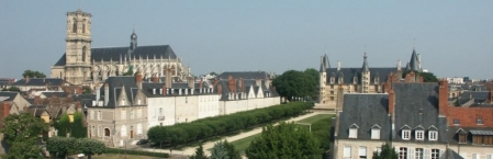
Image taken over from | commons.wikimedia.org/wiki/File:Palais_Ducal_et_Cathédrale_de_la_Ville_de_Nevers.jpg |
Image has been uploaded | by biroto-Redaktion on 12 Mar 2014
|
Information about copyright | |
|---|---|
Rights owner | |
Rights characteristic / license | by-sa: CREATIVE COMMONS Attribution-ShareAlike |
Link to the description of the license | |
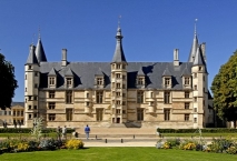
Image taken over from | commons.wikimedia.org/wiki/File:F06.Nevers.Palais_Ducal.1161.JPG |
Image has been uploaded | by biroto-Redaktion on 12 Mar 2014
|
Information about copyright | |
|---|---|
Rights owner | |
Rights characteristic / license | by-sa: CREATIVE COMMONS Attribution-ShareAlike |
Link to the description of the license | |
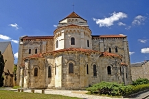
Image taken over from | commons.wikimedia.org/wiki/File:F06.Nevers_St.-Etienne.1068.JPG |
Image has been uploaded | by biroto-Redaktion on 12 Mar 2014
|
Information about copyright | |
|---|---|
Rights owner | |
Rights characteristic / license | by-sa: CREATIVE COMMONS Attribution-ShareAlike |
Link to the description of the license | |
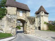
Image taken over from | commons.wikimedia.org/wiki/File:094_Nevers_Porte_du_Croux_Les_remparts.jpg |
Image has been uploaded | by biroto-Redaktion on 12 Mar 2014
|
Nevers (French pronunciation: [nəˈvɛʀ]; Latin: Noviodunum, later Nevirnum and Nebirnum) is a commune in – and the administrative capital of – the Nièvre department in the Bourgogne region in central France.
Main sights
Narrow winding streets lead from the quay through the town where there are numerous old houses of the 14th to the 17th centuries.
Among the ecclesiastical buildings the most important is the ⊙Cathédrale of Saint Cyr-Sainte Julitte ![]() , dedicated to Saint Quiricus and Saint Julietta, which is a combination of two buildings, and possesses two apses. The apse and transept at the west end are the remains of a Romanesque church, while the nave and eastern apse are in the Gothic style and belong to the 14th century. There is no transept at the eastern end. The lateral portal on the south side belongs to the late 15th century; the massive and elaborately decorated tower which rises beside it to the early 16th century.
, dedicated to Saint Quiricus and Saint Julietta, which is a combination of two buildings, and possesses two apses. The apse and transept at the west end are the remains of a Romanesque church, while the nave and eastern apse are in the Gothic style and belong to the 14th century. There is no transept at the eastern end. The lateral portal on the south side belongs to the late 15th century; the massive and elaborately decorated tower which rises beside it to the early 16th century.
The church of ⊙Saint Etienne is a specimen of the Romanesque style of Auvergne of which the disposition of the apse with its three radiating chapels is characteristic. It was consecrated at the close of the 9th century, and belonged to a priory affiliated to Cluny.
The ⊙Ducal Palace ![]() (now occupied by the courts of justice and an important ceramic museum) was built in the 15th and 16th centuries and is one of the principal feudal edifices in central France. The façade is flanked at each end by a turret and a round tower. A middle tower containing the great staircase has its windows adorned by sculptures relating to the history of the House of La Marck
(now occupied by the courts of justice and an important ceramic museum) was built in the 15th and 16th centuries and is one of the principal feudal edifices in central France. The façade is flanked at each end by a turret and a round tower. A middle tower containing the great staircase has its windows adorned by sculptures relating to the history of the House of La Marck ![]() by the members of which the greater part of the palace was built.
by the members of which the greater part of the palace was built.
In front of the palace lies an open space with a fine view over the valley of the Loire. The ⊙Porte du Croux, a square tower, with corner turrets, dating from the end of the 14th century, is among the remnants of the old fortifications; it now contains a collection of sculptures and Roman antiquities.
A triumphal arch from the 18th century, commemorating the victory of Fontenoyand the hotel de ville, a modern building which contains the library, are of some interest. The Loire is crossed by a modern stone bridge, and by an iron railway bridge.
At the ⊙Chapel of Saint Bernadette at the mother house of the Sisters of Charity of Nevers, it is possible to view the incorrupt remains of Bernadette Soubirous (Saint Bernadette) which are presented in a gold and crystal reliquary.
Information about copyright | |
|---|---|
Rights characteristic / license | by-sa: CREATIVE COMMONS Attribution-ShareAlike |
Link to the description of the license | |
Input taken over from: |
Wikipedia contributors, 'Nevers', Wikipedia, The Free Encyclopedia, 20 December 2013, 23:17 UTC, http://en.wikipedia.org/w/index.php?title=Nevers&oldid=587024386 |
taken over / edited on | 12 Mar 2014 - 22 Sep 2023
|
taken over / edited by |
|
0 km
0,0 km
197 m
Hours of opening
Low season: October to May
Open Monday to Saturday from 10h to 12h30 / 14h to 18h
Closed Sunday and Monday morning from October to April
Holidays in April and May: 10h-13h / 14h-18h including May 1st
High Season: June to September
Open Monday to Saturday from 9:30 a.m. to 6:30 p.m.
Sunday and holidays: 10h-13h / 14h-18h
0 km
0,4 km
205 m
1 km
0,5 km
170 m
2 km
0,0 km
183 m
![]()