
Cycle Route La Flow Vélo - From the Dordogne to the mouth of the Charente
No. of cycle route V92
Actions
![]()
Please wait - map data are loading
Added on 27 Feb 2018,
on 05 Nov 2023
Actions
Cycle route metrics
Total distance in km
391
Information about rights to the gps-track data | |
|---|---|
Rights owner | OpenStreetMap and Contributors + biroto-Redaktion (biroto.eu) |
Rights characteristic / license | Contains information from OpenStreetMap, which is made available here under the Open Database License(ODbL) |
Link to the description of the license | |
GPX file taken from | |
GPX file uploaded | by biroto-Redaktion on 05 Nov 2023
|
Track points in total
6.822
Track points per km (avg)
17
Start/endpoint
Start location
Sarlat-la-Canéda, NAQ, FR (129 m NHN)
End location
Île-d'Aix, NAQ, FR (2 m NHN)
Signposting
|

Beds4Cyclists, worth visiting and infrastructure
Name and address
Latitude / Longitude
Phone
Fax
Mobile
Type of accommodation
Rating for cyclists
Route km
Dist. to route
Elevation
4 km
0,1 km
146 m
5 km
0,1 km
144 m
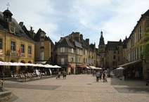
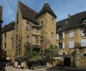
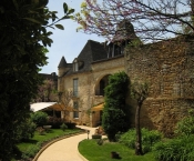
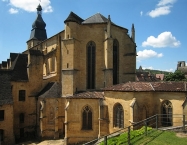
Sarlat-la-Canéda (French: [saʁ.la.la.ka.ne.da] ; Occitan: Sarlat e La Canedat), or simply Sarlat, is a commune in the Dordogne department in Aquitaine in southwestern France.
Sarlat is a medieval town that developed around a large Benedictine ![]() abbey
abbey ![]() of Carolingian
of Carolingian ![]() origin. The medieval Sarlat Cathedral
origin. The medieval Sarlat Cathedral ![]() is dedicated to Saint Sacerdos
is dedicated to Saint Sacerdos ![]() .
.
Because modern history has largely passed it by, Sarlat has remained preserved and one of the towns most representative of 14th century France. It owes its current status on France's Tentative List for future nomination as a UNESCO World Heritage site to the enthusiasm of writer, resistance fighter and politician André Malraux ![]() , who, as Minister of Culture (1960–1969), restored the town and many other sites of historic significance throughout France. The centre of the old town consists of impeccably restored stone buildings and is largely car-free.
, who, as Minister of Culture (1960–1969), restored the town and many other sites of historic significance throughout France. The centre of the old town consists of impeccably restored stone buildings and is largely car-free.
Information about copyright | |
|---|---|
Rights characteristic / license | by-sa: CREATIVE COMMONS Attribution-ShareAlike |
Link to the description of the license | |
Input taken over from: |
Wikipedia contributors, 'Sarlat-la-Canéda', Wikipedia, The Free Encyclopedia, 11 March 2015, 10:22 UTC, <https://en.wikipedia.org/w/index.php?title=Sarlat-la-Can%C3%A9da&oldid=650884071> [accessed 22 September 2015] |
taken over / edited on | 22 Sep 2015
|
taken over / edited by |
|
86 km
0,2 km
147 m
105 km
0,7 km
180 m
106 km
0,6 km
227 m
![]()